Alte River
| Alte River | |
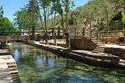
.JPG) Alte river within the village of Alte | |
| Country | Portugal |
|---|---|
| Region | Algarve |
| District | Faro |
| Municipality | Loulé |
| Source | |
| - location | Alte, Algarve |
| - coordinates | PT 37°14′17.7″N 8°09′57.6″W / 37.238250°N 8.166000°W |
| Source confluence | |
| - location | Quarteira River |
| - elevation | 50 m (164 ft) |
| - coordinates | PT 37°10′51.5″N 8°12′28.1″W / 37.180972°N 8.207806°W |
| Mouth | Into the Atlantic at Quarteira |
| Length | 7.2 mi (12 km), North East to South West |
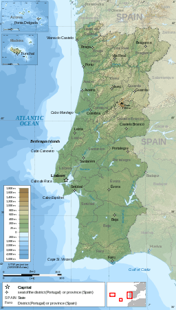 Red Dot = Valley of Alte River
| |
Alte River is a small river in the Portuguese region of the Algarve.[1] The river along with the Algibre River, another tributary, becomes the River Quarteira after the two rivers conflux. The source[2] of the river is a short distance east of the village of Alte and it runs for a distance of 11.6 kilometres (7.2 mi) to its confluence with the River Algibre near the village of Paderne.
Description
The Algibre is one of a number of small rivers in the central Algarve which make up the water ecosystem known as the Querença – Silves Aquifer System.[3]
Gallery
|
.JPG)


.JPG)
.JPG)
References
- ↑ The Algarve. Sheet Map showing the course of the River Alte and its Confluences. Rough guides – Penguin Group. 2010. ISBN 9781848364981.
- ↑ Tours around the Algarve. Reference to Alte and the valley of the Ribeira de Alte and its spring at Fonte Grande. Algarve Tourism Board/ Rotas © Região de Turismo do Algarve. 2008. p. 50.
- ↑ "Quantifying and modelling the contribution of streams that recharge the Querença – Silves Aquifer in south Portugal" (PDF). Information about the Aquifer System. Natural Hazards and Earth System Sciences.
Rivers and Streams of the Algarve | ||
|---|---|---|
 | ||
This article is issued from Wikipedia - version of the 2/28/2016. The text is available under the Creative Commons Attribution/Share Alike but additional terms may apply for the media files.