Ala-Archa River
| Ala-Archa River (Ала-Арча дарыясы) | |
 Ala-Archa River | |
| Country | Kyrgyzstan |
|---|---|
| Region | Chuy Province |
| District | Alamudun District |
| Tributaries | |
| - right | Kashka-Suu River |
| City | Bishkek |
| Mouth | Chu River |
| - coordinates | KG 43°03′44″N 74°38′18″E / 43.0623°N 74.6382°ECoordinates: KG 43°03′44″N 74°38′18″E / 43.0623°N 74.6382°E |
| Length | 78 km (48 mi) |
| Basin | 233 km2 (90 sq mi) |
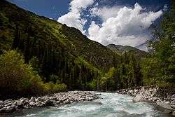
The Ala-Archa River (Kyrgyz: Ала-Арча ) is a river flowing through Alamudun District of Chuy Province of Kyrgyzstan. It rises on the northern slopes of Kyrgyz Ala-Too and flows north to enter the Chu River in Chuy Valley. The Ala-Archa River is 78 kilometres (48 mi) long and has a basin area of 233 square kilometres (90 sq mi).[1] Its water comes mostly from glaciers and snow.[2]
Course
The river runs through Ala Archa National Park and through Bishkek. Other settlements in the river basin are Kashka-Suu, Baitik, Orto Say, Tash-Debe and Mayevka.
References
- ↑ Basic hydrological information about rivers of Chu River basin (in Russian)
- ↑ Чүй облусу:Энциклопедия [Encyclopedia of Chuy Oblast] (in Kyrgyz and Russian). Bishkek: Chief Editorial Board of Kyrgyz Encyclopedia. 1994. p. 718. ISBN 5-89750-083-5.
This article is issued from Wikipedia - version of the 2/28/2016. The text is available under the Creative Commons Attribution/Share Alike but additional terms may apply for the media files.