Ala Archa National Park
| Kyrgyz National Park "Ala-Archa" | |
|---|---|
|
IUCN category II (national park) | |
|
Looking up the Ala Archa river valley | |
 | |
| Location | Chuy Province, Kyrgyzstan |
| Nearest city | Bishkek |
| Coordinates | 42°38′42″N 74°28′48″E / 42.645°N 74.480°ECoordinates: 42°38′42″N 74°28′48″E / 42.645°N 74.480°E |
| Area | 194 square kilometres (75 sq mi) |
| Established | 1976 |

The Ala Archa National Park is an alpine national park in the Tian Shan mountains of Kyrgyzstan, established in 1976[1] and located approximately 40 km south of the capital city of Bishkek. The park, which includes the gorge of the Ala-Archa River and the mountains surrounding it, is a popular destination point for weekend picnickers, hikers, horse trekkers, skiers as well as mountain climbers looking for challenging ice, rock and mixed routes. The park is open year round, although the most popular season is late summer and early fall. Every May 1, the Alpinada festival sees hundreds of people camp out in the valley and climb Mount Komsomolets.
In Kyrgyz, the archa, which gives the park its name, is a bright or many-colored juniper which the Kyrgyz people have traditionally held in special esteem, using smoke from its burning wood to chase away evil spirits. However, the archa is not supposed to be planted near the home, because it is believed gradually to sap the energy from human beings living close-by.
The park covers about 200 square kilometers, and its altitude ranges from about 1,500 meters at the entrance to a maximum of 4,895 meters at Peak Semenova Tian-Shanski, the highest peak in the Kyrgyz Ala-tau range of the Tian Shan. There are more than 20 small and large glaciers and some 50 mountain peaks within the park. Two smaller rivers, the Adygene and the Ak-Sai, originate from these glaciers' melting waters. The Adygene gorge is a beautifully wooded valley, with waterfalls, springs and abundant trout. A small reservoir on the Kargay-Bulak river was built to study the Amu Darya trout. Other wildlife includes the very rare snow leopard (in Kyrgyz: "ilbirs") on the alpine meadows and snowfields above 2,500 m elevation, wild goats, roe deer and marmots. Many plants can be found in the park including;Crocus alatavicus.[2]
There is a nominal fee for entering the park. Past the gate the road continues 12 km to a small collection of buildings, including one newly renovated lodge. At the end of the road, up a trail to the left (East), lies the Ak-Sai Glacier, where remains of a Soviet climbing base indicate the high quality mountaineering within the park. The region's most famous peaks rise from the Ak-Sai glacier, including Korona (4860m) and Free Korea (4740m). To the west of Ala Archa Valley is a trail to the Adygene valley where a climbers' cemetery is located. A third main trail continues down the center of the Ala-Archa valley for 10 km to an old, now abandoned, ski area and numerous other 4000m peaks.
References
"Ala-Archa National Park marks 30th anniversary," in The Times of Central Asia, 16 Nov. 2006 (www.times.ca.com)
- ↑ Особо охраняемые природные территории Кыргызской Республики (по состоянию на конец 2004 года) (Protected areas of the Kyrgyz Republic (as of the end of 2004)) (Russian)
- ↑ Hayes, Patrick. "KYRGYZSTAN" (pdf). kewguild.org.uk. Retrieved 11 October 2014.
External list
Gallery
-
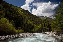
Ala Archa River
-

Ala Archa National Park
-

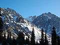
A boulder field at Ala Archa National Park
-
At Ala Archa National Park
-

At Ala Archa National Park
-

At Ala Archa National Park
-
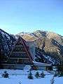
At Ala Archa National Park
External links
| Wikimedia Commons has media related to Ala Archa National Park, Kyrgyz. |
- Ala-Archa National Park in World Database on Protected Areas
- "Ala-Archa National Park - Kyrgyzstan" Waymark
- Ala Archa Climbing information
- Climbing route maps
- Kyrgyz flora and parks