Naryn River
| Naryn River (Нарын дарыясы) | |
| River | |
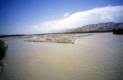 The Naryn River near the town of Naryn | |
| Countries | Kyrgyzstan, Uzbekistan |
|---|---|
| Regions | Naryn Region, Jalal-Abad Region |
| Tributaries | |
| - left | At-Bashi River, Alabuga River |
| - right | On Archa River, Kara-Suu River, Jumgal River, Kökömeren River |
| Cities | Naryn, Naryn Region, Karaköl, Jalal-Abad Region, Tashkömür, Jalal-Abad Region |
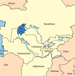
| Mouth | Syr Darya |
| - location | near Namangan, Uzbekistan |
| - elevation | 410 m (1,345 ft) |
| - coordinates | KG 40°54′3″N 71°45′27″E / 40.90083°N 71.75750°ECoordinates: KG 40°54′3″N 71°45′27″E / 40.90083°N 71.75750°E |
| Length | 807 km (501 mi) |
| Basin | 59,100 km2 (22,819 sq mi) |
| Discharge | for near mouth |
| - average | 429 m3/s (15,150 cu ft/s) |
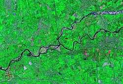
The Naryn River (Kyrgyz: Нарын, Russian: Нарын, Uzbek: Norin) rises in the Tian Shan mountains in Kyrgyzstan, Central Asia, flowing west through the Fergana Valley into Uzbekistan. Here it merges with the Kara Darya River (near Namangan) to form the Syr Darya. It is 807 kilometres (501 mi) long (together with Chong-Naryn River) and has an annual flow of 13.7 cubic kilometres (11,100,000 acre·ft).
The largest tributaries of the Naryn River are: Kichi-Naryn River, At-Bashi River, On Archa River, Kadjyrty River, Chychkan River, Alabuga River, Kökömeren River etc.[1]
The river contains many reservoirs which are important in the generation of hydroelectricity. The largest of these is the Toktogul Reservoir in Kyrgyzstan containing 19.9 cubic kilometres (16,100,000 acre·ft) of water. Dams downstream of the Toktogul in Kyrgyzstan include: Kurpsai, Tash-Kumyr, Shamaldysai and Uch-Kurgansk. Upstream of Toktogul in Kyrgyzstan is the Kambarata-2 and At-Bashi Dams while the Kambarata-1 and Kambarata-3 are in planning stages.[2]
Some places along the river: Kyrgyzstan: Kara-Say (see Barskoon), Naryn Region, Naryn, Dostuk, Jalal-Abad Region, Kazarman, Toktogul Reservoir, Kara-Köl, Tash-Kumyr.
Notes
- ↑ Characteristics of the Rivers of Naryn River Basin (in Russian)
- ↑ "List of major hydroelectric facilities Kyrgyzskoy Republic" (PDF) (in Russian). CA Water. Retrieved 24 February 2012.
External links