1993 Pacific hurricane season
| |
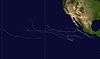
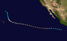
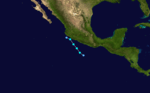
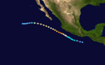
| Season summary map |
| First system formed |
June 11, 1993 |
| Last system dissipated |
October 14, 1993 |
| Strongest storm1 |
Lidia – 930 mbar (hPa) (27.46 inHg), 150 mph (240 km/h) |
| Total depressions |
18 |
| Total storms |
15 |
| Hurricanes |
11 |
| Major hurricanes (Cat. 3+) |
9 |
| Total fatalities |
42 |
| Total damage |
~ $1.7 billion (1993 USD) |
| 1Strongest storm is determined by lowest pressure |
Pacific hurricane seasons
1991, 1992, 1993, 1994, 1995 |
The 1993 Pacific hurricane season was a slightly active Pacific hurricane season with seven named storms directly impacting land. The season officially started on May 15 in the eastern Pacific, and on June 1 in the central Pacific, and ended on November 30; these dates conventionally delimit the period during which most tropical cyclones form in the northeastern Pacific Ocean. The first tropical cyclone developed on June 11, over a month after the traditional start of the season. The final named storm of the season, Tropical Storm Norma, dissipated on October 14. The Central Pacific Ocean saw very little tropical activity, with only one cyclone, Hurricane Keoni, developing in that particular region. However, many storms out of the season crossed the threshold into the Central Pacific, many as hurricanes, and even major hurricanes.
The season produced fifteen named storms, which was slightly below the average of sixteen named storms per season. However, the total of eight hurricanes during the season was slightly above average, and the total of nine major hurricanes was significantly higher than the average of three.[1]
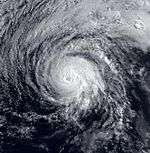
The most intense cyclone of the season was Hurricane Lidia, a powerful Category 4 hurricane that made landfall in Sinaloa as a Category 2. Killing seven people, Lidia also caused extensive property damage in Mexico and the United States, as the remnants of the system combined with a cold front to produce Severe weather in Texas. However, the most notable storm of the season, in terms of fatalities, was Hurricane Calvin. Originating from an area of disturbed weather on July 4, it reached a peak intensity of 110 mph (180 km/h) before making an initial landfall near Manzanillo, Colima, Mexico. Rapidly weakening due to land interaction with the Mexican coastline, the hurricane re-emerged into Pacific waters, though the storm did not strengthen, and continued to weaken as it moved northwestward. On July 8, Calvin made a second, and final, landfall on the southern tip of Baja California Peninsula before weakening to a tropical depression and dissipating on July 9. At least 34 deaths can be attributed to the system, as well as $32 million (1993 USD) or more in damage.
Timeline
Storms
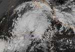
Hurricane Adrian
| Category 1 hurricane (SSHWS) |
|
|
| Duration |
June 11 – June 19 |
| Peak intensity |
85 mph (140 km/h) (1-min) 979 mbar (hPa) |
On June 11, an area of shower and thunderstorm activity situated approximately 835 mi (1,344 km) intensified into a tropical depression. Embedded within a weak steering flow, the depression initially drifted towards the west, and began to organize above high Sea surface temperatures and low wind shear. Eighteen hours after formation, the depression strengthened into a tropical storm, earning the name Adrian, and becoming the first tropical storm of the season. Turning towards the northwest, Adrian gradually strengthened to attain hurricane status by 1200 UTC on June 15, and the storm reached a peak intensity of 85 mph (140 km/h) and a minimum barometric pressure of 979 mbar (28.9 inHg) early the next day. However, the system turned clockwise towards the southeast, wind shear began to take toll on the cyclone, and Adrian weakened to a tropical storm early on June 17. Becoming nearly stationary, Adrian further weakened to a tropical depression late the same day, and dissipated at 1800 UTC on June 19, without any effects to land.[2]
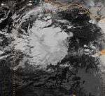
Tropical Storm Beatriz
| Tropical storm (SSHWS) |
|
|
| Duration |
June 18 – June 20 |
| Peak intensity |
65 mph (100 km/h) (1-min) 995 mbar (hPa) |
On June 14, satellite imagery revealed an increase in thunderstorm activity to the south of the Gulf of Tehuanpec. Moving little, a broad surface low developed with the cloud mass, and a tropical wave moved through the area. Although the disturbance remained disorganized, a second tropical wave moved into the region on June 18, when the cloudiness there became better concentrated. According to a post-storm analysis of satellite data and synoptic reports, it is noted that a tropical depression formed at 0600 UTC on June 18, while located approximately 150 mi (240 km) south-southeast of Huatulco, Mexico. Quickly strengthening, the depression intensified a tropical storm six hours later based on a ship report, earning the name Beatriz. Moving generally towards the northwest, partially due to Tropical Storm Arlene's large circulation in the Gulf of Mexico, Beatriz reached a peak intensity of 65 mph (105 km/h) by 1800 UTC on June 19. Shortly thereafter, the system made landfall near Puerto Escondido, Oaxaca and rapidly weakened to a tropical depression over the mountainous terrain of Mexico. Beatriz dissipated at 0600 UTC on June 20, although the remnant cloudiness and associated convection from the storm spread across portions of the western Gulf of Mexico that same day. Beatriz caused extensive damage in southwest Mexico, especially from heavy rains and flooding, with highest rainfall totals of between five and ten inches occurring in Oaxaca, with even higher totals of 11.97 in (304 mm) and 15.46 in (393 mm) from Las Pilas and Salina Cruz. Six deaths were reported in the Mexican states of Morelos and Veracruz from flooding and downed trees attributed to Beatriz.[3] Total losses from the storm amounted to $1.7 billion (1993 USD; $2.79 billion 2016 USD).[4]
Tropical Depression Three-E
| Tropical depression (SSHWS) |
|
|
| Duration |
June 27 – July 2 |
| Peak intensity |
35 mph (55 km/h) (1-min) 1006 mbar (hPa) |
On June 12, a tropical wave moved off the western coast of Africa, and crossed the Atlantic Ocean with little to any development. Moving into the Pacific Ocean, it is estimated that a tropical depression formed at 00 UTC on June 27. Initially moving towards the northwest, the depression, referred to as Three-E, became slightly better organized as it neared the Mexican coastline. Twenty-four hours later, the depression was approximately 50 mi (80 km) off the coast of Mexico, near Puerto Escondidio. Shortly thereafter, the depression began to weaken, likely due to land interaction. Turning towards the west-northwest, the depression accelerated in its forward motion, while remaining in a disorganized state. Shortly thereafter, the Three-E turned back towards the northwest, and began to organize once again. Satellite imagery on June 30 revealed that the depression was close to tropical storm strength, although the system still lacked the organized to be declared as such. For the next several days, Three-E transitioned in movement between north and northwest, and by July 1, the depression approached Baja California. However, likely due to cooler sea surface temperatures and higher wind shear, most of the convection associated with the system had dissipated before it reached the southern portion of Baja California. At 00 UTC July 2, the depression dissipated a short distance north of La Paz.
Shortly before the formation of Tropical Depression Three-E, it is reported that locally heavy rains fell over portions of the states of Chiapas, Oaxaca, and Tabasco, where 24-hour rainfall totals of 8.80 in (224 mm),8.69 in (221 mm), and 8.39 in (213 mm) were reported, respectively. In Atoyac and Acapulco, 24-hour rainfall totals of 7.26 in (184 mm) and 6 in (150 mm) were reported. Additionally, between June 26 and June 29, Acapulco reported a 4-day rainfall total of 11.89 in (302 mm). Lastly, according to an Associated Press wire story, 300 families were evacuated in Mexico, although a specific location is unknown. No deaths or damage was reported in association with the tropical depression.
Hurricane Calvin
| Category 2 hurricane (SSHWS) |
|
|
| Duration |
July 4 – July 9 |
| Peak intensity |
110 mph (175 km/h) (1-min) 966 mbar (hPa) |
The deadliest storm of the season, Hurricane Calvin, was first identified as an area of disturbed weather near the Gulf of Tehuantepec on July 2. Following the development of banding features, the disturbance organized into a tropical depression two days later, while situated 315 mi (507 km) southeast of Acapulco, Mexico. Quickly intensifying, the depression was soon named Calvin as it attained gale-force winds. After initially tracking westward, Calvin turned north and attained hurricane status before reinstating a westward component.[5] Situated just off the coast of Mexico, Calvin attained its peak intensity with winds of 110 mph (175 km/h) on July 7 before moving ashore. Substantially disrupted by the interaction with land, the hurricane rapidly weakened before emerging back over water as a minimal system. Now a tropical depression, Calvin made its final landfall in Baja California Sur before dissipating over cold waters in the region.[6]
Following Calvin's closest approach, the Mexican Weather Service station in Manzanillo recorded a minimum barometric pressure of986.5 mbar (29.13 inHg), as well as 84 mph (135 km/h) surface winds as the center of Calvin passed a little to the west. The Instituto Oceanografico del Pacifico in Manzanillo reported a minimum central pressure of 994 mbar (29.4 inHg). Only two other reports of tropical storm force winds were reported on the Mexican mainland, besides Manzanillo, were reported in associated with Calvin. In Calimo, sustained winds of 60 mph (97 km/h) were observed at 1300 UTC. Shortly thereafter, near 1545 UTC, sustained winds of 35 mph (56 km/h) with gusts up to 45 mph (72 km/h) were reported in the same location. Several ships reported rough weather during Calvin's existence, with the Pacific Sandpiper reporting a maximum wave height of 44 ft (13 m). In Acapulco, it is reported that waves in excess of 15 ft (4.6 m) moved through the city. In several states, heavy rainfall between 5 in (130 mm) to 10 in (250 mm) inches was recorded. However, in Las Pilas, the highest rainfall total was observed, at 16.34 in (415 mm). According to The Miami Herald and the West Hawaii Today, Calvin is blamed for the death of 34 deaths, which includes both direct and indirect. Most of the fatalities came from heavy rainfall associated with the system. A state of emergency was declared in at least ten states in Mexico following Calvin's passage, and the Mexican Defense Department said that 42,063 people were evacuated in eleven states. Additionally, at least 1,600 people were left homeless. Finally, rough seas near Lázaro Cárdenas caused all 4,000 tons of sulfuric acid to leak aboard the previously beached cargo tanker, Betula.[7]
Hurricane Dora
| Category 4 hurricane (SSHWS) |
|
|
| Duration |
July 14 – July 21 |
| Peak intensity |
130 mph (215 km/h) (1-min) 945 mbar (hPa) |
On June 27, a tropical wave emerged off the western coast of Africa and crossed the Atlantic with no further development. On July 9, the wave entered the Eastern Pacific, depicted with little in the way of heavy thunderstorm activity. However, on July 11, deep convection significantly increase in association with the disturbance, and it is estimated that a tropical depression formed three days later, at 1200 UTC. Embedded within an area of low wind shear and warm sea surface temperatures, the depression quickly strengthened into a tropical storm, receiving the name Dora, six hours after formation. Moving towards the west, Dora attained hurricane status at 1800 UTC on July 15, and Category 2 status by early on July 16. Strengthening further, Dora reached major hurricane status early the following morning, and reached its peak intensity of 135 mph (217 km/h) with a minimum barometric pressure of 945 mbar (27.9 inHg) early on July 17. Moving west to west-northwest around the periphery of a subtropical high, the hurricane began to enter cooler sea surface temperatures (SST's) and higher wind shear. Thus, the cyclone weakened to a tropical storm by 1800 UTC on July 18. The following afternoon, Dora weakened to a tropical depression, and dissipated early on July 21. No deaths, damage, or associated impact because of the system was reported to the National Hurricane Center.
Hurricane Eugene
| Category 3 hurricane (SSHWS) |
|
|
| Duration |
July 15 – July 25 |
| Peak intensity |
125 mph (205 km/h) (1-min) 948 mbar (hPa) |
A tropical wave traversed the Atlantic and Caribbean, before reaching the Pacific Ocean in mid-July. Following the development of a low-level circulation about 805 miles (1,296 km) south-southwest of the southern tip of Baja California, the system was classified as Tropical Depression Six-E on July 15. After banding features improved, the depression was upgraded to Tropical Storm Eugene on July 16. The storm continued to strengthen and organize, reaching hurricane status early on July 17. Eugene attained its peak intensity with maximum sustained winds of 125 mph (205 km/h) and a minimum barometric pressure of 948 mbar (28.0 inHg) at 1800 UTC on July 19.[8] After peak intensity, Eugene began to weaken due to increasing wind shear and decreasing SST's,[9] and was downgraded to a tropical storm on July 22.[8]
Eugene crossed 140°W on July 22 and entered the Central Pacific Hurricane Center's area of responsibility. Eugene weakened further and was downgraded to a tropical depression on July 24.[8] At 1200 UTC on July 24, Eugene made landfall near Pahala, Hawaii, with winds of 35 mph (55 km/h).[10] After a buoy near the path of Eugene reported no abnormal weather on July 25, Eugene was declared dissipated at 0600 UTC, while located just southeast of the Hawaiian Islands.[8] Eugene brought much-needed rain to the major Hawaiian Islands. The storm caused no significant damage, only scattered minor blackouts and breaking of tree limbs; roads were also dangerous to drive on. The only fatality in associated with Eugene was the death of a 45-year-old fisherman, who was killed when his boat was destroyed in rough seas.[10]
Hurricane Keoni
| Category 4 hurricane (SSHWS) |
|
|
| Duration |
August 9 – August 19 (left basin) |
| Peak intensity |
130 mph (215 km/h) (1-min) |
An area of disturbed weather developed into Tropical Depression One-C at 0000 UTC on August 9, near 12°N, 144°W. The depression remained disorganized and strengthened slowly over the next three days. Late on August 12, the depression was upgraded to Tropical Storm Keoni. Thereafter, it moved in a move west-northwesterly direction. Keoni intensified into a Category 1 hurricane by late on August 14. Less than 24 hours later, it reached Category 2 intensity. On August 18, Keoni peaked as a 130 mph (215 km/h) Category 4.[10]
The storm passed about 150 miles (240 km) south of Johnston Atoll on August 18. As Keoni approached, about 1000 people evacuated the atoll. It brought rough seas and because the storm was compact, wind gusts reached only 45 mph (72 km/h). By August 17, Keoni began weakened and fell to Category 3 intensity. Six hours later, it weakened to a Category 2 hurricane. Keoni further fell to a Category 1 hurricane on August 18. Late on the following day, Keoni crossed the International Date Line and was re-classified as a typhoon.[10]
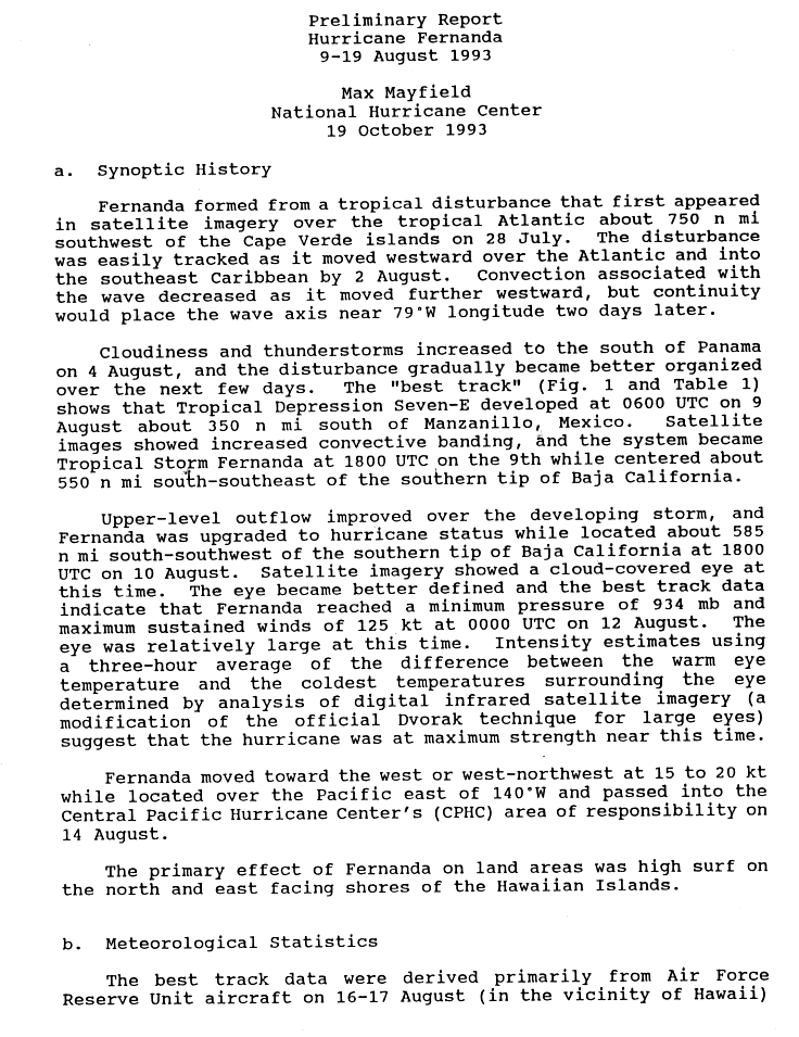
Hurricane Fernanda
| Category 4 hurricane (SSHWS) |
|
|
| Duration |
August 9 – August 19 |
| Peak intensity |
145 mph (230 km/h) (1-min) 934 mbar (hPa) |
Fernanda formed from a tropical wave that moved off the west African coast on July 28 and crossed into the Eastern Pacific Ocean. The developing storm reached tropical storm status on August 9 while 635 mi (1,022 km) south of the southern tip of Baja California, and Fernanda strengthened into a hurricane the next day. Fernanda developed a large and well-defined eye, reaching its peak of 145 mph (235 km/h) on August 12 over the open eastern Pacific. Fernanda eventually crossed into the central Pacific on August 14, and passed as close as 300 mi (483 km) northeast of the Big Island of Hawaii as a Category 2 hurricane on August 16.[11] Fernanda later began to curve slowly to the northwest on August 16 under the influence of an upper-level trough after approaching the Hawaiian Islands, becoming extratropical on August 19 after weakening due to shear and cooler waters, with the remnant circulation merging with the cold upper-level trough.[10]
Although it did not make landfall in the Hawaiian Islands, Fernanda's close approach prompted a hurricane warning for the Big Island and a hurricane watch elsewhere in the islands. Heavy surf and wave action affected the islands, with waves as high as between 15 (5 m) and 20 ft (6 m) reported on Kauai, causing damage to shoreline roads on all of the islands, allowing water intrusion into some homes, and washing one home several feet off its foundation. Many beach parks were also inundated, though evacuations prevented any deaths. In total, Fernanda caused $5 million (1993 USD, $8.2 million 2016 USD) in damage to the Hawaiian Islands, and moisture induced by the interaction of Fernanda and the cold-core trough also affected the islands, producing showers and thunderstorms on all of the islands and localized flooding on Kauai.[10]
Hurricane Greg
| Category 4 hurricane (SSHWS) |
|
|
| Duration |
August 15 – August 28 |
| Peak intensity |
130 mph (215 km/h) (1-min) 948 mbar (hPa) |
On August 10, Tropical Storm Bret made landfall in Nicaragua with maximum sustained winds of 45 mph (72 km/h). Moving quickly inland, Bret weakened to a tropical depression, and dissipated over the mountainous terrain of Central America. Moving off towards west, convection associated with the remnant area of cloudiness developed in intermittent bursts, but by August 14, a more steady trend of development was observed. While centered 290 mi (470 km) south-southeast of Manzanillo, it is estimated that a tropical depression formed around 0000 UTC August 15. According to the National Hurricane Center, satellite imagery on the 15th revealed a much better organized system than twenty-four hours previous, and the depression is estimated to have intensified into a tropical storm at 1200 UTC, receiving the name Greg. Turning towards the west-northwest, the system continued to intensify, attaining hurricane status at 1200 UTC on August 16. At this time, hints of an eye feature was observable on satellite imagery. Rapid intensification then ensued, and Greg became a strong Category 2 hurricane by 1800 UTC, with maximum sustained winds of 105 mph (169 km/h) as a small and fairly well-defined eye became visible. However, shortly thereafter, the eye became obscured from view, an indication that Greg was on a weakening trend. A slowdown in forward motion occurred, and Greg turned towards the west before moving west-southwest, towards the general direction of Socorro Island.
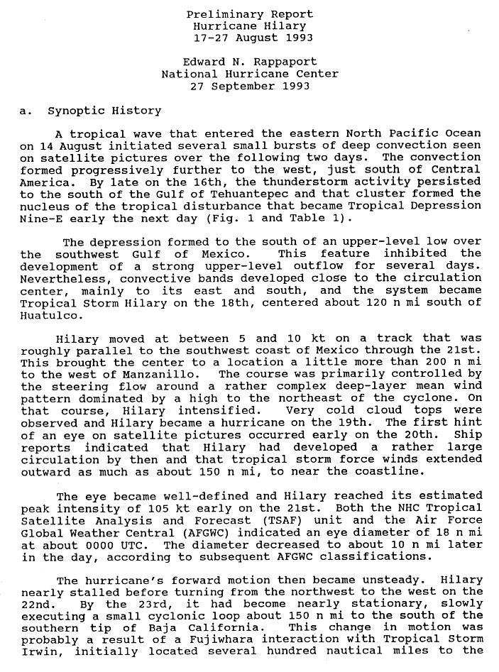
Hurricane Hilary
| Category 3 hurricane (SSHWS) |
|
|
| Duration |
August 17 – August 27 |
| Peak intensity |
120 mph (195 km/h) (1-min) 957 mbar (hPa) |
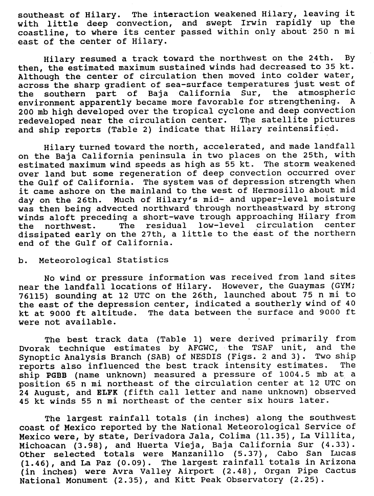
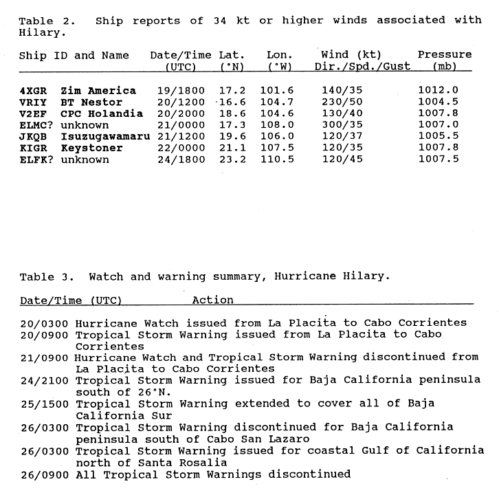
The third in a series of intense August hurricanes, Hilary originated from a tropical wave that crossed Central America on August 14. By August 17, just three days after entering the Eastern Pacific, the wave was sufficiently organized to be declared Tropical Depression Nine-E. Tracking westward, the depression gradually developed, attaining hurricane status two days later. By this time, a ridge situated over the Gulf of Mexico caused Hilary to turn northwestward, parallel to the Mexican coastline. Following the development of an 18 mi (29 km) wide eye on August 21, the storm further intensified into a Category 3 hurricane, attaining peak winds of 120 mph (195 km/h). By August 23, the hurricane nearly stalled as it underwent a Fujiwhara interaction with the newly developed Tropical Storm Irwin. Executing a small counter-clockwise loop, Hilary degraded to tropical storm intensity and took a northerly track for the remainder of its existence.[12] The storm made two landfalls in Mexico, one in Baja California Sur on August 25 and again near Hermosillo, Sonora the following day. The remnants of Hilary were last noted over the northern Gulf of California on August 27.[13]
Due to Hilary's proximity to Mexico on August 20, hurricane watches were issued for much of the southern coastline; however, they were later discontinued. Once the system began its northward track, further advisories were issued for the Baja California Peninsula as well as the Gulf of California coastline.[14] Heavy rains, peaking at 11.35 in (288 mm), accompanied the storm, though no damage or loss of life took place.[13] The outer bands of the storm also brought localized downpours to parts of California, resulting in flash floods.[15]
Tropical Storm Irwin
| Tropical storm (SSHWS) |
|
|
| Duration |
August 21 – August 22 |
| Peak intensity |
70 mph (110 km/h) (1-min) 999 mbar (hPa) |
On August 20, convection increased south of the Gulf of Tehuantepec, when a tropical wave, which is likely responsible for Tropical Storm Cindy's in the Atlantic, moved into the region. Satellite imagery on August 21 revealed an increase in organization associated with the disturbance, and it is estimated that a tropical depression formed at 0600 UTC. Six hours later, the depression was upgraded to a tropical storm after a 59 mph (95 km/h) surface wind was reported by the ship BT Nestor. Receiving the name Irwin, the system moved off towards the northwest, displaying a rather disorganized cloud appearance. Additionally, most satellite wind estimates never topped 45 mph (72 km/h), with the exception being a 50 mph (80 km/h) estimate from the Air Force Global Weather Center at 0427 UTC on August 22. At 2100 UTC on August 21, tropical storm warnings issued from Zihuatanejo to Cabo Corrientes, Mexico in anticipation of the storm's arrival. Despite the system's disorganized cloud appearance, combined observations from nearby ships, as well as a report from Manzanillo, Mexico, reveals Irwin's maximum sustained winds may have been as high as 70 mph (110 km/h) with a minimum barometric pressure of 999 mbar (29.5 inHg), which was set as the storm's peak intensity at 00 UTC on August 22. Paralleling the southern Mexican coastline, Irwin quickly weakened as it began to be absorbed by Hurricane Hilary. By 1800 UTC on August 22, Irwin was fully absorbed by Hurricane Hilary, when the hurricane was situated 250 mi (400 km) west of Irwin. At this time, all tropical storm warnings were discounted for the Mexican coastline.
While located 40 mi (64 km) to the south of Manzanillo, the cyclone generated sustained winds of 66 mph (106 km/h) in the city, as well as a minimum pressure of 1,003.5 mbar (29.63 inHg). At the same time, winds of 100 mph (160 km/h) were reported in the Manzanillo harbor by Peter Maxwell, an owner of the hotel at the time, although, according to the National Hurricane Center, these winds were likely overestimated. In Jala, a maximum rainfall total of 7 in (180 mm) was recorded. No deaths or associated damage was reported with the system.
Hurricane Jova
| Category 4 hurricane (SSHWS) |
|
|
| Duration |
August 29 – September 5 |
| Peak intensity |
130 mph (215 km/h) (1-min) 948 mbar (hPa) |
Light rainfall fell in California.[16]
Hurricane Kenneth
| Category 4 hurricane (SSHWS) |
|
|
| Duration |
September 5 – September 17 |
| Peak intensity |
150 mph (240 km/h) (1-min) 932 mbar (hPa) |
On August 30, a cloud cluster just to the south of Panama was observed by the National Hurricane Center (NHC). Moving towards the west for several days, the disturbance remained relatively disorganized, but was classified as a tropical depression of 1200 UTC on September 5, after Satellite analysts at the NESDIS Synoptic Analysis Branch (SAB) and the NHC Tropical Satellite Analysis and Forecast (TSAF) unit classified the disturbance as a T1.5 by the Dvorak Technique at the time. Additionally, satellite imagery showed a typical banding type pattern, although the associated convection was loosely organized. However, by 0600 UTC September 6, convection had become more intense and better organized. Subsequently, the depression was upgraded to Tropical Storm Kenneth, while situated 625 mi (1,006 km) south of the southern tip of Baja California. At this time, a large circulation associated with Kenneth was evident, with the ship Silvie III reporting40 mph (64 km/h) sustained winds, which was positioned 235 mi (378 km) away from the storm's center. On September 7, deep convection began to markedly increase near the center of circulation, and it estimated that Kenneth attained hurricane status early on September 8. Continuing to strengthen, Kenneth attained Category 2 status at 0600 UTC on September 10, characterized by a distinct eye, and strengthened further to attain major hurricane status six hours later. Moving towards the northwest, Kenneth attained Category 4 status at 1800 UTC, and reached a peak intensity of 150 mph (240 km/h) with a minimum barometric pressure of932 mbar (27.5 inHg) at 0600 UTC on September 11. Shortly thereafter, the storm began to weaken as high wind shear and cooler sea surface temperatures began to impede on the storm. Kenneth weakened to a Category 3 hurricane early on September 12, and a Category 2 hurricane by 1800 UTC. Moving towards the west-northwest, Kenneth became a minimal hurricane late on September 14, and weakened further to tropical storm status at 00 UTC on September 15. The system weakened to a tropical depression on September 16, and finally, after thirteen days as a tropical cyclone, Kenneth dissipated in the open Pacific, without any effects to land.
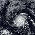
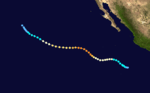
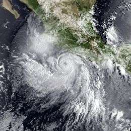
Hurricane Lidia
| Category 4 hurricane (SSHWS) |
|
|
| Duration |
September 8 – September 14 |
| Peak intensity |
150 mph (240 km/h) (1-min) 930 mbar (hPa) |
Forming from a tropical wave on September 8, Lidia steadily organized and became a hurricane on September 10. The hurricane continued to strengthen while developing a well-defined eye, and peaked as a Category 4 hurricane on September 11. However, it weakened considerably before making landfall in Sinaloa as a Category 2 storm. Lidia dissipated near Austin, Texas on September 14 and was later absorbed by a cold front. Across Mexico, the hurricane killed seven people; over 100,000 people were forced to evacuate their homes. A total of 160 homes were destroyed and 10,000 people were left homeless because of the storm. In the United States, five people suffered injuries and storm damage totaled $8 million (1993 USD).
Tropical Depression Fourteen-E (Gert)
| Tropical depression (SSHWS) |
|
|
| Duration |
September 21 – September 26 |
| Peak intensity |
35 mph (55 km/h) (1-min) 1002 mbar (hPa) |
On September 14, a tropical depression formed at 1800 UTC in the southwestern Caribbean, approximately 105 mi (169 km)north of the northern coast of Panama. Moving towards the west-northwest, the depression briefly attained tropical storm status, receiving the name Gert, before moving ashore near Bluefields, Nicaragua on September 15. Shortly thereafter, Gert weakened to a tropical depression, but later attained tropical storm status for a second time in the Gulf of Honduras. Moving shore for a second time in the Yucatán Peninsula, Gert weakened to a tropical depression once again before entering the Bay of Campeche. There, embedded within an environment favorable for strengthened, the system reattained tropical storm status for a final time on September 18. Steadily strengthening, Gert attained hurricane status on September 20, and reached a peak intensity of 100 mph (160 km/h) by 1800 UTC. Three hours later, Gert made a final landfall on the coast of Mexico at peak intensity, just north of Tuxpan, Veracruz.
Moving across the mountainous terrain of mainland Mexico, Gert quickly weakened to a tropical depression upon its emerge into the Pacific, where it was reclassified as Tropical Depression Fourteen-E. Initially moving towards the west, and eventually towards the west-northwest, it is possible that the depression could have been close to tropical storm status before turning towards the southwest, west of the southern tip of Baja California. Deep convection began to decrease on September 24, and two days later, the depression dissipated. There are no reports of deaths or damage associated with Tropical Depression Fourteen-E, although its processor caused many deaths and extensive damage in Mexico.
Tropical Storm Max
| Tropical storm (SSHWS) |
|
|
| Duration |
September 30 – October 4 |
| Peak intensity |
45 mph (75 km/h) (1-min) 1000 mbar (hPa) |
An area of convection, probably associated with a tropical wave from the Atlantic, strengthened a tropical depression at 00 UTC on September 30. Continuing to organize, the depression strengthened into a tropical storm twelve hours later, earning the name Max. However, shortly thereafter, strong wind shear removed convection from atop Max's low-level center, and the system weakened to a tropical depression. As a large upper-level anticyclone began to extend towards the west, the storm wind shear affecting Max resided, and it is estimated that the system reattained tropical storm status late on October 1, as deep convection redeveloped in associated with the cyclone. At 00 on October 2, Max reached its peak intensity of 45 mph (72 km/h) with a minimum barometric pressure of 1,000 mbar (30 inHg). Embedded within a region of weak steering currents, Max meandered for a couple of days while weakening. The system was once again downgraded to a tropical depression during the afternoon hours of October 3, and was later absorbed by a larger Tropical Storm Norma by 00 UTC on October 4. Because the system strayed far from land, no deaths, damage, or effects to land were reported.
Tropical Storm Norma
| Tropical storm (SSHWS) |
|
|
| Duration |
October 2 – October 6 |
| Peak intensity |
50 mph (85 km/h) (1-min) 1000 mbar (hPa) |
On September 29, a large area of disturbed weather was first identified a few hundred miles to the south of Acapulco. Gradually organizing, the disturbance developed a closed, low-level center of circulation on October 2, and subsequently, was upgraded to a tropical depression at 1800 UTC, while centered 600 mi (970 km) south of the southern tip of Baja California. Embedded within a region of low wind shear and warm sea surface temperatures, the depression quickly intensified to attain tropical storm status at 1200 UTC October 3, earning the name Norma. Moving towards the northwest, Norma attained a peak intensity of 50 mph (80 km/h) with a minimum barometric pressure of 1,000 mbar (30 inHg) early on October 4. At this time, the smaller Max was absorbed into Norma's circulation, and the storm moved into an area of southwesterly upper-level flow. Subsequently, Norma began to weaken, and its low-level center became exposed to the southwest of the system's deep convection late on October 4. Weakening to a tropical depression at 00 UTC on October 5, Norma drifted towards the northwest as a swirl of low clouds, and dissipated during the afternoon hours of October 6, without any fatalities, damage, or effects to land.
Tropical Depression Seventeen-E
| Tropical depression (SSHWS) |
|
|
| Duration |
October 11 – October 14 |
| Peak intensity |
35 mph (55 km/h) (1-min) 1009 mbar (hPa) |
On October 11, the last tropical cyclone of the 1993 season developed several hundred miles to the southeast of Baja California. Under seemingly favorable conditions, the depression moved northwest and strengthened slightly to reach a peak intensity of 35 mph (56 km/h) with a minimum barometric pressure of 1,009 mbar (29.8 inHg). Shortly thereafter, the depression began to enter cooler sea surface temperatures and higher wind shear, subsequently dissipating at 00 UTC on October 14, without any effects on land.
Other storms
Tropical Depression Fifteen-W
| Tropical depression (SSHWS) |
|
|
| Duration |
August 11 – August 12 (Exited basin) |
| Peak intensity |
30 mph (45 km/h) (1-min) |
According to the Joint Typhoon Warning Center, on August 11 a tropical depression formed east of the International Dateline, and soon exited CPHC's area of responsibility;[17] however, this storm wasn't included into CPHC database.
Tropical Depression Hattie
| Tropical depression (SSHWS) |
|
|
| Duration |
October 12 – October 15 (Exited basin) |
| Peak intensity |
25 mph (35 km/h) (1-min) |
According to the Joint Typhoon Warning Center, on October 12 a tropical depression formed east of the International Dateline, and 3 days later exited CPHC's area of responsibility;[18] however, this storm wasn't included into CPHC database. As it entered into western Pacific, it strengthened as a tropical storm and received the name Hattie.[18]
Storm names
The following names were used for named storms that formed in the eastern Pacific in 1993. Names that were not assigned are marked in gray. No names were retired, so it was used again in the 1999 season. This is the same list used for the 1987 season with the exception of Kenneth, which replaced Knut and was used to name a storm for the first time in 1993.
|
|
- Irwin
- Jova
- Kenneth
- Lidia
- Max
- Norma
- Otis (unused)
- Pilar (unused)
|
- Ramon (unused)
- Selma (unused)
- Todd (unused)
- Veronica (unused)
- Wiley (unused)
- Xina (unused)
- York (unused)
- Zelda (unused)
|
For storms that form in the Central Pacific Hurricane Center's area of responsibility, encompassing the area between 140 degrees west and the International Date Line, all names are used in a series of four rotating lists. The next four names that were slated for use in 1993 are shown below. However, only one name, Keoni, was used.
See also
References
- ↑ National Hurricane Center (2007). "Tropical Cyclone Climatology". Retrieved 2007-02-25.
- ↑ Lawrence, Miles (July 10, 1993). "Tropical Storm Adrian Preliminary Report Page 1". National Oceanic Atmospheric Administration. National Hurricane Center. Retrieved November 24, 2011.
- ↑ Mayfield, Max (July 31, 1993). "Tropical Storm Beatriz Preliminary Report". National Hurricane Center. Retrieved February 27, 2011.
- ↑ "Hurricanes and Typhoons with Economic Losses of One Billion Dollars or More, 1950-2005" (XLS). Earth Policy. 2008. Retrieved March 6, 2011.
- ↑ Edward N. Rappaport (August 2, 1993). "Hurricane Calvin Preliminary Report". National Hurricane Center. p. 1. Retrieved March 6, 2011.
- ↑ Edward N. Rappaport (August 2, 1993). "Hurricane Calvin Preliminary Report". National Hurricane Center. p. 2. Retrieved March 6, 2011.
- ↑ Edward N. Rappaport (August 2, 1993). "Hurricane Calvin Preliminary Report". National Hurricane Center. p. 2. Retrieved March 6, 2011.
- 1 2 3 4 Lawrence, Miles (October 7, 1993). "Hurricane Eugene Preliminary Report, Page 1". National Hurricane Center. Retrieved February 21, 2011.
- ↑ Rappaport, Edward (July 19, 1993). "Hurricane Eugene Discussion Number Seventeen". National Hurricane Center. Retrieved February 21, 2011.
- 1 2 3 4 5 6 "The 1993 Central Pacific Tropical Cyclone Season". Central Pacific Hurricane Center. Retrieved 2011-02-21.
- ↑ Mayfield, Max (October 19, 1993). "Hurricane Fernanda Preliminary Report, Page 1". National Hurricane Center. Retrieved February 27, 2011.
- ↑ Edward N. Rappaport (September 27, 1993). "Hurricane Hilary Preliminary Report". National Hurricane Center. p. 1. Retrieved March 6, 2011.
- 1 2 Edward N. Rappaport (September 27, 1993). "Hurricane Hilary Preliminary Report". National Hurricane Center. p. 2. Retrieved March 6, 2011.
- ↑ Edward N. Rappaport (September 27, 1993). "Hurricane Hilary Preliminary Report". National Hurricane Center. p. 7. Retrieved March 6, 2011.
- ↑ National Weather Service (February 2010). "A History of Significant Weather Events in Southern California" (PDF). National Oceanic and Atmospheric Administration. Retrieved March 6, 2011.
- ↑ https://news.google.com/newspapers?id=MpMyAAAAIBAJ&sjid=_vADAAAAIBAJ&pg=3970,1110455&dq=tropical+storm+lidia+moisture&hl=en
- ↑ "bwp151993" (TXT). Joint Typhoon Warning Center. 1993. Retrieved November 29, 2015.
- 1 2 "bwp291993" (TXT). Joint Typhoon Warning Center. 1993. Retrieved November 29, 2015.
External links
|
|---|
|
| |
|
-
 Book Book
-
 Category Category
-
 Portal Portal
-
 WikiProject WikiProject
-
 Commons Commons
|


