1943 Atlantic hurricane season
| |
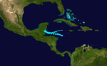
| Season summary map |
| First system formed |
July 25, 1943 |
| Last system dissipated |
October 26, 1943 |
| Strongest storm1 |
Three – 140 mph (220 km/h) (1-minute sustained) |
| Total depressions |
11 |
| Total storms |
10 |
| Hurricanes |
5 |
| Major hurricanes (Cat. 3+) |
2 |
| Total fatalities |
19 |
| Total damage |
$17.2 million (1943 USD) |
| 1Strongest storm is determined by lowest pressure |
Atlantic hurricane seasons
1941, 1942, 1943, 1944, 1945 |
The 1943 Atlantic hurricane season officially began on June 16, 1943, and lasted until October 31, 1943. These dates conventionally delimit the period of each year when most tropical cyclones form in the Atlantic basin.
The 1943 hurricane season was fairly quiet but was significant for one event: the Surprise Hurricane in July was the first tropical cyclone to be investigated by airplane. Two more flights were made during August into a stronger hurricane in the central Atlantic. These early flights paved the way for the Hurricane Hunters forecasters at the National Hurricane Center have come to rely.
Storms
Hurricane One
| Category 2 hurricane (SSHWS) |
|
|
| Duration |
July 25 – July 30 |
| Peak intensity |
105 mph (165 km/h) (1-min) 967 mbar (hPa) |
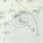
This system developed from an area of disturbed weather over the northeastern Gulf of Mexico on July 25. The storm gradually strengthened while tracking westward and reached hurricane status late on July 26. Thereafter, the hurricane curved slightly west-northwestward and continued intensifying. Early on July 27, it became a Category 2 hurricane and peaked with winds of 105 mph (165 km/h). The system maintained this intensity until landfall on the Bolivar Peninsula in Texas late on July 27. After moving inland, the storm initially weakened rapidly, but remained a tropical cyclone until dissipating over north-central Texas on July 29.
Because the storm occurred during World War II, information and reports were censored by the Government of the United States and news media. Advisories also had to be cleared through the Weather Bureau office in New Orleans, resulting in late releases. This in turn delayed preparations ahead of the storm. In Louisiana, the storm produced gusty winds and heavy rains, though no damage occurred. The storm was considered the worst in Texas since the 1915 Galveston hurricane. Wind gusts up to 132 mph (212 km/h) were reported in the Galveston-Houston area. Numerous buildings and houses were damaged or destroyed. The storm caused 19 fatalities, 14 of which occurred after two separate ships sunk. Overall, damage reached approximately $19 million.
Tropical Storm Two
| Tropical storm (SSHWS) |
|
|
| Duration |
August 13 – August 19 |
| Peak intensity |
60 mph (95 km/h) (1-min) 1005 mbar (hPa) |
This storm formed near the Leeward Islands on August 13 and moved generally northwest for the next four days, shifting slightly more northward late on August 15. Its winds peaked at 60 mph (97 km/h) and the storm recurved to the northeast on August 18 several hundred miles southeast of Cape Fear, dissipating in the north Atlantic a day later.
Hurricane Three
| Category 4 hurricane (SSHWS) |
|
|
| Duration |
August 19 – August 25 |
| Peak intensity |
140 mph (220 km/h) (1-min) |
On August 19, a tropical storm was first observed east of the Lesser Antilles. It headed northwestward, strengthening to a hurricane on August 20 over the open Atlantic. The hurricane peaked at 140 mph (230 km/h) winds, Category 4 on the Saffir-Simpson Hurricane Scale and passed 100 miles (160 km) west of Bermuda on August 25. The storm was very large and despite the distance, Bermuda briefly reported hurricane-force winds, but these winds caused little damage or injury. The hurricane turned northeastward, and became extratropical on August 26 over the North Atlantic.
Hurricane Four
| Category 3 hurricane (SSHWS) |
|
|
| Duration |
September 1 – September 9 |
| Peak intensity |
120 mph (195 km/h) (1-min) |
The fourth storm of the season had an erratic track across the open Atlantic not far east of Bermuda in early September. It formed well southeast of Bermuda and was not discovered until it was almost a hurricane. The hurricane moved north-northwest, steadily strengthening until it was parallel to Bermuda on September 3. By that time, it was a Category 2 hurricane and was getting still stronger. The hurricane came under influence of a strong high pressure system that slowed it to a crawl. It began to slowly curve eastward and then back north and west, making a half circle that it took four days to complete. In that time it reached its peak intensity of 120 mph (190 km/h), a major hurricane on the Saffir-Simpson Hurricane Scale. The hurricane was weakening now, but not much given the latitude. The storm did not drop below Category 2 status until it was almost across 40N. It recurved to the northeast, finally weakening to a tropical storm shortly before clipping Cape Breton Island, Nova Scotia. The storm sped up and ended its days over Newfoundland, having become extratropical.
Tropical Storm Five
| Tropical storm (SSHWS) |
|
|
| Duration |
September 13 – September 15 |
| Peak intensity |
50 mph (85 km/h) (1-min) 1005 mbar (hPa) |
Storm Five, which was possibly a subtropical cyclone, formed northeast of Grand Bahama Island on September 13 and headed due north for the next 24 hours, passing not more than a couple hundred miles off the US east coast, bring gale-force winds to the Outer Banks. No damage from these winds was reported, however. The storm curved northeastward and became extratropical 150 miles (240 km) southeast of Cape Cod.
Hurricane Six
| Category 2 hurricane (SSHWS) |
|
|
| Duration |
September 15 – September 20 |
| Peak intensity |
100 mph (155 km/h) (1-min) |
A tropical storm developed in the western Gulf of Mexico on September 15. It moved to the northwest and became a hurricane early the next day. A ridge of high pressure to the north forced the hurricane southward, where it attained a peak of 100 mph (160 km/h) winds on September 17. It rapidly weakened as it drifted northeastward, completing a tight loop, and hit southern Louisiana on September 20 as a minimal tropical storm. It dissipated shortly thereafter, after causing $195,000 (1943 dollars) in damage, mostly from flooding.
Tropical Storm Seven
| Tropical storm (SSHWS) |
|
|
| Duration |
September 28 – October 2 |
| Peak intensity |
65 mph (100 km/h) (1-min) 997 mbar (hPa) |
A tropical wave formed into a tropical storm on September 28, south-southwest of Bermuda. It headed northwestward, reaching a peak of 60 mph (97 km/h) winds the next day. The storm made landfall near Ocean City, Maryland on October 1, and dissipated later that day. Tropical Storm Seven was responsible for sinking one small boat and causing $20,000 in damage (1943 dollars).
Tropical Storm Eight
| Tropical storm (SSHWS) |
|
|
| Duration |
October 1 – October 3 |
| Peak intensity |
70 mph (110 km/h) (1-min) 999 mbar (hPa) |
This storm was first discovered on October 1 several hundred miles southeast of Bermuda while at its peak intensity of 70 mph (110 km/h), near-hurricane force. The storm moved swiftly, forming a long curve. It passed right by Bermuda shortly before weakening from peak intensity, raking the island with 40 mph (64 km/h) sustained winds. It continued its parabolic recurve to the north and then northeast, picking up speed as it did so. It became extratropical a few hundred miles south-southeast of Cape Breton Island three days after discovery. No damage was reported in Bermuda.
Hurricane Nine
| Category 2 hurricane (SSHWS) |
|
|
| Duration |
October 11 – October 17 |
| Peak intensity |
110 mph (175 km/h) (1-min) |
On October 11, a tropical storm was first detected over the Lesser Antilles. It moved westward, reaching hurricane strength the next day. The hurricane turned due northward and moved through the Mona Passage on October 15. It wouldn't change direction much for the remainder of its lifetime. Early the next day, the hurricane reached a peak of 110 mph (180 km/h) winds, which it maintained before weakening dramatically early on October 17. The hurricane became extratropical later that day, and moved inland near the Maine/New Brunswick border, dissipating over Canada.
Tropical Storm Ten
| Tropical storm (SSHWS) |
|
|
| Duration |
October 20 – October 26 |
| Peak intensity |
45 mph (75 km/h) (1-min) 1004 mbar (hPa) |
The final storm of the season was a weak system that formed in the western Caribbean Sea on October 20 and curved northwest and then west, paralleling the coast of Honduras but remaining well offshore. Winds in this storm never rose above 45 mph (72 km/h). It began to curve back southwest on October 22, clipping the coast of southern Belize and making landfall on the Guatemalan coast six hours later as a weak tropical storm. The storm dissipated over the center of the country.
External links
|
|---|
|
| |
|
-
 Book Book
-
 Category Category
-
 Portal Portal
-
 WikiProject WikiProject
-
 Commons Commons
|