1915 Galveston hurricane
| Category 4 major hurricane (SSHWS/NWS) | |
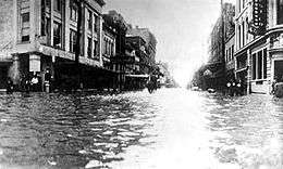 Flooding in Galveston after the hurricane. | |
| Formed | August 5, 1915 |
|---|---|
| Dissipated | August 23, 1915 |
| Highest winds |
1-minute sustained: 145 mph (230 km/h) |
| Lowest pressure | 940 mbar (hPa); 27.76 inHg |
| Fatalities | 400 direct |
| Damage | $50 million (1915 USD) |
| Areas affected | Lesser Antilles, Puerto Rico, Hispaniola, Jamaica, Cuba, Cayman Islands, Yucatán Peninsula, Louisiana, Texas, Oklahoma, Arkansas, Eastern United States, Eastern Canada |
| Part of the 1915 Atlantic hurricane season | |
The 1915 Galveston hurricane was a deadly hurricane that struck Leeward Islands, Hispaniola, Cuba and Texas, in mid August of the 1915 Atlantic hurricane season. Striking Galveston, Texas, 15 years after the 1900 Galveston Hurricane, its 21-ft (6.4-m) waves[1] were slowed by the new Galveston Seawall but changed the beach structure: on August 17, the entire 300-ft (91.5–m) beach was eroded to become an offshore sandbar, later returning partially, but never the same.[1] The 1915 storm caused a great deal of destruction in its path, leaving 275-400 people dead and $50 million (1915 USD, $921 million 2005 USD) in damage.[1]
Meteorological history

A Cape Verde type hurricane, the 1915 Hurricane was detected as a tropical storm moving westward on August 5. Then it was officially observed on August 10 as a Category 1 hurricane. By that time, the storm was centered north of Barbados. On August 11, the eye of the hurricane passed south of the Virgin Islands and Puerto Rico. A weather station in San Juan recorded a 29.60 inch (987 mbar) pressure reading and winds up to 60 mph (110 km/h). The hurricane continued to move westward between 18 and 20 mph (25–30 km/h) where it brushed Haiti and made landfall in Jamaica.[2] A barometric pressure reading of 29.68 inch (983 mbar) was reported in Jamaica. The 1915 hurricane then turned slightly west-northwest, brushing Cuba as it went along. Unfazed by the landfall on Jamaica, the hurricane rapidly intensified and was located near Isle of Pines, Cuba on August 14 with 145 mph (230 km/h) winds. On the 15th, the hurricane was in the central Gulf of Mexico still moving in a northwesterly direction. On August 16, the center of the storm was approaching the east coast of Texas, where the storm weakened slightly but was still a Category 4 storm.[3] On the 17th, the hurricane made landfall southwest of Galveston, Texas. Atmospheric pressure at landfall was at 27.76 inches (940 mbar) and 135 mph (215 km/h) winds. After leaving Galveston, the weakening storm took a turn to the northeast and passed Houston as a Category 1 hurricane before dropping to tropical storm status later that day. On August 20, the dying storm passed over Missouri and the Ohio Valley before finally becoming extratropical on August 23.
Preparations
Forecasters began to issue advisories to weather stations in the United States when the storm was detected on August 5. Forecasters then began to issue warnings to Haiti and Cuba on August 11. Evacuation reports in both Cuba and Haiti, however, are unavailable. After the storm hit Jamaica, forecasters predicted the storm might hit southern and western Cuba. Between August 12 and 13, forecasters began to issue tropical storm warnings to the Florida Keys and Miami, Florida ahead of the storm due to shipping interests.[2] By August 13, the hurricane trekked westward as forecast. At 5 PM (EST), the tropical storm warnings were then changed to hurricane warnings which extended to the Florida Panhandle. On the 14th, however, the hurricane did not recurve north and warnings for Miami and later the Florida Keys were dropped, as the storm instead continued west-northwest. Because the 1915 hurricane was large (exact size unknown), forecasters began to issue tropical storm warnings from coastal Louisiana to the Florida Panhandle. In addition, warnings were issued in Brownsville, Texas. Since it was clear that the hurricane would make landfall in Texas, the warnings were changed for the entire Texas coastline. After the hurricane made landfall, officials continued to issue warnings until the storm dissipated on August 23.[2]
Impact
| Rank | Hurricane | Season | Cost (2015 USD)[6] |
|---|---|---|---|
| 1 | "Miami" | 1926 | $190.3 billion |
| 2 | Katrina | 2005 | $130.9 billion |
| 3 | "Galveston" | 1900 | $120.4 billion |
| 4 | "Galveston" | 1915 | $82.3 billion |
| 5 | Andrew | 1992 | $67.5 billion |
| 6 | "New England" | 1938 | $47.5 billion |
| 7 | "Cuba–Florida" | 1944 | $46.9 billion |
| 8 | "Okeechobee" | 1928 | $40.6 billion |
| 9 | Ike | 2008 | $34.1 billion |
| 10 | Donna | 1960 | $32.4 billion |
| Main article: List of costliest Atlantic hurricanes | |||
The 1915 Hurricane took a path similar to the 1900 Galveston Hurricane, but it affected a large area as it brought strong winds and heavy rains to the Leeward Islands, Puerto Rico, Hispaniola and Cuba. When the hurricane made landfall in Galveston, it brought heavy rains and strong winds, leaving $921 million (2005 USD) in damage. However, unlike the 1900 Galveston Hurricane, only 11 people were killed in the Galveston town area, due to the Galveston Seawall, built after the 1900 storm.
Caribbean Sea
While crossing the Caribbean, the hurricane left moderate damage. In Martinique, the hurricane flooded docks and wrecked small boats, but damage overall was minimal. Damage in the Leeward Islands and Puerto Rico was also limited to small boats and docks. No monetary value is available. In Jamaica and Haiti, there was serious crop damage but according to reports, there were no deaths.[2] In Cuba, however, the damage was severe, as the hurricane devastated the town of Cape San Antonio and destroyed a lighthouse and all of the weather equipment belonging the Weather Bureau. Offshore, the hurricane damaged or sank two schooners, but there was no loss of life. Because of lack of advanced reporting, the death toll in Cuba is unknown.[2]
Yucatán Channel and Gulf of Mexico
Although the hurricane did not make landfall in western Cuba, the Florida Keys or Yucatán Peninsula, the outer rainbands of the storm still produced tropical storm force winds and scattered downpours. In Key West, gale-force winds were reported, but there were no reports of damage. Offshore, numerous ships and boats caught out in the hurricane limped home with moderate damage.[2] In the Yucatán Channel, however, the hurricane sank a U.S. steamer Marowjine, bound from Belize. Despite the fact that the ship was equipped with radios, the ship sank, drowning all 96 passengers and crew. In the northern Gulf of Mexico, a schooner sank several miles south of Mobile, Alabama: there were three fatalities. Several miles east, off the coast of Pensacola, Florida, there were two more fatalities when a fishing boat ran aground. In the central Gulf of Mexico, another schooner was lost, but the crewmen survived.[2] In all, the hurricane left 101 people dead in the Gulf of Mexico and Yucatán Channel.
Louisiana
The outerbands of the 1915 hurricane brought heavy rains and gale-force winds to Louisiana. The damage in Louisiana was <$1 million (1915 USD), and it was limited to agriculture and marshes.[2] There were no reports of fatalities or injuries.
Texas
The 1915 Hurricane made landfall on the Texas coast as a Category 4 hurricane with sustained winds of 135 mph (215 km/h). The areas in Texas hardest hit were Galveston and Houston. In Galveston, the death toll was only eleven due to a recently built seawall. Elsewhere there were 111 fatalities (42 in Galveston Island and 62 offshore), and 102 others were reported missing and assumed dead. Total damage was $56 million (1915 USD).[7]
In Galveston, the hurricane brought 120 mph (200 km/h) winds and tides 9–14 feet above normal and a storm surge of 16.2 feet (4.9 m).[1][8] The storm surge of the hurricane partly damaged the seawall protecting Galveston, which resulted in severe flooding. At 39th street, the 4-masted schooner Crockett was picked up by the storm surge, dragging 2 anchors to snag the seawall, and the schooner was broken into pieces atop the seawall. However the seawall held up, preventing a repeat of the 1900 Galveston Hurricane, but erosion behind damaged the pavement on top from 6th to 18th street.[1] In addition, the hurricane completely washed out 300 ft (91.5 m) of beach up to the seawall,[1] which became an offshore sandbar, but later returned partially, yet never the same.

Elsewhere in the city, many businesses were flooded with 5–6 feet of water. In Fort Crockett, the hurricane destroyed or damaged many of the dune-protected forts and military equipment leaving $1 million (1915 USD) in damage. In all, 250-300 homes outside the seawall were destroyed, and there were only a few deaths due to advanced warnings. In all, there was $6 million (1915 USD) in damage and eleven deaths in the city of Galveston and 42 deaths elsewhere in Galveston Island.[2]
This hurricane damaged Port Bolivar, and its port was mostly not rebuilt.[9]
In Houston, the hurricane brought 80 mph (130 km/h) winds[1] and heavy rainfall that left $1 million (1915 USD) in damage, but there were no reports of fatalities or deaths in the city. The storm significantly damaged much of the cotton, corn, and rice harvests. Rainfall from the storm peaked at 19.83 inches (504 mm) at San Augustine, Texas.[10]
Rest of the United States
The dissipating remnants of the 1915 hurricane dumped heavy rains across the eastern Midwest and Ohio Valley states before fading out for good on August 23. The rains caused extensive flash flooding that left significant damage from Missouri to New York. Exact damage totals and reports of deaths or injuries are unknown.[2]
Aftermath
In Galveston, a series of fires broke out after the storm's passage, and relief aid was slow because the causeway that connected Galveston to mainland Texas was badly damaged. The cost of repairing the bridge was $500,000 dollars (1915 USD). The damage to the bridge and a key water main caused a significant water shortage that lasted until August 16. The damage to post offices and radio stations disrupted mail service and communication.[2]
-

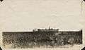
Destroyed causeway from arched bridge to mainland after 1915 Hurricane
-
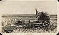
Man with the remains of his home after the 1915 Galveston Hurricane
-
Storm victims graves near Texas City, Texas, following 1915 Galveston Hurricane
-

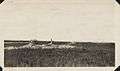
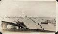
Storm Surge damage from the 1915 Hurricane
-
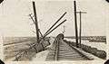
Wreckage of Interurban tracks at Virginia Point after 1915 Galveston Hurricanes
-

Close up of Interurban passenger cars off track after 1915 Galveston Hurricane
-
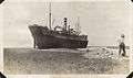
Freight vessel stranded on land after hurricane in Houston
-
Destroyed causeway to Galveston
-
Stranded freight vessels
-

View down Q Street in Galveston, after 1915 Hurricane
-

Wreckage of a bridge and car from causeway collapse after 1915 Galveston Hurricane
See also
| Wikimedia Commons has media related to Galveston hurricane of 1915. |
References
- 1 2 3 4 5 6 7 NWS Houston/Galveston (2007-01-30). "Upper Texas Coast Tropical Cyclones in the 1910s - 1915". NOAA. Archived from the original on 28 September 2008. Retrieved 2008-09-19.
- 1 2 3 4 5 6 7 8 9 10 11 1915 Monthly Weather Review
- ↑ Hurricane Research Division. "HURDAT Meta-Data". NOAA. Archived from the original on 16 March 2008. Retrieved 2008-02-15.
- ↑ Pielke, Roger A., Jr.; Gratz, Joel; Landsea, Christopher W.; Collins, Douglas; Saunders, Mark A.; Musulin, Rade (2008). "Normalized Hurricane Damage in the United States: 1900–2005" (PDF). Natural Hazards Review. 9 (1): 29–42. doi:10.1061/(ASCE)1527-6988(2008)9:1(29). Archived from the original (PDF) on June 17, 2013. Retrieved May 7, 2009.
- ↑ Blake, Eric S.; Landsea, Christopher W.; Gibney, Ethan J. (2011). "The Deadliest, Costliest, and the most intense United States Tropical Cyclones from 1851 to 2010 (and other frequently requested hurricane facts)" (PDF). NOAA Technical Memorandum NWS NHC-6.
- ↑ United States nominal Gross Domestic Product per capita figures follow the Measuring Worth series supplied in Johnston, Louis; Williamson, Samuel H. (2016). "What Was the U.S. GDP Then?". MeasuringWorth. Retrieved April 10, 2016. These figures follow the figures as of 2015.
- ↑ STP.UN.edu
- ↑ Tamu.edu
- ↑ "Port Bolivar". Galveston County Historical Museum. Archived from the original on 2013-06-18. Retrieved 2013-06-11.
- ↑ United States Corp of Engineers (1945). Storm Total Rainfall In The United States. War Department. p. LMV 1–10.
External links
- University of Houston Digital Library, view more pictures of the 1915 Galveston Hurricane