List of neighborhoods in Edison, New Jersey
Edison, New Jersey is a township in Middlesex County, New Jersey in central New Jersey. The township was originally founded as the settlement of Piscatawaytown, a small neighborhood that still exists within it,[1][2][3] and incorporated as Raritan Township on March 17, 1870.[4]
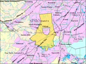
As of the 2010 United States Census, Edison had a total population of 99,967, making it the fifth-most populous municipality in New Jersey.[5][6] Edison's population reached 100,000 in 2010 and had increased to a Census-estimated 100,693 by 2018. The township had a total area of 30.638 square miles (79.351 km2).[7]
Edison is crisscrossed by several major roads, including Interstate 287, the New Jersey Turnpike, U.S. Route 1, Route 27, and Route 440, with various sections and neighborhoods interspersed between them.[2] Large acreages of the closed Raritan Arsensal, Camp Kilmer and the Edison Assembly have given way to mixed-use projects.
Some historical communities date to the 17th century; until the 20th century the township was a collection of "crossroad" communities.[8] The sprawling township does not have an actual "downtown".[9][10][11] A section of Raritan Township was taken to form Metuchen on March 20, 1900. While it is a separate municipality, it remains fully enclaved by and is the geographic center of Edison,[10] a so-called 'doughnut' town.[12][13][14][15]
List of sections and neighborhoods
| Name | Image | Coordinate | Notes | References |
|---|---|---|---|---|
| Bonhamtown | _at_Morris_Avenue_in_Edison_Township%252C_Middlesex_County%252C_New_Jersey.jpg.webp) |
40°31′24″N 74°21′28″W | The neighborhood began as colonial village that was part of Woodbridge Township.[16][17] It is named after Nicholas Bonham, a freeholder from the 17th century. Along with New Dover, New Durham, and Stelton it is one of the older historical communities established in the colonial era. | [18][19][8][20][2][21][22][1] |
| Camp Kilmer site | 40°31′15″N 74°24′47″W | Abutting the Livingston Campus (Rutgers University) in Piscataway, the Edison portion of the former military base has been redeveloped, partially as housing. | [23][24][25] | |
| Clara Barton | 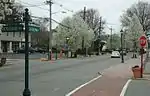 |
40°32′03″N 74°20′22″W | Named for Clara Barton. Located in the eastern part of the sprawling township, Clara Barton is more urban in its density and has a small central business district on Amboy Avenue.[26] The "village-like" section of is separated from the township's bustling highways and stretches of retail and is home to one of the township's three public libraries.[27] The Middlesex Greenway runs through the neighborhood. | [28][19][2] |
| Greensand |  |
40°29′30″N 74°23′14″W | Site of the Kin-Buc Landfill, where Edmonds Creek mouths at the Raritan River. Heller Industrial Park is a built on a former sand mine.[29] | [30][31][2][32] |
| Haven Homes | 40°30′34″N 74°24′23″W | [33][34][2] | ||
| Lahiere | 40°31′08″N 74°24′09″W | Lahiere is a neighbohood in the Stelton section near Edison station. | [35][36][2] | |
| Lincoln Park | 40°31′08″N 74°24′09″W | [35][36][2] | ||
| Lindenau | 40°30′54″N 74°24′40″W | Lindenauis a neighborhood of the Stelton section near Edison station. | [37][38][2] | |
| Martins Landing | 40°29′35″N 74°23′59″W | Located on the northern banks of the Raritan River at the mouth Martins Creek between the Basilone and Goodkind bridges. | [39][40][2] | |
| Menlo Park | 40°33′54″N 74°20′15″W | Menlo Park is where, in 1876, Thomas Edison set up his home and research laboratory. | [41] | |
| Menlo Park Mall | 40.53833°N 74.37861°W | Super regional shopping mall on U.S. Route 1 at Parsonage Road, proposed in 1953,[42] opened in 1959. | ||
| Metropark | 40.56808°N 74.329795°W | Largely located in neighboring Iselin, the office park built around Metropark station on New Jersey Route 27 | ||
| Middlesex County College |  |
40°30′21″N 74°21′58″W | Sited 159 acres (64 ha) of the former Raritan Arsenal.[43] | |
| New Dover | 40°35′06″N 74°20′36″W | The neighborhood began as colonial village that was part of adjacent Woodbridge Township.[16][17] | [44][45][2] | |
| New Durham | _at_Talmadge_Road_in_Edison_Township%252C_Middlesex_County%252C_New_Jersey.jpg.webp) |
40°32′37″N 74°24′22″W | [46][47][2][8] | |
| Nixon | 40°30′51″N 74°22′03″W | [48][45][8] | ||
| North Edison | 40°36′00″N 74°22′39″W | [49][50][2] | ||
| Oak Tree |  |
40°34′40″N 74°22′36″W | An area of the battlefield of the Oak Tree Engagement, part of the Battle of Short Hills, encompassing about 300 acres (120 ha) was listed on the National Register of Historic Places in 2014 as the Short Hills Battlefield Historic District.[51] Oak Tree Pond Park is used as a reenactment site.[52][53] | [54][45][2] |
| Oak Tree Road |  |
Shopping strip runs through Edison and neighboring Iselin[55][56][57] and is considered the largest and most diverse South Asian cultural hub in the United States.[58][59] | ||
| Phoenix | 40°31′47″N 74°20′28″W | Located in the eastern part of the township, Phoenix is a just adjacent to Clara Barton south of the Middlesex Greenway and north of Interstate 287. | [60][61][2] | |
| Piscataway | _just_north_of_Middlesex_County_Route_514_(Woodbridge_Avenue)_in_Edison_Township%252C_Middlesex_County%252C_New_Jersey.jpg.webp) |
40°30′06″N 74°23′45″W | This is the oldest neighborhood in Edison. Along with Quibbletown and Raritan Landing Piscataway town was an early village in Piscataway. Comprising former sections of Piscataway and Woodbridge townships, Edison was settled (by Europeans) in the 17th century. Piscataway is centered around St. James Church and the Piscatawaytown Common, near the intersection of Plainfield and Woodbridge Avenues. | [2][62][52][63][1] |
| Potters | 40°35′37″N 74°21′41″W | In the northern part of the township Potters was once known as Potters Crossing, and may been an African-American community as early as the 1800s.[64] Centered around Iman Avenue and Grove Street[65] it is believed seven upper-middle-class families moved to the village from Harlem in 1917. The community grew in the 1920s, with families from the South. By the 1940s, it had more than 1,500 residents and included three churches and a volunteer fire department.[66][67] The neighborhood was dispersed during an urban renewal project in the 1960s.[64] | [68][61][2] | |
| Pumptown | _at_Plainfield_Road_(Middlesex_County_Route_661)_in_Edison_Township%252C_Middlesex_County%252C_New_Jersey.jpg.webp) |
40°33′47″N 74°22′24″W | Pumptown is a residential neighborhood with a suburban population density. Housing is primarily made up of medium-sized to large occupied single-family homes and townhomes. Many of the residences in the Pumptown neighborhood are older and well-established, built between 1940 and 1969. A number of residences were also built between 1970 and 1999.[69] | [70][61][2] |
| Raritan Center |  |
40°31′21″N 74°20′16″W | Sited on part if the former Raritan Arsenal,[43] the Raritan Center Business Park is a 2,300-acre logistics center with office buildings and millions of square feet of light manufacturing or distribution. It provides services fo transload, cross-dock, warehousing and “3PL” service providers operations. It is home to regional distribution facilities for world class organizations including FedEx, The Home Depot, Certainteed, Arizona Beverages, among others.[71] | |
| Raritan Manor | 40°32′11″N 74°20′12″W | [72][73][2] | ||
| Sand Hills | 40°31′30″N 74°19′10″W | Sand Hills is a neighborhood straddling Edison and adjacent Woodbridge. | [74][75][2][76] | |
| Silver Lake | 40°29′46″N 74°24′10″W | A small lake of same name borders the neighborhood. | [77] | |
| Stelton | 40°30′51″N 74°24′13″W | One the oldest parts of Edison. | [78][79][80] | |
| Valentine | _at_Walsh_Avenue_in_Edison_Township%252C_Middlesex_County%252C_New_Jersey.jpg.webp) |
40°31′51″N 74°19′32″W | Valentine is adjacent to the Fords section of Woodbridge. | [81][79][2] |
| Vineyard Village | 40°31′29″N 74°22′32″W | Adjacent to former Edison Assembly. Edward Antill, a colonial politician, owned large tracts of land (800 acres) in what was then Piscataway, including vineyards. | [8][82] | |
| Washington Park | 40°30′50″N 74°23′54″W | Washington Park is to the east of Stelton. | [83][84][2] |
See also
References
- Gordon, Thomas Francis (1834). "A Gazetteer of the State of New Jersey: Comprehending a General View of Its Physical and Moral Condition, Together with a Topographical and Statistical Account of Its Counties, Towns, Villages, Canals, Rail Roads, &c., Accompanied by a Map".
- "NJDOT Graphic Information System Maps Middlesex" (PDF). New Jersey Department of Transportation. Retrieved March 2, 2020.
- Middlesex COunty Office of Culture and Heritage. "History Revealed In Piscatawaytown and Edison", TAP into Piscataway, September 9, 2015. Accessed December 22, 2019. "The remnants of the Piscataway village and town commons can still be seen in modern Edison Township. Settled in the late 1600s by New Englanders, this historic site once consisted of a town hall, militia training ground, stockade, jail, church, burial ground and houses."
- Snyder, John P. The Story of New Jersey's Civil Boundaries: 1606–1968, Bureau of Geology and Topography, Trenton, New Jersey, 1969. p. 170 re Edison Township, p. 173 re Raritan Township.
- The Counties and Most Populous Cities and Townships in 2010 in New Jersey: 2000 and 2010 Archived 2016-01-13 at the Wayback Machine, New Jersey Department of Labor and Workforce Development. Accessed December 21, 2016.
- Table 7. Population for the Counties and Municipalities in New Jersey: 1990, 2000 and 2010 Archived 2017-08-07 at the Wayback Machine, New Jersey Department of Labor and Workforce Development, February 2011. Accessed July 14, 2012.
- US Gazetteer files: 2010, 2000, and 1990, United States Census Bureau. Accessed September 4, 2014.
- Spies, Stacy (2001), Edison, Arcadia Publishing, ISBN 9780738505497
- Amaral, Brian (January 13, 2016). "Edison to unveil ideas on Clara Barton downtown redevelopment". NJ Advance Media for NJ.com. Retrieved March 3, 2020.
The Clara Barton neighborhood in west Edison is the closest thing that this sprawling township has to a city center with a critical mass.
- Kalita, S. Mitra (2005), Suburban Sahibs: Three Immigrant Families and Their Passage from India to America, Rutgers University Press, ISBN 9780813536651,
Unlike other surburbs, Edison has no main street or downtown. Its geographic center is literally the separate town of Metuchen.
- Depalma, Anthony; Times, Special To the New York (October 5, 1990). "THE TALK OF EDISON; No Downtown in Town: New Jersey of the Future?" – via NYTimes.com.
- Areas touching Metuchen, MapIt. Accessed February 27, 2020.
- DeMarco, Megan. "Voters to decide whether to merge two Princetons into one", The Star-Ledger, November 3, 2011. Accessed January 8, 2017. "There are 22 sets of 'doughnut towns' in New Jersey, those where one town wraps around the other town".
- Locality Search, State of New Jersey. Accessed May 21, 2015.
- Siwolop, Sana (January 26, 2005). "Edison Hopes to Transform Old Factory Sites, Smartly" – via NYTimes.com.
- Troeger, Virginia B. and McEwen, Robert James (2002), Woodbridge: New Jersey's Oldest Township, Arcadia Publishing, ISBN 9780738523941CS1 maint: multiple names: authors list (link)
- Makin, Bob (December 12, 2019). "350 years of Woodbridge history". Courier News and Home News Tribune. Retrieved March 6, 2020.
- "Bonhamtown". Geographic Names Information System. United States Geological Survey.
- Locality Search, State of New Jersey. Accessed February 7, 2015.
- "Township History". www.edisonnj.org.
- Gannett, Henry (January 28, 1895). "A Geographic Dictionary of New Jersey". U.S. Government Printing Office – via Google Books.
- "5. Interior, looking east, from doorway to bay 6 - Raritan Arsenal, Warehouse N-5, 2890 Woodbridge Avenue, Bonhamtown, Middlesex County, NJ". Library of Congress, Washington, D.C. 20540 USA.
- NJ.com, Brian Amaral | NJ Advance Media for (May 22, 2014). "Camp Kilmer affordable housing deal approved". nj.
- "Construction Commences at Former Camp Kilmer Site in Edison". Jersey Digs. June 20, 2019. Retrieved March 15, 2020.
- "Former Camp Kilmer site comes full circle with affordable housing for homeless veterans". www.pennrose.com.
- Amaral, Brian (January 13, 2016). "Edison to unveil ideas on Clara Barton downtown redevelopment". NJ Advance Media for NJ.com. Retrieved March 3, 2020.
The Clara Barton neighborhood in west Edison is the closest thing that this sprawling township has to a city center with a critical mass...Stretching roughly from the Route 1 overpass to the Turnpike overpass along Amboy Avenue, the Clara Barton neighborhood has become a special focus for town planners hoping to capitalize on the new trend of higher-density developments.
- Johnson, Brent (April 1, 2019). "Edison's Clara Barton Branch Library gets a reprieve -- for now". NJ Advance Media for NJ.com. Retrieved March 3, 2020.
For 30 years, the library has sat on Hoover Avenue in Clara Barton, a village-like section of Edison, separated from the township's bustling highways and stretches of retail.
- "Clara Barton". Geographic Names Information System. United States Geological Survey.
- "About Us: The Heller Story - Heller Industrial Parks, Inc". www.hellerpark.com.
- "Greensand". Geographic Names Information System. United States Geological Survey.
- Google (February 8, 2015). "Greensand, New Jersey" (Map). Google Maps. Google. Retrieved February 8, 2015.
- Arthur G. Adams, Arthur G. Adams (1996), The Hudson River Guidebook, Fordham University Press, ISBN 9780823216796
- "Haven Homes". Geographic Names Information System. United States Geological Survey.
- Google (February 8, 2015). "Haven Homes, New Jersey" (Map). Google Maps. Google. Retrieved February 8, 2015.
- "Lahiere". Geographic Names Information System. United States Geological Survey.
- Google (February 9, 2015). "Lahiere, New Jersey" (Map). Google Maps. Google. Retrieved February 9, 2015.
- "Lindenau". Geographic Names Information System. United States Geological Survey.
- Locality Search, State of New Jersey. Accessed February 9, 2015.
- "Martins Landing". Geographic Names Information System. United States Geological Survey.
- Google (February 10, 2015). "Martins Landing, New Jersey" (Map). Google Maps. Google. Retrieved February 10, 2015.
- Locality Search, State of New Jersey. Accessed February 10, 2015.
- "NEW STORES PLANNED IN RARITAN TOWNSHIP". timesmachine.nytimes.com.
- "Community Relations Plan Former Raritan Arsenal" (PDF). USACE. March 2013. Retrieved March 2, 2020.
- "New Dover". Geographic Names Information System. United States Geological Survey.
- Locality Search, State of New Jersey. Accessed February 11, 2015.
- "New Durham". Geographic Names Information System. United States Geological Survey.
- Locality Search, State of New Jersey. Accessed March 2, 2020.
- "Nixon". Geographic Names Information System. United States Geological Survey.
- "North Edison". Geographic Names Information System. United States Geological Survey.
- Google (February 11, 2015). "North Edison, Edison, New Jersey 08820" (Map). Google Maps. Google. Retrieved February 11, 2015.
- "NRHP nomination for Short Hills Battlefield Historic District" (PDF). National Park Service. Retrieved 2014-09-25.
- "Revolutionary War Sites in Edsion, New Jersey". Revolutionary War Sites in New Jersey. Retrieved March 7, 2020.
- "New Jersey: Development of Revolutionary War Battlefield, Edison". Advisory Council on Historic Preservation. Archived from the original on 2014-10-02. Retrieved 2014-09-25.
- "Oak Tree". Geographic Names Information System. United States Geological Survey.
- Hanley, Robert (April 17, 1991). "In Edison, a Crossroads of Diversity" – via NYTimes.com.
- Shaftel, David (9 March 2017). "Indo-Chinese Food Is Hard to Find, Except in New Jersey" – via NYTimes.com.
- Lawlor, Julia (April 21, 2002). "If You're Thinking of Living In/Iselin, N.J.; Curry and Saris Spice a 'Typical' Suburb" – via NYTimes.com.
- King, Kate (25 September 2017). "'Little India' Thrives in Central New Jersey" – via www.wsj.com.
- Burke, Monte. "How Indo-Americans Created The Ultimate Neighborhood Bank". Forbes.
- "Phoenix". Geographic Names Information System. United States Geological Survey.
- Locality Search, State of New Jersey. Accessed February 13, 2015.
- "Piscatawaytown Burial Ground" (PDF).
- Survey, Historic American Buildings. "St. James Episcopal Church, Piscataway, Middlesex County, NJ". www.loc.gov.
- Murray, Stuart (April 11, 1976). "Housing Scar in Edison". New York Times. Retrieved March 2, 2020.
- "Potters Crossing Historic Village District" (PDF). Metuchen-dison Historical Society. Retrieved March 2, 2020.
- Hatala, Greg (February 17, 2014). "Glimpse of History: Looking for a better life in Edison". NJ Advance Media. Retrieved March 3, 2020.
- Spies, Stacy (2001), Edison, Arcadia Publishing
- "Potters". Geographic Names Information System. United States Geological Survey.
- "Pumptown Edison, NJ 08820, Neighborhood Profile - NeighborhoodScout". www.neighborhoodscout.com.
- "Pumptown". Geographic Names Information System. United States Geological Survey.
- "REG - Raritan Central - Edison, New Jersey". railenterprisegroup.com.
- "Raritan Manor". Geographic Names Information System. United States Geological Survey.
- Google (February 13, 2015). "Raritan Manor, New Jersey" (Map). Google Maps. Google. Retrieved February 13, 2015.
- "Sand Hills". Geographic Names Information System. United States Geological Survey.
- Google (February 14, 2015). "Sand Hills, Edison, New Jersey" (Map). Google Maps. Google. Retrieved February 14, 2015.
- "The Sand Hills of Bonhamtown" (PDF).
- "Inventory" (PDF). www.edisonnj.org. Retrieved 2020-05-09.
- "Stelton". Geographic Names Information System. United States Geological Survey.
- Locality Search, State of New Jersey. Accessed February 15, 2015.
- Gannett, Henry (January 28, 1895). "A Geographic Dictionary of New Jersey". U.S. Government Printing Office – via Google Books.
- "Valentine". Geographic Names Information System. United States Geological Survey.
- "First Trees planted in Vineyard Village, Edison Townsip - December, 1956". December 6, 1956. p. 21 – via newspapers.com.
- "Washington Park". Geographic Names Information System. United States Geological Survey.
- Google (February 15, 2015). "Washington Park, Edison, New Jersey" (Map). Google Maps. Google. Retrieved February 15, 2015.
| Sections |  | |
|---|---|---|
| Education | ||
| Parks, recreation and entertainment | ||
| Economy | ||
| NRHP | ||
| Public transportation | ||
| History | ||
| Roads and bridges | ||
This list is incomplete. | ||
