List of crossings of the Raritan River

This is a list of road/highway and rail crossings of the Raritan River from the mouth at Raritan Bay upstream. It also includes crossings of its two branches: the North Branch Raritan River and the South Branch Raritan River.

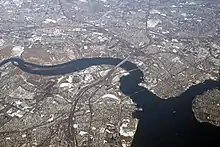
The Raritan river at its mouth at Raritan Bay, an arm of the Upper New York Bay


Crossings

Crossing Image Carries Location Coordinates

Main stem

Raritan Bay Drawbridge NJ Transit North Jersey Coast Line
Norfolk Southern Railway
CSX
40.4961°N 74.2810°W / 40.4961; -74.2810 (Raritan Bay Drawbridge)
Victory Bridge NJ 35 40.5077°N 74.2919°W / 40.5077; -74.2919 (Victory Bridge)
Edison Bridge US 9 north 40.5090°N 74.3007°W / 40.5090; -74.3007 (Edison Bridge)
Ellis S. Vieser Memorial Bridge US 9 south 40.5088°N 74.3014°W / 40.5088; -74.3014 (Ellis S. Vieser Memorial Bridge)
Driscoll Bridge Garden State Parkway 40.5093°N 74.3013°W / 40.5093; -74.3013 (Driscoll Bridge)
Basilone Bridge I-95
New Jersey Turnpike
40.4884°N 74.3963°W / 40.4884; -74.3963 (Basilone Bridge)
Morris Goodkind Bridge US 1 north 40.4927°N 74.4127°W / 40.4927; -74.4127 (Morris Goodkind Bridge)
Donald Goodkind Bridge US 1 south 40.4926°N 74.4131°W / 40.4926; -74.4131 (Donald Goodkind Bridge)
Albany Street Bridge NJ 27
County Route 514
40.4975°N 74.4377°W / 40.4975; -74.4377 (Albany Street Bridge)
Raritan River Bridge (Northeast Corridor) Amtrak Northeast Corridor
NJ Transit Northeast Corridor Line
40.5011°N 74.4409°W / 40.5011; -74.4409 (Raritan River Bridge (Northeast Corridor))
John A. Lynch Sr. Memorial Bridge NJ 18 40.5084°N 74.4586°W / 40.5084; -74.4586 (John A. Lynch Sr. Memorial Bridge)
Landing Lane Bridge County Route 609 40.5086°N 74.4638°W / 40.5086; -74.4638 (Landing Lane Bridge)
I-287 Bridge I-287 40.5397°N 74.5119°W / 40.5397; -74.5119 (I-287 Bridge)
Rail bridge (abandoned) Rail 40.5588°N 74.5240°W / 40.5588; -74.5240 (Rail bridge (abandoned))
Queen's Bridge County Route 527 40.5596°N 74.5278°W / 40.5596; -74.5278 (Queen's Bridge)
I-287 Bridge I-287 40.5542°N 74.5445°W / 40.5542; -74.5445 (I-287 Bridge)
Rail bridges Conrail Shared Assets Operations 40.5497°N 74.5687°W / 40.5497; -74.5687 (Rail bridges)
Rail bridge Conrail Shared Assets Operations 40.5518°N 74.5720°W / 40.5518; -74.5720 (Rail bridge)
Rail bridge (abandoned) Rail 40.5527°N 74.5754°W / 40.5527; -74.5754 (Rail bridge (abandoned))
Van Veghten's Bridge County Route 533 40.5553°N 74.5832°W / 40.5553; -74.5832 (Van Veghten's Bridge)
U.S. Route 206 Bridge US 206 40.5562°N 74.6159°W / 40.5562; -74.6159 (U.S. Route 206 Bridge)
Rail bridge (abandoned) Rail 40.5575°N 74.6206°W / 40.5575; -74.6206 (Rail bridge (abandoned))
Nevius Street Bridge Pedestrian Bridge 40.5646°N 74.6357°W / 40.5646; -74.6357 (Nevius Street Bridge)
John Basilone Veterans Memorial Bridge County Route 625 40.5094°N 74.7269°W / 40.5094; -74.7269 (John Basilone Veterans Memorial Bridge)

North Branch

Old York Road Bridge County Route 567 Branchburg 40.5604°N 74.7147°W / 40.5604; -74.7147 (Old York Road Bridge)
North Branch Bridge NJ 28
County Route 614
North Branch 40.6000°N 74.6737°W / 40.6000; -74.6737 (North Branch Bridge)

South Branch

Studdiford Drive Bridge Studdiford Drive South Branch 40.5468°N 74.6963°W / 40.5468; -74.6963 (Studdiford Drive Bridge)
Neshanic Station Lenticular Truss Bridge County Route 667 Neshanic Station 40.5647°N 74.6368°W / 40.5647; -74.6368 (Neshanic Station Lenticular Truss Bridge)

See also

  •  Transport portal
  •  Engineering portal
  •  New Jersey portal
This article is issued from Wikipedia. The text is licensed under Creative Commons - Attribution - Sharealike. Additional terms may apply for the media files.