Tibbie, Alabama
"Tibbie" redirects here. For 18th century Scottish woman, see Tibbie Tamson.
| Tibbie, Alabama | |
|---|---|
| Census-designated place | |
 Tibbie, Alabama | |
| Coordinates: 31°21′44″N 88°14′55″W / 31.36222°N 88.24861°WCoordinates: 31°21′44″N 88°14′55″W / 31.36222°N 88.24861°W | |
| Country | United States |
| State | Alabama |
| County | Washington |
| Area[1] | |
| • Total | 1.767 sq mi (4.58 km2) |
| • Land | 1.750 sq mi (4.53 km2) |
| • Water | 0.017 sq mi (0.04 km2) |
| Elevation | 226 ft (69 m) |
| Population (2010)[2] | |
| • Total | 41 |
| • Density | 23/sq mi (9.0/km2) |
| Time zone | Central (CST) (UTC-6) |
| • Summer (DST) | CDT (UTC-5) |
| Area code(s) | 251 |
| GNIS feature ID | 127959[3] |
Tibbie is a census-designated place and unincorporated community in Washington County, Alabama, United States. Its population was 41 as of the 2010 census.[2]
The Red Alabama Blackmouth Cur is thought to have originated in the area around Tibbie in the 1940s.[4]
History
The name Tibbie comes from a shortened form of the Choctaw word "oakibbeha". Oakibbeha means "blocks of ice therein," with okti meaning "ice" and the plural form abeha meaning "to be in".[5]
A post office first began operations under the name Tibbie in 1910.[6]
References
- ↑ "US Gazetteer files: 2010, 2000, and 1990". United States Census Bureau. 2011-02-12. Retrieved 2011-04-23.
- 1 2 "American FactFinder". United States Census Bureau. Retrieved 2011-05-14.
- ↑ "Tibbie". Geographic Names Information System. United States Geological Survey.
- ↑ Howard, Steve. "Sand Ridge Kennels". Retrieved 3 July 2015.
- ↑ Foscue, Virginia (1989). Place Names in Alabama. Tuscaloosa: The University of Alabama Press. p. 137. ISBN 0-8173-0410-X.
- ↑ "Washington County". Jim Forte Postal History. Retrieved 2 July 2015.
Municipalities and communities of Washington County, Alabama, United States | ||
|---|---|---|
| Towns | 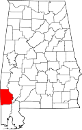 | |
| CDPs | ||
| Unincorporated communities | ||
| Ghost towns | ||
| Footnotes | ‡This populated place also has portions in an adjacent county or counties | |
This article is issued from Wikipedia - version of the 7/3/2015. The text is available under the Creative Commons Attribution/Share Alike but additional terms may apply for the media files.