Leroy, Alabama
| Leroy, Alabama | |
|---|---|
| Census-designated place | |
 Leroy, Alabama Location of Leroy in Alabama | |
| Coordinates: 31°30′17″N 87°59′05″W / 31.50472°N 87.98472°W | |
| Country | United States |
| State | Alabama |
| County | Washington |
| Area[1] | |
| • Total | 11.983 sq mi (31.04 km2) |
| • Land | 11.910 sq mi (30.85 km2) |
| • Water | 0.073 sq mi (0.19 km2) |
| Elevation[2] | 167 ft (51 m) |
| Population (2010)[3] | |
| • Total | 911 |
| • Density | 76/sq mi (29/km2) |
| Time zone | Central (CST) (UTC-6) |
| • Summer (DST) | CDT (UTC-5) |
| ZIP code | 36548 |
| Area code(s) | 251 |
| FIPS code | 01-42304 |
| GNIS feature ID | 156602[2] |
| Other names |
Dogwood Level New Canaan Possum Corner[2] |
| [4] | |
Leroy is a census-designated place located in Washington County, Alabama, around 60 miles (97 km) north of Mobile. As of the 2010 census, its population was 911.[3]
Notable people
- Sammie Coates, current NFL Wide Receiver, Pittsburgh Steelers
- Phillip Ervin, professional baseball center fielder
- Emanuel King, former NFL player
- Simmie Knox, American painter
- Kelvin Moore, former first baseman for the Oakland Athletics
References
- ↑ "US Gazetteer files: 2010, 2000, and 1990". United States Census Bureau. 2011-02-12. Retrieved 2011-04-23.
- 1 2 3 U.S. Geological Survey Geographic Names Information System: Leroy, Alabama. Retrieved on 2009-06-16.
- 1 2 "American FactFinder". United States Census Bureau. Archived from the original on September 11, 2013. Retrieved 2011-05-14.
- ↑ "Leroy AL". ZIP Code Lookup. Retrieved 2009-06-16.
Municipalities and communities of Washington County, Alabama, United States | ||
|---|---|---|
| Towns | 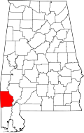 | |
| CDPs | ||
| Unincorporated communities | ||
| Ghost towns | ||
| Footnotes | ‡This populated place also has portions in an adjacent county or counties | |
This article is issued from Wikipedia - version of the 7/20/2016. The text is available under the Creative Commons Attribution/Share Alike but additional terms may apply for the media files.