York Township, Union County, Ohio
| York Township, Union County, Ohio | |
|---|---|
| Township | |
|
School at York Center | |
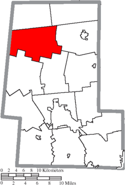 Location of York Township in Union County | |
| Coordinates: 40°24′41″N 83°27′31″W / 40.41139°N 83.45861°WCoordinates: 40°24′41″N 83°27′31″W / 40.41139°N 83.45861°W | |
| Country | United States |
| State | Ohio |
| County | Union |
| Area | |
| • Total | 37.5 sq mi (97.1 km2) |
| • Land | 37.5 sq mi (97.1 km2) |
| • Water | 0.0 sq mi (0.1 km2) |
| Elevation[1] | 1,007 ft (307 m) |
| Population (2000) | |
| • Total | 1,174 |
| • Density | 31.3/sq mi (12.1/km2) |
| Time zone | Eastern (EST) (UTC-5) |
| • Summer (DST) | EDT (UTC-4) |
| FIPS code | 39-87122[2] |
| GNIS feature ID | 1087086[1] |

York Township is one of the fourteen townships of Union County, Ohio, United States. The 2000 census found 1,174 people in the township.[3]
Geography
Located in the northwestern part of the county, it borders the following townships:
- Washington Township - north
- Jackson Township - northeast
- Claibourne Township - east
- Taylor Township - southeast
- Liberty Township - south
- Perry Township, Logan County - southwest
- Bokes Creek Township, Logan County - northwest
No municipalities are located in York Township, although it has the unincorporated communities of Somersville and York Center.
Name and history
It is one of ten York Townships statewide.[4] The township was organized in 1834.[5]
Government
The township is governed by a three-member board of trustees, who are elected in November of odd-numbered years to a four-year term beginning on the following January 1. Two are elected in the year after the presidential election and one is elected in the year before it. There is also an elected township fiscal officer,[6] who serves a four-year term beginning on April 1 of the year after the election, which is held in November of the year before the presidential election. Vacancies in the fiscal officership or on the board of trustees are filled by the remaining trustees.
References
- 1 2 "US Board on Geographic Names". United States Geological Survey. 2007-10-25. Retrieved 2008-01-31.
- ↑ "American FactFinder". United States Census Bureau. Archived from the original on September 11, 2013. Retrieved 2008-01-31.
- ↑ Union County, Ohio — Population by Places Estimates Ohio State University, 2007. Accessed 15 May 2007.
- ↑ "Detailed map of Ohio" (PDF). United States Census Bureau. 2000. Retrieved 2007-02-16.
- ↑ A.S. Mowry, C.E., Atlas of Union County, Ohio, Harris, Sutton & Hare, Philadelphia, 1877, Pg. 20.
- ↑ §503.24, §505.01, and §507.01 of the Ohio Revised Code. Accessed 4/30/2009.
External links
Municipalities and communities of Union County, Ohio, United States | ||
|---|---|---|
| Cities | 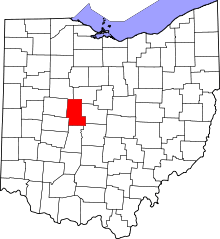 | |
| Villages | ||
| Townships | ||
| CDPs | ||
| Unincorporated communities | ||
| Ghost town | ||
| Footnotes | ‡This populated place also has portions in an adjacent county or counties | |