Yodok County
| Yodŏk County 요덕군 | |
|---|---|
| County | |
| Korean transcription(s) | |
| • Hanja | 耀德郡 |
| • McCune-Reischauer | Yodŏk kun |
| • Revised Romanization | Yodeok-gun |
| Country | North Korea |
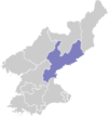
| Province | South Hamgyong Province |
| Administrative divisions | 1 ŭp, 21 ri |
| Population (1991 est.) | |
| • Total | 33,000 |
Yodŏk County is a county in South Hamgyŏng province, North Korea. Originally part of Yŏnghŭng county (now Kŭmya county), it became a separate entity as part of the 1952 reorganization of local government.
Physical features
Most of the county is mountainous. Yodŏk is traversed by the Rangrim and Puktaebong ranges. The chief river is the Ryonghŭng. The highest point is Raganbong. Roughly 90% of the county's area is forestland.
Administrative Divisions
Yodŏk county is divided into 1 ŭp (town) and 21 ri (villages):
|
|
Economy
Due to the rugged terrain, agriculture is nearly impossible. However, a few farms are tucked into the mountains, harvesting maize, soybeans, millet, wheat and barley.
Transport
Yodŏk county is served primarily by roads, but there is a single railway station on the P'yŏngra line of the Korean State Railway in Yodŏk-ŭp.
Camp
Yodŏk is the site of the Yodŏk concentration camp.
See also
External links
- (Korean) In Korean language online encyclopedias:
Coordinates: 39°36′40″N 126°50′40″E / 39.61111°N 126.84444°E