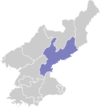
Sinhung County
| Sinhung County 신흥군 | |
|---|---|
| County | |
| Korean transcription(s) | |
| • Hanja | 新興郡 |
| • McCune-Reischauer | Sinhŭng kun |
| • Revised Romanization | Sinheung-gun |
| Country | North Korea |
| Province | South Hamgyong Province |
| Administrative divisions | 1 ŭp, 3 workers' districts, 21 ri |
| Population (1987 est.) | |
| • Total | 124,000 |
Sinhŭng County is a mountainous county in South Hamgyŏng province, North Korea.
Geography
It is traversed by the Hamgyŏng and Palbong ranges. The highest point is Chailbong. There are also lowland plains, where the temperatures are quite different from the mountains. The chief streams are the Sangch'ŏn and Pujŏn Rivers.
Administrative divisions
Sinhŭng county is divided into 1 ŭp (town), 3 rodongjagu (workers' districts) and 21 ri (villages):
|
|
Economy
Agriculture dominates the local economy. In the mountain regions, the crops include oats, potatoes, millet, and barnyard millet. In the fertile areas in the south, rice is also grown. Lumbering and hydropower are also part of the local economy; relatively little mining takes place.
Ryu Kyong-su Tank Factory is located in the area.
Transportation
Sinhŭng is served by road and rail, and lies on the Sinhŭng line of the Korean State Railway.
See also
External links
- Sinhung Area Revolutionary Battle Sites picture album at Naenara
- (Korean) In Korean language online encyclopedias:
