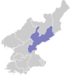
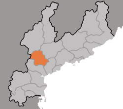
Yonggwang County
| Yŏnggwang County 영광군 | |
|---|---|
| County | |
| Korean transcription(s) | |
| • Hanja | 榮光郡 |
| • McCune–Reischauer | Yŏnggwang-gun |
| • Revised Romanization | Yeonggwang-gun |
 | |
| Country | North Korea |
| Province | South Hamgyong |
| Administrative divisions | 1 ŭp, 1 workers' district, 24 ri |
| Population (2008) | |
| • Total | 103,532 [1] |
Yŏnggwang County is a county in South Hamgyŏng province, North Korea.
Geography
The county is primarily mountainous, and is traversed by the Pujŏllyŏng Mountains (부전령산맥). However, there are areas of rolling and level ground, especially along the Sŏngch'ŏn River (성천강). Other significant streams include the Hŭngrim River (흑림강), Chadongch'ŏn (자동천), Ch'ŏnbulsanch'ŏn (천불산천), and Kigokch'ŏn (기곡천). Roughly 80% of the county is occupied by forestland. The highest point is Mataesan.
Administrative Divisions
Yŏnggwang County is divided into 1 ŭp (town), 1 rodongjagu (workers' districts) and 24 ri (villages):
|
|
History
It was originally part of Hamju County, from which it was separated in a general reorganization of local government in 1952. Formerly known as Oro, it was named in 1981 after Yŏnggwang, glory. It is the site of one of the steles erected by Chinhŭng of Silla in the 6th century.
Economy
Despite the rugged terrain, there is agriculture in Yŏnggwang. Local crops include maize, rice, soybeans, wheat, and barley. Small-scale orchards and livestock operations also exist. There are deposits of coal and gold. In addition, hydroelectric power is produced in the region.
Transportation
The Sinhŭng and Changjin lines of the Korean State Railway pass through the county, which is also served by roads.
See also
References
- ↑ DPR Korean Central Bureau of Statistics: 2008 Population Census Archived May 14, 2011, at the Wayback Machine. (Population 2008, published in 2009)
External links
- (Korean) In Korean language online encyclopedias: