Woodhaven Boulevard (IND Queens Boulevard Line)
| Woodhaven Boulevard | |||||||||||
|---|---|---|---|---|---|---|---|---|---|---|---|
| New York City Subway rapid transit station | |||||||||||
|
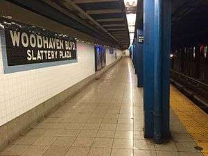
Forest Hills- and Jamaica-bound platform | |||||||||||
| Station statistics | |||||||||||
| Address |
Woodhaven Boulevard & Queens Boulevard Queens, NY 11373 | ||||||||||
| Borough | Queens | ||||||||||
| Locale | Elmhurst | ||||||||||
| Coordinates | 40°44′00″N 73°52′13″W / 40.73347°N 73.870397°WCoordinates: 40°44′00″N 73°52′13″W / 40.73347°N 73.870397°W | ||||||||||
| Division | B (IND) | ||||||||||
| Line | IND Queens Boulevard Line | ||||||||||
| Services |
E M R | ||||||||||
| Transit connections |
| ||||||||||
| Structure | Underground | ||||||||||
| Platforms | 2 side platforms | ||||||||||
| Tracks | 4 | ||||||||||
| Other information | |||||||||||
| Opened | December 31, 1936 | ||||||||||
| Wireless service |
| ||||||||||
| Former/other names |
Woodhaven Boulevard–Slattery Plaza Woodhaven Boulevard–Queens Mall | ||||||||||
| Traffic | |||||||||||
| Passengers (2015) |
7,120,037[3] | ||||||||||
| Rank | 60 out of 422 | ||||||||||
| Station succession | |||||||||||
| Next north |
63rd Drive–Rego Park: E | ||||||||||
| Next south |
Grand Avenue–Newtown: E | ||||||||||
| |||||||||||
| |||||||||||


Woodhaven Boulevard is a local station on the IND Queens Boulevard Line of the New York City Subway, consisting of four tracks. Located in the Elmhurst neighborhood of Queens, it is served by the R train at all times except nights, when the E train takes over service. The M train provides additional service here on weekdays except nights. The station serves the adjacent Queens Center Mall, as well as numerous bus lines.
History
The Queens Boulevard Line was one of the first lines built by the city-owned Independent Subway System (IND),[4][5][6] and stretches between the IND Eighth Avenue Line in Manhattan and 179th Street and Hillside Avenue in Jamaica, Queens.[4][6][7] The Queens Boulevard Line was in part financed by a Public Works Administration (PWA) loan and grant of $25,000,000.[8]
During the station's construction, the main road of Queens Boulevard was depressed into underpasses at the intersections with Woodhaven Boulevard and Horace Harding Boulevard (also known as Nassau Boulevard). The easternmost underpass now carries Queens Boulevard below the Long Island Expressway (LIE), which replaced Horace Harding Boulevard.[9] On December 31, 1936, the IND Queens Boulevard Line was extended by eight stops, and 3.5 miles (5.6 km), from its previous terminus at Roosevelt Avenue to Union Turnpike, and the Woodhaven Boulevard station opened as part of this extension.[10][11][12][13][14][15]
The station was originally named "Woodhaven Blvd–Slattery Plaza", after Slattery Plaza, the area where four main Queens thoroughfares (Eliot Avenue and Horace Harding, Woodhaven, and Queens Boulevards) intersected. The plaza, which no longer exists, featured several "mom-and-pop" small businesses.[16] The plaza and subway station were named after Colonel John R. Slattery, former Transportation Board chief engineer who died in 1932 while supervising the construction of the IND Eighth Avenue Line.[16] The construction of the LIE along the Horace Harding corridor in the 1950s caused Slattery Plaza to be demolished,[13][17][18][19] although the name tablets retained the original name even after the plaza's demolition.[16][17][18][19]
Queens Center Mall first opened in 1973,[20] but the name convention on subway maps was not in use until the mid-to-late 1980s.[lower-alpha 1] The station became dilapidated by the 1980s due to lack of maintenance over the years, and in 1981, the MTA listed the station among the 69 most deteriorated stations in the subway system.[21] The station was also heavily used, serving 15,000 passengers per weekday by 1993.[22] In 1993, the Woodhaven Boulevard station began a three-year renovation project as part of a general refurbishment of seventy New York City Subway stations. The refurbishment added a new station agent booth, as well as replaced platform tiles, staircase components, and lighting; added new signs and safety treads on the platform edges; and restored the station's restrooms.[22][23] After the renovation, the station retained the now out-of-date "Woodhaven Blvd–Slattery Plaza" name tablets.[16][17][18][19]
Station layout
| G | Street Level | Exit/Entrance |
| M | Mezzanine | Fare control, station agent, MetroCard vending machines |
| P Platform level |
Side platform, doors will open on the right | |
| Southbound local | ← ← ← | |
| Southbound express | ← | |
| Northbound express | → | |
| Northbound local | → → | |
| Side platform, doors will open on the right | ||
Built as a local station, the station was constructed with bellmouth provisions to allow conversion into an express station. A close observation of both ends of this station reveals that the tunnel wall extends outward to allow space for the two side platforms to be replaced with island platforms, with the local tracks taking the side platforms' place.[24] The station would have accommodated a major system expansion, with additional service coming from the Roosevelt Avenue Terminal station and the former LIRR Rockaway Line.[25][26] Requests to convert the station were also put forward by the local community shortly after the station opened, due to heavy bus traffic feeding into the station and overcrowding at the Roosevelt Avenue express stop.[27][28]
The name tablets on this station still retain the original name of Woodhaven Boulevard–Slattery Plaza.[16][17][18][19] The tilework in this station consists of blue bands with a black border,[29] similar to the tilework found at the Elmhurst Avenue stop, two stations west.[30]

The station's full-length mezzanine allows crossover from any of the station's four staircases from each platform, with a total of eight staircases from the mezzanine to platform level. There is no direct indoor access to the Queens Center Mall's entrance at the northwest corner of Queens Boulevard and 59th Avenue from the mezzanine.[31]
The 1996 artwork here is called In Memory of The Lost Battalion by Pablo Tauler. It uses nine support beams in the station's mezzanine wrapped in different materials, including stainless steel, to honor the soldiers who served in the 77th Infantry Division during World War I.[32]
Entrances and exits
The full-time side at the west end of the mezzanine has three street stairs. One leads to the northeast corner of Queens Boulevard and 59th Avenue, the closest to the mall. The other two staircases are through a long passageway to both southern corners of Queens Boulevard and Woodhaven Boulevard, acting as a pedestrian underpass outside of fare control.[9][31][33][34] There is an entrance to the southeast corner of Woodhaven and Queens Boulevards that, as a result of the construction of the Long Island Expressway in the mid-1950s, leads only to two entrance ramps to the expressway, with no continuous sidewalk leading to the entrance.[33][34][35]
The part-time portion at the former Horace Harding Boulevard on the east end has a closed and removed booth and one street stair to the north side of Queens Boulevard at 92nd Street. This entrance abuts two expressway ramps and leads to the former Horace Harding Boulevard, now replaced by the LIE exit ramp.[31][33][34][35] This exit still has a directional mosaic pointing to it, listing the exit as 60th Avenue and 92nd Street on the north side of Queens Boulevard.[35] The construction of the Long Island Expressway removed this intersection.[31][33][34]
Bus service

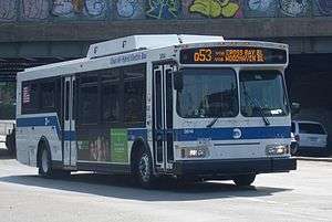
The station and the nearby Queens Center Mall are served by nine local MTA Regional Bus Operations routes and two express bus routes. Three of the four Woodhaven Boulevard bus lines (Q11, Q21, Q52 Limited) terminate at the station, with the Q53 Limited bus continuing westward towards the Woodside - 61st Street Station. Except for the Q88, Rego Park-bound Q59, Jamaica-bound Q60, and Corona-bound Q38, all northbound buses stop at the mall entrance, while all southbound buses as well as the QM10 and QM11 express buses stop at Hoffman Drive adjacent to Hoffman Park. The Q88 terminates at 92nd Street, in between the two halves of the mall.[31][36]
| Route | Operator | Stop location | North/West Terminal | South/East Terminal | via | notes |
|---|---|---|---|---|---|---|
| Local Bus Routes | ||||||
| MTA Bus | Queens Boulevard (northbound); Hoffman Drive (southbound) | Woodhaven Boulevard | Old Howard Beach or Hamilton Beach | Woodhaven and Cross Bay Boulevards | ||
| Howard Beach | Woodhaven and Cross Bay Boulevards, 155th Avenue, 157th Avenue | |||||
| Jackson Heights (82nd Street Station) | Glendale | 80th Street, Dry Harbor Road, 90th/92nd Streets | ||||
| 59th Avenue; Hoffman Drive | Corona (60th Avenue and Otis Avenue) | Rego Park (62nd Drive and 108th Street) | Eliot Avenue (Corona to Middle Village), Penelope Avenue and 63rd Drive (Middle Village to Rego Park) | Via Middle Village–Metropolitan Avenue Station | ||
| Queens Boulevard (northbound); Hoffman Drive (southbound) | Woodhaven Boulevard | Arverne By The Sea (Beach 67th Street Station) | Broadway and Queens Boulevard (Q53) Woodhaven and Cross Bay Boulevards Rockaway Beach Boulevard |
Limited Stop Service | ||
| Woodside (61st Street Station) | Rockaway Park (Beach 116th Street Station) | |||||
| NYCT | Queens Boulevard | Williamsburg, Brooklyn | Rego Park (63rd Drive Station) | Grand Street and Grand Avenue | ||
| MTA Bus | East Midtown, Manhattan | South Jamaica | Queensboro Bridge, Queens Boulevard, Sutphin Boulevard | |||
| NYCT | 92nd Street | Queens Village (Queens Village LIRR Station) | Horace Harding Expressway, 188th Street, 73rd Avenue, Springfield Boulevard | |||
| Express Bus Routes | ||||||
| MTA Bus | Woodhaven Boulevard (near Hoffman Drive) | Midtown Manhattan | Rego Park / Elmhurst Loop (Drop-off Only) | 3rd or 6th Avenue | ||
| Downtown Manhattan | Downtown Loop | |||||
Notes
- ↑ According to scans of 1980s subway maps:
- "1983 Subway Map". New York City Transit Authority. 1983. Retrieved 2016-07-10.
Woodhaven Blvd–Slattery Plaza
- "1987 Subway Map". New York City Transit Authority. 1987. Retrieved 2016-07-10.
Woodhaven Blvd–Queens Center
- "1983 Subway Map". New York City Transit Authority. 1983. Retrieved 2016-07-10.
References
- ↑ "NYC Subway Wireless – Active Stations". Transit Wireless Wifi. Retrieved 2016-05-18.
- ↑ More Subway Stations in Manhattan, Bronx in Line to Get Online, mta.info (March 25, 2015). "The first two phases included stations in Midtown Manhattan and all underground stations in Queens with the exception of the 7 Main St terminal."
- ↑ "Facts and Figures: Annual Subway Ridership". Metropolitan Transportation Authority. Retrieved 2016-04-19.
- 1 2 Duffus, R.L. (September 22, 1929). "OUR GREAT SUBWAY NETWORK SPREADS WIDER; New Plans of Board of Transportation Involve the Building of More Than One Hundred Miles of Additional Rapid Transit Routes for New York". The New York Times. Retrieved 19 August 2015.
- ↑ "QUEENS SUBWAY WORK AHEAD OF SCHEDULE: Completion Will Lead to Big Apartrnent Building, Says William C. Speers.". The New York Times. April 7, 1929. Retrieved 1 September 2015.
- 1 2 "Queens Lauded as Best Boro By Chamber Chief". Brooklyn Daily Eagle. September 23, 1929. p. 40. Retrieved 4 October 2015 – via Newspapers.com.
- ↑ New York Times, New Subway Routes in Hylan Program to Cost $186,046,000, March 21, 1925, page 1
- ↑ "TEST TRAINS RUNNING IN QUEENS SUBWAY; Switch and Signal Equipment of New Independent Line Is Being Checked.". The New York Times. 1936-12-20. ISSN 0362-4331. Retrieved 2016-04-26.
- 1 2 "PLANS ARE CHANGED FOR QUEENS SUBWAY: Traffic Crossings at Nassau and Woodhaven Boulevards Altered to Avoid Congestion. VIADUCT PROJECT DROPPED Main Driveway to Be Depressed, Side Routes to Be at Grade-- New Bids Due Soon. How Plans Were Changed. Elimination Plans Received.". The New York Times. June 22, 1930. Retrieved 1 September 2015.
- ↑ "NEW RETAIL AREA IN QUEENS BOROUGH; Sees Roosevelt Avenue Subway Station as Great Shopping Centre. ADVANTAGES POINTED OUT Accessibility to Many Home Communities Assures Potential Market.". The New York Times. 1933-07-09. ISSN 0362-4331. Retrieved 2016-04-26.
- ↑ "Reproduction Poster of Extension to Union Turnpike – Kew Gardens". Flickr – Photo Sharing!. Retrieved 2016-04-26.
- ↑ Roger P. Roess; Gene Sansone (23 August 2012). The Wheels That Drove New York: A History of the New York City Transit System. Springer Science & Business Media. pp. 416–417. ISBN 978-3-642-30484-2.
- 1 2 "PWA Party Views New Subway Link: Queens Section to Be Opened Tomorrow Is Inspected by Tuttle and Others". nytimes.com. The New York Times. December 30, 1936. Retrieved 27 June 2015.
- ↑ "CITY SUBWAY OPENS QUEENS LINK TODAY; Extension Brings Kew Gardens Within 36 Minutes of 42d St. on Frequent Trains.". The New York Times. 1936-12-31. ISSN 0362-4331. Retrieved 2016-04-26.
- ↑ "OPENING MOVED UP FOR NEW SUBWAY; Traffic to Be Started on the Extension of City's Line to Kew Gardens on Thursday. EIGHT STATIONS ARE ADDED La Guardia and Official Party Will Inspect New Queens Branch on Wednesday.". The New York Times. 1936-12-26. ISSN 0362-4331. Retrieved 2016-04-26.
- 1 2 3 4 5 Wilkinson, Christina; Walsh, Kevin (5 March 2006). "REGO PARK, Queens". Forgotten NY. Retrieved 18 August 2015.
- 1 2 3 4 Schneider, Daniel B. (October 15, 2000). "F.Y.I.". nytimes.com. The New York Times. Retrieved 27 June 2015.
- 1 2 3 4 Karni, Annie (October 7, 2012). "Subway stations retain signs listing places and streets that no longer exist". nypost.com. New York Post. Retrieved 27 June 2015.
- 1 2 3 4 Walsh, Kevin (July 29, 2014). "Ely Around in Queens". queens.brownstoner.com. Blank Slate Factory, Inc. Retrieved 27 June 2015.
- ↑ Siwolop, Sana (2004-03-03). "COMMERCIAL REAL ESTATE: REGIONAL MARKET -- Queens; Renovations And Renewal For a Mall". The New York Times. Retrieved 2016-07-11.
Built in 1973
- ↑ Gargan, Edward A. (June 11, 1981). "AGENCY LISTS ITS 69 MOST DETERIORATED SUBWAY STATIONS". The New York Times. Retrieved 13 August 2016.
- 1 2 Hernandez, Raymond (1993-11-21). "NEIGHBORHOOD REPORT: ELMHURST/EAST ELMHURST; An Offer of Help for the Tired Woodhaven Blvd. Station". The New York Times. Retrieved 2016-07-11.
- ↑ "The New Woodhaven Blvd Station Woodhaven Blvd station Built in the 30s Renewed for the 90s" (pamphlet). Retrieved 2016-07-10.
- ↑ "The Express Stop That Never Was". ltvsquad.com. LTV Squad. June 2, 2015. Retrieved 27 June 2015.
- ↑ Kihss, Peter (April 13, 1967). "3 Routes Proposed to Aid Growing Queens Areas". nytimes.com. The New York Times. Retrieved 27 June 2015.
- ↑ "Adding City Transit Line to Rockaways Is Chamber '47 Goal". Brooklyn Daily Eagle. January 2, 1947. p. 4. Retrieved 10 October 2015 – via Newspapers.com.
- ↑ "Queens Bus Riders Join in Campaign For Station Shelters: Protection Is Sought At Slattery Place, Plus an Express Stop". Brooklyn Daily Eagle. December 15, 1940. p. 10. Retrieved 10 October 2015 – via Newspapers.com.
- ↑ "Express Station Plea Is Weighed". Brooklyn Daily Eagle. October 20, 1940. p. 8. Retrieved 10 October 2015 – via Newspapers.com.
- ↑ Cox, Jeremiah. "Woodhaven Blvd". The Subway Nut. Retrieved 2016-07-11.
- ↑ "IND Queens Boulevard Line: Woodhaven Boulevard-Queens Mall". www.nycsubway.org. Retrieved 2016-07-11.
- 1 2 3 4 5 "MTA Neighborhood Maps: Forest Hills" (PDF). mta.info. Metropolitan Transportation Authority. 2015. Retrieved 6 July 2015.
- ↑ "MTA Arts & Design: Woodhaven Boulevard". Metropolitan Transportation Authority. Archived from the original on 2015-09-23. Retrieved 23 September 2015.
- 1 2 3 4 "SUBWAY-SIDEWALK INTERFACE PROJECT TECHNICAL MEMORANDUM IV ISSUES AND OPPORTUNITIES" (PDF). transalt.org. New York City Department of City Planning,. November 2000. Retrieved 6 December 2015.
- 1 2 3 4 "SUBWAY-SIDEWALK INTERFACE PROJECT: WOODHAVEN BOULEVARD STATION" (PDF). transalt.org. Transportation Alternatives, City of New York, New York City Department of City Planning, New York City Department of Transportation. 2000.
- 1 2 3 Cox, Jeremiah. "Woodhaven Blvd (G,R,V)". The SubwayNut. Retrieved 2016-07-01.
- ↑ "Queens Bus Map" (PDF). Metropolitan Transportation Authority. 2016. Retrieved 2016-07-10.
External links
| Wikimedia Commons has media related to Woodhaven Boulevard (IND Queens Boulevard Line). |
- nycsubway.org – IND Queens Boulevard Line: Woodhaven Boulevard/Queens Mall
- Station Reporter — R Train
- Station Reporter — M Train
- MTA's Arts For Transit — Woodhaven Boulevard (IND Queens Boulevard Line)
- The Subway Nut — Woodhaven Boulevard Pictures
- Woodhaven Boulevard entrance from Google Maps Street View
- Horace Harding Boulevard (Long Island Expressway) entrance from Google Maps Street View