Woodbine, Georgia
| Woodbine, Georgia | ||
|---|---|---|
| City | ||
|
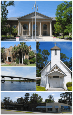
Top, left to right: Camden County Courthouse, Old Camden County Courthouse, Satilla River, St. Mark's Episcopal Church, Woodbine Historic District | ||
| ||
| Motto: "Cherish Yesterday, Embrace Today, Prepare for Tomorrow"[1] | ||
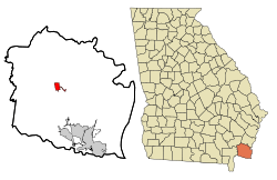 Location in Camden County and the state of Georgia | ||
| Coordinates: 30°57′43″N 81°43′12″W / 30.96194°N 81.72000°WCoordinates: 30°57′43″N 81°43′12″W / 30.96194°N 81.72000°W | ||
| Country | United States | |
| State | Georgia | |
| County | Camden | |
| Area | ||
| • Total | 2.6 sq mi (6.7 km2) | |
| • Land | 2.5 sq mi (6.5 km2) | |
| • Water | 0.08 sq mi (0.2 km2) | |
| Elevation | 13 ft (4 m) | |
| Population (2010) | ||
| • Total | 1,412 | |
| • Density | 563/sq mi (217.4/km2) | |
| Time zone | Eastern (EST) (UTC-5) | |
| • Summer (DST) | EDT (UTC-4) | |
| ZIP code | 31569 | |
| Area code(s) | 912 | |
| FIPS code | 13-83868[2] | |
| GNIS feature ID | 0325526[3] | |
| Website |
woodbinegeorgia | |

Woodbine is a city in, and the county seat of, Camden County, Georgia, United States, an original county established when the state constitution was adopted in 1777.[4][5] The population was 1,412 at the 2010 census.[6]
The East Coast Greenway, a 3,000 mile long system of trails connecting Maine to Florida, runs along the Woodbine Riverwalk.
History
Records in 1765 show that John Brown, John McGillvary, William Struthers and William Trowin petitioned English authorities for 1,400 acres (570 ha) south of the Satilla River. They were granted the land named Pile's Bluff, which historians believe to be near Woodbine.[4]
A tract of land was granted to Elijah Clarke by the state in 1808. It became known as the Woodbine Plantation. John Bailey purchased it in 1835 and held it through the Civil War, during which the house was burned by Union troops. James King Bedell acquired the property, constructed a new house, and restored the plantation. The railroad entered Camden County in 1893, and Bedell sold a right-of-way across his land, but required that the first rail community be named "Woodbine".[4]
Woodbine was incorporated as a town on August 13, 1908,[7] and the word is the common English name for the honeysuckle, Lonicera.[7][8] The town grew more after the Atlantic Coastal Highway was constructed during 1927 and the county seat relocated there the following year. Woodbine re-incorporated as a city in 1953.[4]
Geography
The city is situated near the center of the county, which is located in the southeast corner of the state near the Florida border. It is located on the south bank of the Satilla River near the head of its tidal extent. U.S. Route 17 (Ocean Highway) passes through the center of the city, leading northeast 29 miles (47 km) to Brunswick and south 11 miles (18 km) to Kingsland. The city has extended its borders 2 miles (3 km) east along 10th Street to reach Interstate 95 at its Exit 14.
Woodbine is located at 30°57′43″N 81°43′12″W / 30.96194°N 81.72000°W (30.961869, -81.720017).[9]
According to the United States Census Bureau, the city has a total area of 2.6 square miles (6.7 km2), of which 2.5 square miles (6.5 km2) is land and 0.08 square miles (0.2 km2), or 2.37%, is water.[6]
Demographics
| Historical population | |||
|---|---|---|---|
| Census | Pop. | %± | |
| 1910 | 155 | — | |
| 1920 | 172 | 11.0% | |
| 1930 | 335 | 94.8% | |
| 1940 | 373 | 11.3% | |
| 1950 | 750 | 101.1% | |
| 1960 | 845 | 12.7% | |
| 1970 | 1,002 | 18.6% | |
| 1980 | 910 | −9.2% | |
| 1990 | 1,212 | 33.2% | |
| 2000 | 1,218 | 0.5% | |
| 2010 | 1,412 | 15.9% | |
| Est. 2015 | 1,285 | [10] | −9.0% |
As of the census[2] of 2000, there were 1,218 people, 423 households, and 299 families residing in the city. The population density was 543.1 people per square mile (209.9/km²). There were 520 housing units at an average density of 231.9 per square mile (89.6/km²). The racial makeup of the city was 53.61% White, 43.84% African American, 0.33% Native American, 0.25% Asian, 0.90% from other races, and 1.07% from two or more races. Hispanic or Latino of any race were 2.30% of the population.
There were 423 households out of which 37.8% had children under the age of 18 living with them, 45.2% were married couples living together, 20.8% had a female householder with no husband present, and 29.1% were non-families. 24.3% of all households were made up of individuals and 9.2% had someone living alone who was 65 years of age or older. The average household size was 2.66 and the average family size was 3.18.
In the city the population was spread out with 30.0% under the age of 18, 10.1% from 18 to 24, 29.8% from 25 to 44, 20.5% from 45 to 64, and 9.5% who were 65 years of age or older. The median age was 33 years. For every 100 females there were 98.0 males. For every 100 females age 18 and over, there were 100.9 males.
The median income for a household in the city was $34,632, and the median income for a family was $39,688. Males had a median income of $30,192 versus $22,273 for females. The per capita income for the city was $13,709. About 15.5% of families and 18.7% of the population were below the poverty line, including 18.9% of those under age 18 and 22.1% of those age 65 or over.
Climate
| Climate data for Woodbine, Georgia | |||||||||||||
|---|---|---|---|---|---|---|---|---|---|---|---|---|---|
| Month | Jan | Feb | Mar | Apr | May | Jun | Jul | Aug | Sep | Oct | Nov | Dec | Year |
| Average high °F (°C) | 61.3 (16.3) |
65.7 (18.7) |
71.9 (22.2) |
78.6 (25.9) |
84.9 (29.4) |
89.4 (31.9) |
91.8 (33.2) |
89.3 (31.8) |
86.0 (30) |
78.9 (26.1) |
71.7 (22.1) |
64.6 (18.1) |
77.9 (25.5) |
| Daily mean °F (°C) | 49.0 (9.4) |
53.5 (11.9) |
59.2 (15.1) |
65.1 (18.4) |
72.3 (22.4) |
78.6 (25.9) |
81.4 (27.4) |
80.1 (26.7) |
76.9 (24.9) |
67.7 (19.8) |
59.8 (15.4) |
54.4 (12.4) |
66.4 (19.1) |
| Average low °F (°C) | 36.6 (2.6) |
41.3 (5.2) |
46.6 (8.1) |
51.7 (10.9) |
59.7 (15.4) |
67.9 (19.9) |
71.1 (21.7) |
70.9 (21.6) |
67.8 (19.9) |
56.5 (13.6) |
47.9 (8.8) |
40.2 (4.6) |
54.9 (12.7) |
| Average rainfall inches (mm) | 3.8 (97) |
3.9 (99) |
3.9 (99) |
3.5 (89) |
2.2 (56) |
6.7 (170) |
6.2 (157) |
8.5 (216) |
5.6 (142) |
4.6 (117) |
2.3 (58) |
2.6 (66) |
54 (1,372) |
| Average precipitation days | 7.2 | 7.7 | 7.0 | 5.0 | 5.8 | 12.0 | 12.4 | 13.5 | 11.4 | 7.0 | 4.9 | 6.7 | 100.6 |
| Source: [12] | |||||||||||||
See also
References
- ↑ "City of Woodbine Georgia Website". City of Woodbine Georgia Website. Retrieved September 6, 2012.
- 1 2 "American FactFinder". United States Census Bureau. Retrieved 2008-01-31.
- ↑ "US Board on Geographic Names". United States Geological Survey. 2007-10-25. Retrieved 2008-01-31.
- 1 2 3 4 "Woodbine History". City of Woodbine, Georgia. Retrieved July 22, 2013.
- ↑ "Woodbine". Georgia Gov. Retrieved September 6, 2012.
- 1 2 "Geographic Identifiers: 2010 Demographic Profile Data (G001): Woodbine city, Georgia". U.S. Census Bureau, American Factfinder. Retrieved July 17, 2014.
- 1 2 "Woodbine". Georgia Department of Community Affairs. Retrieved September 6, 2012.
- ↑ "Profile for Woodbine, Georgia, GA". ePodunk. Retrieved September 6, 2012.
- ↑ "US Gazetteer files: 2010, 2000, and 1990". United States Census Bureau. 2011-02-12. Retrieved 2011-04-23.
- ↑ "Annual Estimates of the Resident Population for Incorporated Places: April 1, 2010 to July 1, 2015". Retrieved July 2, 2016.
- ↑ "Census of Population and Housing". Census.gov. Retrieved June 4, 2015.
- ↑ "Woodbine Georgia Averages By Weatherbase". Weatherbase. Retrieved July 13, 2016.
External links
| Wikimedia Commons has media related to Woodbine, Georgia. |
- City of Woodbine official website
- Woodbine at City-Data.com
Municipalities and communities of Camden County, Georgia, United States | ||
|---|---|---|
| Cities | 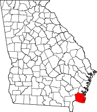 | |
| CDP | ||
| Unincorporated communities | ||