Winsted, Minnesota
| Winsted, Minnesota | |
|---|---|
| City | |
|
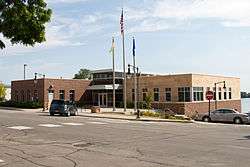
The new Winsted City Hall | |
 Location of Winsted within McLeod County, Minnesota | |
| Coordinates: 44°57′53″N 94°2′51″W / 44.96472°N 94.04750°W | |
| Country | United States |
| State | Minnesota |
| County | McLeod |
| Area[1] | |
| • Total | 1.92 sq mi (4.97 km2) |
| • Land | 1.91 sq mi (4.95 km2) |
| • Water | 0.01 sq mi (0.03 km2) |
| Elevation | 1,024 ft (312 m) |
| Population (2010)[2] | |
| • Total | 2,355 |
| • Estimate (2012[3]) | 2,312 |
| • Density | 1,233.0/sq mi (476.1/km2) |
| Time zone | Central (CST) (UTC-6) |
| • Summer (DST) | CDT (UTC-5) |
| ZIP code | 55395 |
| Area code(s) | 320 |
| FIPS code | 27-71086[4] |
| GNIS feature ID | 0654275[5] |
| Website | winsted.mn.us |
Winsted is a city in McLeod County, Minnesota, United States. The population was 2,355 at the 2010 census.[6]
History
A post office called Winsted has been in operation since 1858.[7] The city was named after Winsted, Connecticut.[8]
Geography
According to the United States Census Bureau, the city has a total area of 1.92 square miles (4.97 km2), of which 1.91 square miles (4.95 km2) is land and 0.01 square miles (0.03 km2) is water.[1] McLeod County Roads 1 and 6 are two of the main routes in the community.
Demographics
| Historical population | |||
|---|---|---|---|
| Census | Pop. | %± | |
| 1880 | 140 | — | |
| 1890 | 267 | 90.7% | |
| 1900 | 281 | 5.2% | |
| 1910 | 296 | 5.3% | |
| 1920 | 434 | 46.6% | |
| 1930 | 482 | 11.1% | |
| 1940 | 660 | 36.9% | |
| 1950 | 941 | 42.6% | |
| 1960 | 1,163 | 23.6% | |
| 1970 | 1,266 | 8.9% | |
| 1980 | 1,522 | 20.2% | |
| 1990 | 1,581 | 3.9% | |
| 2000 | 2,094 | 32.4% | |
| 2010 | 2,355 | 12.5% | |
| Est. 2015 | 2,296 | [9] | −2.5% |
2010 census
As of the census[2] of 2010, there were 2,355 people, 947 households, and 596 families residing in the city. The population density was 1,233.0 inhabitants per square mile (476.1/km2). There were 1,017 housing units at an average density of 532.5 per square mile (205.6/km2). The racial makeup of the city was 97.5% White, 0.5% African American, 0.3% Native American, 0.1% Asian, 0.1% Pacific Islander, 0.9% from other races, and 0.6% from two or more races. Hispanic or Latino of any race were 1.8% of the population.
There were 947 households of which 33.4% had children under the age of 18 living with them, 46.9% were married couples living together, 9.9% had a female householder with no husband present, 6.1% had a male householder with no wife present, and 37.1% were non-families. 30.4% of all households were made up of individuals and 11.6% had someone living alone who was 65 years of age or older. The average household size was 2.41 and the average family size was 3.03.
The median age in the city was 36.3 years. 26.1% of residents were under the age of 18; 7.2% were between the ages of 18 and 24; 27.9% were from 25 to 44; 23.6% were from 45 to 64; and 15.2% were 65 years of age or older. The gender makeup of the city was 49.3% male and 50.7% female.
Compared with the 2000 census, the 2010 census showed an increase of 261 individuals, and a .92% increase in diversity.
Culture
Winsted has both a winter and summer town festival. The Winsted Winter Festival features a lighted parade as well as various other activities. The Winsted Summer Festival features a parade, street dance, a sand volleyball tournament, the crowning of Miss Winsted, and various other activities. Winsted is also home to Winstock Country Music Festival. The proceeds from the music festival support the Holy Trinity Catholic school system.
Government and politics
- Mayor: Steve Stotko
- Council: Tom Ollig, Bonnie Quast, Max Fasching and George Schulenberg
- Administrator: Clay Wilfahrt
- Clerk Treasurer: Deb Boelter
- Police Chief: Justin Heldt
- Fire chief: Chad Engel
- Maintenance Leads: Dave Meyer and Jamie Stotko
- City Attorney: Francis Eggert[11]
Education
There are two school systems in Winsted. The Howard Lake–Waverly–Winsted school district [12] is the public school system which operates Winsted Elementary. The Catholic school system is made up of Holy Trinity High School, Holy Trinity Elementary School, and Tiny Trojans pre-school.[13]
The Winsted Public Library is part of the Pioneerland Library System.[14]
See also
References
- 1 2 "US Gazetteer files 2010". United States Census Bureau. Retrieved 2012-11-13.
- 1 2 "American FactFinder". United States Census Bureau. Retrieved 2012-11-13.
- ↑ "Population Estimates". United States Census Bureau. Retrieved 2013-05-28.
- ↑ "American FactFinder". United States Census Bureau. Retrieved 2008-01-31.
- ↑ "US Board on Geographic Names". United States Geological Survey. 2007-10-25. Retrieved 2008-01-31.
- ↑ "2010 Census Redistricting Data (Public Law 94-171) Summary File". American FactFinder. United States Census Bureau. Retrieved 27 April 2011.
- ↑ "McLeod County". Jim Forte Postal History. Retrieved 19 July 2015.
- ↑ Upham, Warren (1920). Minnesota Geographic Names: Their Origin and Historic Significance. Minnesota Historical Society. p. 318.
- ↑ "Annual Estimates of the Resident Population for Incorporated Places: April 1, 2010 to July 1, 2015". Retrieved July 2, 2016.
- ↑ "Census of Population and Housing". Census.gov. Retrieved June 4, 2015.
- ↑ http://www.winsted.mn.us
- ↑ HL-W-W District Home Page
- ↑ Holy Trinity - Holy Trinity's Home Page
- ↑ PLS Home Page.
External links
Municipalities and communities of McLeod County, Minnesota, United States | ||
|---|---|---|
| Cities | 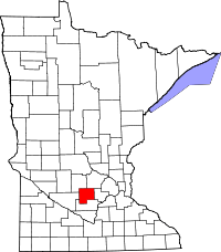 | |
| Townships | ||
| Unincorporated communities | ||
Coordinates: 44°57′50″N 94°02′51″W / 44.96389°N 94.04750°W