Windmill Hill Historic District
The Windmill Hill Historic District is a historic district encompassing a large rural landscape in Jamestown, Rhode Island. It is bounded on the north by Eldred Avenue, on the east by East Shore Road, on the south by Great Creek, and on the west by Narragansett Bay. The area's historical resources included six farmsteads, as well as the Quaker Meetinghouse, the Jamestown Windmill, and its associated miller's house and barn. The area is predominantly rolling hills with open pastureland and forest.[2] The district was listed on the National Register of Historic Places in 1978.[1] The area is also rich in prehistoric evidence of Native American occupation, which is the subject of the Jamestown Archeological District listing on the National Register.[2]
See also
References
External links
- Historic American Buildings Survey (HABS) No. RI-394, "Benjamin Carr Farm, Route 138 (Eldred Avenue) & Helm Street, Jamestown, Newport County, RI", 4 photos, 9 data pages, 1 photo caption page
- HABS No. RI-398, "Friends' Burial Ground, Eldred & Beacon Avenues, Jamestown, Newport County, RI", 3 photos, 8 data pages, 1 photo caption page
- HABS No. RI-395, "George C. Carr Farm, Eldred Avenue & North Road, Jamestown, Newport County, RI", 3 photos, 11 data pages, 1 photo caption page
- HABS No. RI-396, "Nicholas Carr Farm, Bounded by North, Weeden, & East Shore Roads, Jamestown, Newport County, RI", 7 photos, 9 data pages, 1 photo caption page
|
|---|
|
| Topics | |
|---|
|
| Lists by states | |
|---|
|
| Lists by insular areas | |
|---|
|
| Lists by associated states | |
|---|
|
| Other areas | |
|---|
|
-
 Portal Portal
-
 WikiProject WikiProject
|
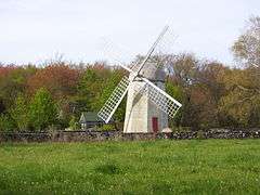

 Friends Meeting House with Jamestown Windmill in background
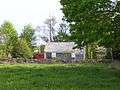 rear view of the Friends Meeting House (Quaker)
 View of Watson Farm down to the shore of Narragansett Bay