Williams, Oregon
| Williams, Oregon | |
|---|---|
|
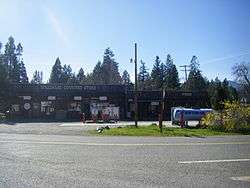
Williams Country Store | |
| Country | United States |
| State | Oregon |
| County | Josephine |
| Settled | 1881 |
| Area | |
| • Total | 77.8 sq mi (202 km2) |
| Elevation | 1,380 ft (420 m) |
| Time zone | Pacific (UTC-8) |
| • Summer (DST) | Pacific (UTC-7) |
| ZIP code | 97544 |
| Area code(s) | 541 |
Williams is an unincorporated community in Josephine County, Oregon, United States.
There were three different post offices in the area named for their proximity to Williams Creek: Williams, Williamsburg and Williams Creek (in Jackson County).[1] Williams Creek, which flows into the Applegate River, was named for Captain Robert Williams, who fought with Rogue River Indians along the creek during the Rogue River Wars of 1855-6.[1] Williams post office was established in 1881 and is about six miles upstream from Provolt on Williams Creek, and two miles west of the Jackson-Josephine county line.[1] The community is served by the Three Rivers School District; Williams Elementary School is located in the community.
According to the Associated Press, as of 2011, Williams' ZIP code had the highest concentration of people registered to grow medical marijuana of any ZIP code in Oregon.[2]
Climate
This region experiences warm (but not hot) and dry summers, with no average monthly temperatures above 71.6 °F. According to the Köppen Climate Classification system, Williams has a warm-summer Mediterranean climate, abbreviated "Csb" on climate maps.[3]
| Climate data for Williams | |||||||||||||
|---|---|---|---|---|---|---|---|---|---|---|---|---|---|
| Month | Jan | Feb | Mar | Apr | May | Jun | Jul | Aug | Sep | Oct | Nov | Dec | Year |
| Record high °F (°C) | 60 (16) |
68 (20) |
74 (23) |
87 (31) |
92 (33) |
95 (35) |
102 (39) |
101 (38) |
98 (37) |
89 (32) |
68 (20) |
61 (16) |
102 (39) |
| Average high °F (°C) | 46.7 (8.2) |
51 (11) |
55.7 (13.2) |
62.9 (17.2) |
68.7 (20.4) |
77.3 (25.2) |
84.5 (29.2) |
83.3 (28.5) |
76.1 (24.5) |
66.2 (19) |
53.9 (12.2) |
47 (8) |
64.4 (18) |
| Average low °F (°C) | 31.2 (−0.4) |
30.6 (−0.8) |
33.1 (0.6) |
36 (2) |
40.9 (4.9) |
45 (7) |
48.6 (9.2) |
48.2 (9) |
43.5 (6.4) |
37.4 (3) |
32.8 (0.4) |
31.5 (−0.3) |
38.2 (3.4) |
| Record low °F (°C) | 15 (−9) |
4 (−16) |
19 (−7) |
22 (−6) |
26 (−3) |
5 (−15) |
35 (2) |
35 (2) |
29 (−2) |
22 (−6) |
10 (−12) |
14 (−10) |
4 (−16) |
| Average precipitation inches (mm) | 6.15 (156.2) |
3.99 (101.3) |
3.67 (93.2) |
1.92 (48.8) |
1.43 (36.3) |
0.64 (16.3) |
0.25 (6.4) |
0.38 (9.7) |
0.73 (18.5) |
2.25 (57.2) |
5.09 (129.3) |
6.63 (168.4) |
33.12 (841.2) |
| Average snowfall inches (cm) | 4.3 (10.9) |
2.2 (5.6) |
1.8 (4.6) |
0.2 (0.5) |
0 (0) |
0 (0) |
0 (0) |
0 (0) |
0 (0) |
0 (0) |
0.5 (1.3) |
2.5 (6.4) |
11.5 (29.2) |
| Average precipitation days | 14 | 11 | 13 | 10 | 8 | 4 | 1 | 2 | 4 | 7 | 12 | 14 | 100 |
| Source: [4] | |||||||||||||
See also
References
- 1 2 3 McArthur, Lewis A.; McArthur, Lewis L. (2003) [1928]. Oregon Geographic Names (7th ed.). Portland, Oregon: Oregon Historical Society Press. pp. 1041–1043. ISBN 978-0875952772.
- ↑ "1 in 5 in Southern Oregon town has medical pot permit". KGW. August 3, 2011. Retrieved August 6, 2011.
- ↑ Climate Summary for Williams, Oregon
- ↑ "WILLIAMS 1 NW, OR (359390)". Western Regional Climate Center. Retrieved November 26, 2015.
Coordinates: 42°13′08″N 123°16′22″W / 42.21889°N 123.27278°W
Municipalities and communities of Josephine County, Oregon, United States | ||
|---|---|---|
| Cities | 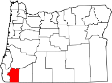 | |
| CDPs | ||
| Other unincorporated communities | ||
| Ghost towns | ||