Merlin, Oregon
| Merlin | |
|---|---|
| Unincorporated community | |
 Merlin  Merlin Location within the state of Oregon | |
| Coordinates: 42°31′04″N 123°25′13″W / 42.51778°N 123.42028°WCoordinates: 42°31′04″N 123°25′13″W / 42.51778°N 123.42028°W | |
| Country | United States |
| State | Oregon |
| County | Josephine |
| Elevation | 907 ft (276 m) |
| Time zone | Pacific (PST) (UTC-8) |
| • Summer (DST) | PDT (UTC-7) |
| ZIP code | 97532 |
| Area code(s) | 458 and 541 |
Merlin is an unincorporated community in Josephine County, Oregon, United States. The area is known for sport fishing and whitewater rafting on the Rogue River Merlin's ZIP code is 97532.
A new railroad station in this location in 1883 was called "Jump Off Joe" for a local stream. The station was renamed Merlin in October 1886. The name came from a railroad civil engineer who named it for the Merlins he saw in the area. "McAllister" post office was established about a mile north of Merlin in 1885, then moved to the vicinity of the railroad station and renamed Merlin in 1891.[1]
Geography
Merlin is located about 10 km (6.2 mi) northwest of Grants Pass.
Merlin lies at an elevation of about 277 m (909 ft) above MSL.
References
- ↑ McArthur, Lewis A.; McArthur, Lewis L. (2003) [1928]. Oregon Geographic Names (7th ed.). Portland, Oregon: Oregon Historical Society Press. p. 637. ISBN 978-0875952772.
External links
Municipalities and communities of Josephine County, Oregon, United States | ||
|---|---|---|
| Cities | 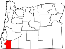 | |
| CDPs | ||
| Other unincorporated communities | ||
| Ghost towns | ||
This article is issued from Wikipedia - version of the 8/6/2016. The text is available under the Creative Commons Attribution/Share Alike but additional terms may apply for the media files.