Wild Rose, Wisconsin
| Wild Rose, Wisconsin | |
|---|---|
| Village | |
 | |
 Location of Wild Rose, Wisconsin | |
| Coordinates: 44°10′37″N 89°14′46″W / 44.17694°N 89.24611°WCoordinates: 44°10′37″N 89°14′46″W / 44.17694°N 89.24611°W | |
| Country | United States |
| State | Wisconsin |
| County | Waushara |
| Area[1] | |
| • Total | 1.55 sq mi (4.01 km2) |
| • Land | 1.53 sq mi (3.96 km2) |
| • Water | 0.02 sq mi (0.05 km2) |
| Elevation[2] | 951 ft (290 m) |
| Population (2010)[3] | |
| • Total | 725 |
| • Estimate (2012[4]) | 715 |
| • Density | 473.9/sq mi (183.0/km2) |
| Time zone | Central (CST) (UTC-6) |
| • Summer (DST) | CDT (UTC-5) |
| Area code(s) | 920 |
| FIPS code | 55-87075[5] |
| GNIS feature ID | 1576731[2] |
Wild Rose is a village in Waushara County, Wisconsin, United States. The population was 725 at the 2010 census.
History
A post office called Wild Rose has been in operation since 1873.[6] The village was named from wild rose bushes near the original town site.[7]
Geography
Wild Rose is located at 44°10′37″N 89°14′46″W / 44.17694°N 89.24611°W (44.177054, -89.246242).[8]
According to the United States Census Bureau, the village has a total area of 1.55 square miles (4.01 km2), of which, 1.53 square miles (3.96 km2) of it is land and 0.02 square miles (0.05 km2) is water.[1]
Demographics
| Historical population | |||
|---|---|---|---|
| Census | Pop. | %± | |
| 1880 | 25 | — | |
| 1910 | 551 | — | |
| 1920 | 576 | 4.5% | |
| 1930 | 512 | −11.1% | |
| 1940 | 559 | 9.2% | |
| 1950 | 582 | 4.1% | |
| 1960 | 594 | 2.1% | |
| 1970 | 585 | −1.5% | |
| 1980 | 741 | 26.7% | |
| 1990 | 676 | −8.8% | |
| 2000 | 765 | 13.2% | |
| 2010 | 725 | −5.2% | |
| Est. 2015 | 699 | [9] | −3.6% |
2010 census
As of the census[3] of 2010, there were 725 people, 316 households, and 174 families residing in the village. The population density was 473.9 inhabitants per square mile (183.0/km2). There were 377 housing units at an average density of 246.4 per square mile (95.1/km2). The racial makeup of the village was 95.9% White, 0.7% Native American, 0.6% Asian, 1.8% from other races, and 1.1% from two or more races. Hispanic or Latino of any race were 4.8% of the population.
There were 316 households of which 24.1% had children under the age of 18 living with them, 40.5% were married couples living together, 11.4% had a female householder with no husband present, 3.2% had a male householder with no wife present, and 44.9% were non-families. 42.4% of all households were made up of individuals and 24.6% had someone living alone who was 65 years of age or older. The average household size was 2.05 and the average family size was 2.78.
The median age in the village was 49.4 years. 19.2% of residents were under the age of 18; 3.8% were between the ages of 18 and 24; 19.4% were from 25 to 44; 25.1% were from 45 to 64; and 32.4% were 65 years of age or older. The gender makeup of the village was 45.0% male and 55.0% female.
2000 census
As of the census[5] of 2000, there were 765 people, 312 households, and 186 families residing in the village. The population density was 580.1 people per square mile (223.8/km²). There were 339 housing units at an average density of 257.0 per square mile (99.2/km²). The racial makeup of the village was 97.25% White, 0.78% African American, 0.13% Native American, 0.26% Asian, 0.92% from other races, and 0.65% from two or more races. Hispanic or Latino of any race were 2.22% of the population.
There were 312 households out of which 29.5% had children under the age of 18 living with them, 43.9% were married couples living together, 11.2% had a female householder with no husband present, and 40.1% were non-families. 36.9% of all households were made up of individuals and 19.6% had someone living alone who was 65 years of age or older. The average household size was 2.26 and the average family size was 2.97.
In the village the population was spread out with 23.5% under the age of 18, 5.8% from 18 to 24, 22.7% from 25 to 44, 21.3% from 45 to 64, and 26.7% who were 65 years of age or older. The median age was 43 years. For every 100 females there were 83.5 males. For every 100 females age 18 and over, there were 76.7 males.
The median income for a household in the village was $30,655, and the median income for a family was $37,361. Males had a median income of $32,188 versus $20,438 for females. The per capita income for the village was $18,887. About 4.2% of families and 6.6% of the population were below the poverty line, including 4.1% of those under age 18 and 12.8% of those age 65 or over.
Notable people
- Boyd A. Clark, Wisconsin State Assemblyman and jurist, was born in Wild Rose.[11]
Images
 Downtown Wild Rose
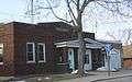 Village hall
References
- 1 2 "US Gazetteer files 2010". United States Census Bureau. Retrieved 2012-11-18.
- 1 2 "US Board on Geographic Names". United States Geological Survey. 2007-10-25. Retrieved 2008-01-31.
- 1 2 "American FactFinder". United States Census Bureau. Retrieved 2012-11-18.
- ↑ "Population Estimates". United States Census Bureau. Retrieved 2013-06-24.
- 1 2 "American FactFinder". United States Census Bureau. Retrieved 2008-01-31.
- ↑ "Waushara County". Jim Forte Postal History. Retrieved 1 April 2015.
- ↑ Chicago and North Western Railway Company (1908). A History of the Origin of the Place Names Connected with the Chicago & North Western and Chicago, St. Paul, Minneapolis & Omaha Railways. p. 139.
- ↑ "US Gazetteer files: 2010, 2000, and 1990". United States Census Bureau. 2011-02-12. Retrieved 2011-04-23.
- ↑ "Annual Estimates of the Resident Population for Incorporated Places: April 1, 2010 to July 1, 2015". Retrieved July 2, 2016.
- ↑ "Census of Population and Housing". Census.gov. Retrieved June 4, 2015.
- ↑ 'Wisconsin Blue Book 1948,' Biographical Sketch of Boyd A. Clark, p. 50.
External links
Municipalities and communities of Waushara County, Wisconsin, United States | ||
|---|---|---|
| Cities | 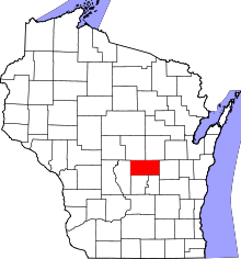 | |
| Villages | ||
| Towns | ||
| CDPs | ||
| Unincorporated communities | ||
| Ghost town | ||
| Footnotes | ‡This populated place also has portions in an adjacent county or counties | |