Weybridge, Vermont
| Weybridge, Vermont | |
|---|---|
| Town | |
|
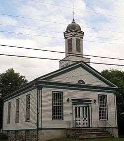
The Weybridge Town Hall on Quaker Village Road | |
| Motto: The Town of Peace and Tranquility | |
 Weybridge, Vermont | |
 Weybridge, Vermont Location in the United States | |
| Coordinates: 44°3′7″N 73°13′5″W / 44.05194°N 73.21806°WCoordinates: 44°3′7″N 73°13′5″W / 44.05194°N 73.21806°W | |
| Country | United States |
| State | Vermont |
| County | Addison |
| Area | |
| • Total | 17.6 sq mi (45.6 km2) |
| • Land | 17.1 sq mi (44.4 km2) |
| • Water | 0.5 sq mi (1.2 km2) |
| Elevation | 121 ft (37 m) |
| Population (2010) | |
| • Total | 833 |
| • Density | 49/sq mi (18.8/km2) |
| Time zone | Eastern (EST) (UTC-5) |
| • Summer (DST) | EDT (UTC-4) |
| ZIP code | 05753 |
| Area code | 802 |
| FIPS code | 50-83275[1] |
| GNIS feature ID | 1462258[2] |
| Website |
www |
Weybridge is a town in Addison County, Vermont, United States. The population was 833 at the 2010 census.[3]
Geography
Weybridge is located in central Addison County in the Champlain Valley. It is bordered by the town of Middlebury to the southeast, Cornwall to the south, Bridport to the southwest, Addison to the west, and New Haven to the north. Otter Creek forms much of the northern and eastern border of the town.
According to the United States Census Bureau, the town has a total area of 17.6 square miles (45.6 km2), of which 17.1 square miles (44.4 km2) is land and 0.46 square miles (1.2 km2), or 2.65%, is water.[4]
Demographics
| Historical population | |||
|---|---|---|---|
| Census | Pop. | %± | |
| 1790 | 175 | — | |
| 1800 | 502 | 186.9% | |
| 1810 | 750 | 49.4% | |
| 1820 | 714 | −4.8% | |
| 1830 | 850 | 19.0% | |
| 1840 | 797 | −6.2% | |
| 1850 | 804 | 0.9% | |
| 1860 | 667 | −17.0% | |
| 1870 | 627 | −6.0% | |
| 1880 | 608 | −3.0% | |
| 1890 | 543 | −10.7% | |
| 1900 | 518 | −4.6% | |
| 1910 | 494 | −4.6% | |
| 1920 | 438 | −11.3% | |
| 1930 | 418 | −4.6% | |
| 1940 | 385 | −7.9% | |
| 1950 | 402 | 4.4% | |
| 1960 | 430 | 7.0% | |
| 1970 | 618 | 43.7% | |
| 1980 | 667 | 7.9% | |
| 1990 | 749 | 12.3% | |
| 2000 | 824 | 10.0% | |
| 2010 | 833 | 1.1% | |
| Est. 2014 | 828 | [5] | −0.6% |
| U.S. Decennial Census[6] | |||
As of the census[1] of 2000, there were 824 people, 322 households, and 230 families residing in the town. The population density was 48.5 people per square mile (18.7/km2). There were 334 housing units at an average density of 19.6 per square mile (7.6/km2). The racial makeup of the town was 98.42% White, 0.61% African American, 0.49% Asian, and 0.49% from two or more races. Hispanic or Latino of any race were 1.58% of the population.
There were 322 households out of which 32.9% had children under the age of 18 living with them, 64.3% were married couples living together, 4.3% had a female householder with no husband present, and 28.3% were non-families. 20.8% of all households were made up of individuals and 10.9% had someone living alone who was 65 years of age or older. The average household size was 2.56 and the average family size was 2.99.
In the town the age distribution of the population shows 25.0% under the age of 18, 4.5% from 18 to 24, 26.9% from 25 to 44, 28.6% from 45 to 64, and 14.9% who were 65 years of age or older. The median age was 41 years. For every 100 females there were 94.8 males. For every 100 females age 18 and over, there were 94.3 males.
The median income for a household in the town was $51,833, and the median income for a family was $56,591. Males had a median income of $35,833 versus $30,089 for females. The per capita income for the town was $24,735. About 2.2% of families and 3.6% of the population were below the poverty line, including 3.4% of those under age 18 and 7.4% of those age 65 or over.
Notable people
- Claire D. Ayer, state senator
- Darius Clark, physician and politician
- Sidney Lawrence, US congressman
- George T. Tobin, American illustrator, native of Weybridge
- Silas Wright, US senator
References
- 1 2 "American FactFinder". United States Census Bureau. Retrieved 2008-01-31.
- ↑ "US Board on Geographic Names". United States Geological Survey. 2007-10-25. Retrieved 2008-01-31.
- ↑ 2010 U.S. Census data for Weybridge, Vermont
- ↑ "Geographic Identifiers: 2010 Demographic Profile Data (G001): Weybridge town, Addison County, Vermont". U.S. Census Bureau, American Factfinder. Retrieved August 30, 2013.
- ↑ "Annual Estimates of the Resident Population for Incorporated Places: April 1, 2010 to July 1, 2014". Retrieved June 4, 2015.
- ↑ "U.S. Decennial Census". United States Census Bureau. Retrieved May 16, 2015.
External links
Municipalities and communities of Addison County, Vermont, United States | ||
|---|---|---|
| City | 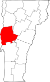 | |
| Towns | ||
| CDPs | ||
| Other communities | ||