Westfield Southland
|
The shopping centre alongside Nepean Highway | |
| Location | Cheltenham, Victoria, Australia |
|---|---|
| Opening date | September 1968 |
| Owner |
Jointly Owned:
|
| No. of stores and services | ~400[2] |
| Total retail floor area | ~129,180m²[2] |
| No. of floors |
|
| Parking | 5,980[2] |
| Website | www.westfield.com.au/southland |
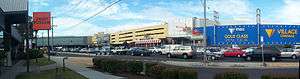
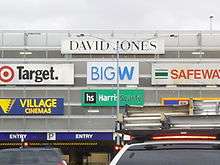
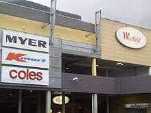
Westfield Southland shopping centre is a super regional retail complex located in the suburb of Cheltenham, approximately 16 kilometres from the Melbourne CBD in Victoria, Australia. Southland has a floor area of 129,180m², making it one of the biggest shopping centres in Australia by size.[2] There are approximately 400 retailers in Southland, including Myer, David Jones and Harris Scarfe. According to the Melbourne 2030 Metropolitan Strategy, Southland is recognised as one of 26 Principal Activity Centres.[3] The centre is also one of the most profitable shopping centres in Australia, with an annual turnover of $806.5-million recorded in 2015.[2]
History
Southland shopping centre was designed by Melbourne architects Tomkins, Shaw & Evans,[4] who had previously designed Westfield Miranda (then Miranda Fair) in 1964. At the time of its opening in September 1968, Southland was one of Melbourne's premier shopping centres. It was a relatively small shopping centre with only a few stores such as a Myer department store, Safeway supermarket, and a special roof garden. Architects Tomkins, Shaw & Evans received the Victoria Award in 1969 for their design of Southland, beating the National Gallery of Victoria for the award. This was during a period when shopping centres were recognised "for the quality of their design or amenity".[4] Prior to the mid–1980s Southland was owned by the Myer Emporium, and the centre would not rival the nearby Chadstone Shopping Centre in size, until the Westfield Group took over management.[5]
During Southland's history, many renovations and facelifts have shaped the centre, such as the first expansion in 1987 and the development of a Village Cinemas complex and food court in 1990. The rooftop garden was removed upon first redevelopment and was replaced with a third level of stores.[6]
1990s redevelopment

Prior to the extension, the 70,000 m² Southland shopping centre had very limited development options.[7] In June 1991, Westfield developers began discussions with the City of Moorabbin about the rezoning of the 60,000 m² Cheltenham market area in order for them to construct a multimillion-dollar extension of Southland as part of a major redevelopment. The original plan was to have replaced the market with a 10-storey office tower and a two-level shopping centre, with a retail bridge connecting the new centre with the existing Westfield Centre over the eight-lane Nepean Highway. The new centre would feature a discount supermarket and a regular supermarket as well as new specialty stores. All up, the whole centre would comprise up to 360 stores. In June 1993, planning approval was given by the Minister for Planning Rob Maclellan.[8]

In December 1996, plans were changed in favour of better car park arrangements as well as easier access to the centre. The centre would soon feature more than 400 stores across three levels.[6]
In November 1997, demolition commenced at the Cheltenham market site. In March 1998, the first concrete was poured by the Premier of Victoria Jeff Kennett.[6] The two sites were to be linked by a bridge with shops on it. The former cinemas and food court were demolished, and the wide, multi-level retail-pedestrian-vehicle bridge (largest of its kind in the Southern Hemisphere[9]) was added. During this time, the Myer anchor moved from the original site to the newer site. Construction was not just limited to the new site with the original site being upgraded to include a new larger cinema complex, in the youth-oriented mall called The Street.
The redevelopment was opened in stages, with The Street opening in April 1999. The main part of the redevelopment, the additional site and bridge were opened on October 28, 1999.[10] The $300 million redevelopment was completed on May 5, 2000, with the opening of the David Jones Department store.[7][11]
Subsequently, another $13 million was used for additional work, which included construction of shaded car park areas, two new car park ramps as well as a large glass window attached to the second level of the retail bridge, which has views 16 kilometres in the distance of the Melbourne CBD.[7][12]
Stores
Westfield Southland features up to 400 stores including 3 department stores, 3 discount department stores, 3 supermarkets, 3 electrical (computers, television etc.) retailers and a 16 screen Village Cinemas Multiplex (movie theatre).[13]
Major stores
- Myer department store
- David Jones department store
- Coles supermarket (18 aisles, 5,100m²)(New latest concept store)
- Kmart discount department store (7,568m²) (refurbished in 2012)
- Target discount department store (8,940m²)
- Woolworths supermarket (18 aisles, 4,246m²)
- Big W discount department store (8,179m²)
- Aldi supermarket (850m²)
- Harris Scarfe department store
- Village Cinemas 16 screen cinema multiplex with Gold Class, Cinema Europa and Vmax cinemas
Minor stores
- Best & Less discount apparel store
- Apple Store electrical store
- JB Hi-Fi electrical store
- The Reject Shop discount variety store
- Rebel Sport sporting goods store
- Lincraft haberdashery store.
Former stores
- BI-LO supermarket
- Franklins supermarket
- Harvey Norman electrical store
- Dick Smith Electronics powerhouse electrical store
- Wild Bills saloon bar & night club
Southland in film and television
A large number of scenes for the Seven Network comedy Kath & Kim were filmed at Southland. In the programme the centre is designated as Fountain Gate, where some of the shopping scenes are also filmed. The centre is also featured in multiple episodes of the ABC2 television drama-comedy series Please Like Me.[14]
Transport
Buses
Westfield Southland has a major bus interchange located on the corner of Karen Street and Nepean Highway. This bus interchange has 11 ptv routes (600/922/923, 631, 708, 767, 811/812, 821, 822, 823, 825, 828).
Trains
Westfield Southland is a fifteen-minute walk or a short bus ride from Cheltenham railway station.
In 2015, the Victorian Government committed to building a railway station at Southland to serve the busy shopping centre. The railway station will cost approximately $13 million and it will have two platforms. The station will be a premium station located on the Frankston line, adjacent to Southland. Construction on the station is to commence in 2016 and be completed by 2017.[15][16] When Southland opened in 1968, discussions were raised on whether a railway station would be built on the Frankston line, adjacent to land then-occupied by the St John of God home for boys. Despite this, plans were not submitted.[17][18] The proposal arose again in 1990, in conjunction with the redevelopment of Southland, however proposals fell through.
See also
- Cheltenham, Victoria
- List of shopping centres in Australia
- Proposed Melbourne rail extensions
- Southland railway station
- Scentre Group
References
- ↑ Condon, Turi (20 June 2014). "Westfield restructure a success: Lowy". The Australian Business Review. Retrieved 14 October 2014.
- 1 2 3 4 5 Westfield Southland Portfolio. Scentre Group. Retrieved 27 January 2016
- ↑ Melbourne2030online
- 1 2 Walker, Paul. 2015. Reinventing Southland: The Shopping Mall and Public Program. University of Melbourne. Retrieved 27 January 2016
- ↑ Upton, David. (6 August 1987). "Property Trust duo adds $293m to issues queue". The Sydney Morning Herald. Retrieved 27 January 2016
- 1 2 3 Kingston Historical Site - "Westfield Spans Nepean Highway". Retrieved 27 January 2016
- 1 2 3 Westfield Shoppingtown Southland Development Pdf
- ↑ Graham, Tim and Buchanan, Kathleen. (2 June 1993). "Go-ahead for $500m shops plan". The Age. Retrieved 6 June 2015
- ↑ City of Kingston - "Retail Infrastructure"
- ↑ Westfield Southland opens new Myer retail bridge Westfield Corporate. 28 October 1999
- ↑ David Jones store opening completes redevelopment of Westfield Shoppingtown Southland Westfield Corporate. 5 May 2000
- ↑ Rafferty, Michelle. (16 September 2002). "City views on the - menu at Southland". Sandringham Brighton Advertiser. Retrieved 6 June 2015
- ↑ Cheltenham Activity Centre Structure Plan - "Background Report". Retrieved 22 March 2010
- ↑ "Sausage Sizzle". Please Like Me. Season 2. Episode 5. September 9, 2014. ABC2.
- ↑ Sommerville, Troels. (21 December 2015). "Commuters in for more delays as Southland train station works begin". Moorabbin Glen Eira Leader. Retrieved 28 December 2015
- ↑ Sommerville, Troels (11 March 2015). "Southland train station plans released ahead of consultation sessions". Herald Sun. Retrieved 12 March 2015.
- ↑ Gough, Deborah. (23 April 2014). "No public toilets for new $21m Southland train station". The Age. Retrieved 27 January 2016
- ↑ Marshall, Norman. "Methodist Children’s Homes at Cheltenham : A Time for Change". Kingston Historical Website. Retrieved 27 January 2016
External links
- Southland Shopping Centre image gallery
- Westfield Southland homepage
- Department of Transport - New station at Southland
Coordinates: 37°57′29″S 145°03′00″E / 37.958°S 145.05°E