Stockland The Pines
|
Main Entrance | |
| Location | Doncaster East, Victoria, Australia |
|---|---|
| Opening date | 27 October 1986[1] |
| Management | Stockland Limited |
| Owner | Stockland Limited |
| No. of stores and services | 101[1] |
| No. of anchor tenants | 4 |
| Total retail floor area | 25,260 m2 (271,900 sq ft)[1] |
| No. of floors | 1 |
| Parking | 1,400 (170 undercover) |
| Website | www.stockland.com.au/thepines |
Stockland The Pines is a sub regional shopping centre located in the north-eastern suburb of Doncaster East in the city of Melbourne, Australia. The centre is approximately 19 km east of the Melbourne CBD and is situated on the corner of Blackburn and Reynolds Roads. It was opened on 27 October 1986 by the state opposition leader of the time Jeff Kennett. Amenities at Stockland The Pines include a library, community centre, medical centre, several banks, over 100 speciality stores and undercover parking.Opening on Thursday 24th of November 2016 is Kmart.
Expansion
In 2000 the shopping centre which consisted of a Target, Safeway and 45 specialty stores with a GLA of 15,000 sqm underwent a minor cosmetic refurbishment. In 2004 the Westfield Group, who were the owner and manager of the centre at the time commenced a multimillion-dollar expansion of the centre to include Coles, Aldi, 55 new speciality stores and additional car parking at the northern end of the property.[2] In 2007 a multi-purpose community facility known as The Pines Learning and Activity Centre was opened at the back of the centre.[3]
Opinions are mixed in relation to the expansion, with some enjoying the wider range of shops available, while others mourn the smaller, more intimate nature of Stockland The Pines before its redevelopment.
Gallery
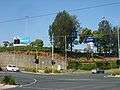 Stockland The Pines from the Reynolds Rd/Blackburn Rd intersection.
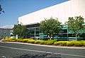 The Pines library.
 Woolworths and surrounding stores.
 Internal mall.
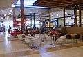 Food court.
 The main entrance to the shopping centre near the bus terminus.
 Aerial view from west.
References
| Wikimedia Commons has media related to Stockland The Pines. |
- 1 2 3 "Stockland The Pines - Casual Mall Leasing Information" (PDF). December 2012. Stockland Limited. Retrieved 9 November 2013.
- ↑ "Stockland and Westfield agree to asset swap." (PDF). 09/08/2004. Stockland Corporation Limited. Retrieved 2013-11-11.
- ↑ "The Pines Activity Centre - Structure Review Plan" (PDF). Manningham City Council. Retrieved 2013-11-11.
Coordinates: 37°45′43″S 145°10′7″E / 37.76194°S 145.16861°E