Western Kangaroo Island Commonwealth Marine Reserve
| Western Kangaroo Island Commonwealth Marine Reserve Australia | |
|---|---|
 Western Kangaroo Island Commonwealth Marine Reserve | |
| Nearest town or city | Kingscote |
| Coordinates | 35°45′52.56″S 136°17′3.84″E / 35.7646000°S 136.2844000°ECoordinates: 35°45′52.56″S 136°17′3.84″E / 35.7646000°S 136.2844000°E |
| Established | 8 December 2012[1] |
| Area | 2,335.31 km2 (901.7 sq mi)[2] |
| Managing authorities | Department of the Environment |
| Website | Western Kangaroo Island Commonwealth Marine Reserve |
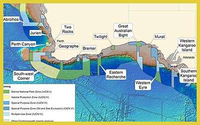
Western Kangaroo Island Commonwealth Marine Reserve is a marine protected area located south of South Australia in waters within the Australian Exclusive economic zone to the south-west of Kangaroo Island and ranging in depth from 15 metres (49 ft) to 165 metres (541 ft). It was gazetted in November 2012. It is part of a group of Commonwealth marine reserves managed by the Department of the Environment known as the South-west Commonwealth Marine Reserves Network. It is intimately associated with the Western Kangaroo Island Marine Park managed by the Government of South Australia which it both bounds on its north-west side and fully encloses the portion of the state marine park surrounding Lipson Reef near its eastern extent. The reserve includes ecosystems representative of the bioregion known as the "Spencer Gulf Shelf Province", two "key ecological features" consisting of firstly of a feature known as the "Kangaroo Island Pool" and the associated "Eyre Peninsula upwelling" both notable for their "high productivity, breeding and feeding aggregations" and secondly of a feature described as "Ancient coastline" within a depth range of 90–120 metres (300–390 ft) and as being of "high productivity", a calving area for southern right whale and feeding areas for the following species - Australian sea lion, blue whale, Caspian tern, great white shark, short-tailed shearwater and sperm whale. The reserve consists of two zones - a marine national park zone (IUCN Category II) with an area of 120 square kilometres (46 sq mi) and a special purpose zone (IUCN Category VI) with an area of 2,215 square kilometres (855 sq mi).[2][1][3][4][5]
See also
References
- 1 2 "Environment Protection and Biodiversity Conservation (Commonwealth Marine Reserves) Proclamation 2012 - F2012L02188". Commonwealth of Australia, Comlaw. Retrieved 19 March 2015.
- 1 2 "Collaborative Australian Protected Area Database (CAPAD) - consolidated data set for all marine protected areas in Australian State and Commonwealth waters (refer "DETAIL' tab)". Department of the Environment. Retrieved 12 July 2015.
- ↑ "Western Kangaroo Island Marine Park Management Plan 2012" (PDF). Department of Environment Water and Natural Resources. 2012. p. 28. Retrieved 15 May 2014.
- ↑ "Western Kangaroo Island Commonwealth Marine Reserve". Department of the Environment (DoE). Retrieved 12 July 2015.
- ↑ "Western Kangaroo Island Commonwealth Marine Reserve - Maps". Department of the Environment (DoE). Retrieved 12 July 2015.