List of World Heritage Sites in Oceania
A World Heritage Site is a location that is listed by UNESCO as having outstanding cultural or natural value to the common heritage of humanity.[1] The World Heritage Committee has designated 32 World Heritage Sites in Oceania. These are in 11 countries, with the majority of sites being located in Australia. The first three inscriptions from the region, the Great Barrier Reef, Kakadu National Park and the Willandra Lakes, were in 1981—three years after the list's creation.[2] The region contains the world's three largest sites: Phoenix Islands Protected Area, Papahānaumokuākea and the Great Barrier Reef.[3][4] In addition, the Tasmanian Wilderness is one of only two sites in the world that meet seven out of the ten criteria for World Heritage listing (Mount Tai in China being the other).
Each year, the World Heritage Committee may inscribe new sites on the list, or delist sites that no longer meet the criteria. Selection is based on ten criteria: six for cultural heritage (i–vi) and four for natural heritage (vii–x). Some sites, designated "mixed sites", represent both cultural and natural heritage. In Oceania there are 7 cultural, 19 natural and 5 mixed sites.[5] UNESCO may also specify that a site is in danger, stating "conditions which threaten the very characteristics for which a property was inscribed on the World Heritage List."[6] In 2013, the Committee added East Rennell to the List of World Heritage in Danger because of the threat of logging activities to the site's outstanding universal value.[7]
Legend
The list below includes all sites located geographically within Oceania, and is constructed without reference to UNESCO's statistical divisions.[8] The list comprises a number of sites for which the state party is outside the region, but the site itself is located in Oceania; this includes sites belonging to Chile (Rapa Nui National Park), France (Lagoons of New Caledonia), the United Kingdom (Henderson Island), and the United States (Hawaii Volcanoes National Park, Papahānaumokuākea). The table is sortable by column by clicking on the ![]() icon at the top of the appropriate column; alphanumerically for the Site, Area, and Year columns; by state party followed by the region for the Location column; and by criteria type followed by the country for the Criteria column.
icon at the top of the appropriate column; alphanumerically for the Site, Area, and Year columns; by state party followed by the region for the Location column; and by criteria type followed by the country for the Criteria column.
- Site – named after the World Heritage Committee's official designation.[5]
- Location – sorted by country, followed by the region at the regional or provincial level. In the case of multinational or multi-regional sites, the names are sorted alphabetically.
- Criteria – as defined by the World Heritage Committee.[1]
- Area – in hectares and acres, excluding any buffer zones. A value of zero implies that no data has been published by UNESCO.
- Year – during which the site was inscribed to the World Heritage List.
- Description – brief information about the site. None of the sites in this list have been classified as endangered.[9]
Sites
| Site | Image | Location | Criteria | Area ha (acre) | Year | Description |
|---|---|---|---|---|---|---|
| Australian Fossil Mammal Sites (Riversleigh / Naracoorte) | 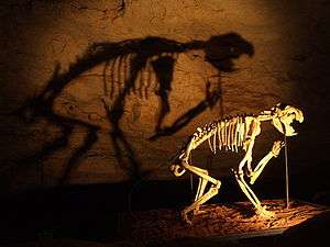 | Queensland and South Australia, 19°05′00″S 138°43′00″E / 19.083333°S 138.716667°E[note 1] | Natural: (viii), (ix) | 10,300 (25,000) | 1992 | Riversleigh and Naracoorte were inscribed for their extensive fossil records, and are listed among the ten richest deposits in the world. Both are illustrative of separate, key stages in the evolution of mammals on the Australian continent. Riversleigh has provided some of the earliest mammalian records from the middle Cenozoic. The deposit at Naracoorte, Australia's largest, spans the much-more-recent Pleistocene epoch and the first migrations of humans to Australia. It contains some of the best-preserved examples of ice-age megafauna.[10] |
| Australian Convict Sites | 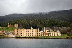 | New South Wales, Norfolk Island, Tasmania and Western Australia, 33°22′42″S 150°59′40″E / 33.378333°S 150.994444°E[note 2] | Cultural: (iv), (vi) | 1,503 (3,710) | 2010 | There are over 3000 convict sites remaining in Australia,[11] which were established by the British Fleets in the early colonial period of Australia's history. Eleven of these sites were selected as the most outstanding examples in the country.[note 3][12] |
| Bikini Atoll Nuclear Test Site |  | Ralik Chain, 11°36′00″N 165°22′50″E / 11.6°N 165.380556°E | Cultural: (iv), (vi) | 0.97 (2.4) | 2010 | A total of 67 nuclear weapons tests were conducted here by the United States between 1946 and 1958, including the detonation of the first hydrogen bomb in 1952. The tests had significant consequences on the health of the surrounding environment and its inhabitants. The fallout from the Castle Bravo explosion in 1954 led to the most significant radiological contamination in U.S. history. The site contains many visible remains of the effects of nuclear testing.[13] |
| Chief Roi Mata's Domain | 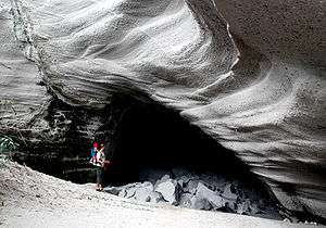 | Shefa, 17°37′41″S 168°10′40″E / 17.628069°S 168.177719°E | Cultural: (iii), (v), (vi) | 886 (2,190) | 2008 | Consists of three sites on the islands of Efate, Lelepa and Artok associated with Roy Mata, a 13th-century paramount chief whose social reforms have remained relevant to contemporary local society. It includes his residence in the abandoned settlement of Mangaas, the site of his death on Lelepa, and his burial site on the island of Artok.[14] |
| East Rennell |
 | Rennell and Bellona, 11°41′00″S 160°20′00″E / 11.683330°S 160.333330°E | Natural: (ix) | 37,000 (91,000) | 1998 | Rennell Island is the world's largest raised coral atoll. It is heavily forested and hosts high levels of endemism. The southern portion of the atoll surrounds its former lagoon, Te Nggano, which is now the largest lake in the Pacific Ocean.[15] |
| Fraser Island | 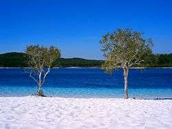 | Queensland, 25°13′00″S 153°08′00″E / 25.216667°S 153.133333°E | Natural: (vii), (viii), (ix) | 184,000 (450,000) | 1992 | Fraser Island is the world's largest sand island, composed of sand accumulated over approximately 750,000 years. It contains over 100 freshwater lakes, and dunes reaching up to 260 m (850 ft) above sea level. Due to naturally occurring mycorrhizal fungi present in the sand, it is the only place in the world where tall rainforest grows on sand.[16] |
| Gondwana Rainforests of Australia | 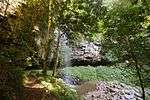 | Queensland and New South Wales, 28°15′S 150°03′E / 28.25°S 150.05°E | Natural: (viii), (ix), (x) | 370,000 (910,000) | 1986 | This site was inscribed for its significance for geology and conservation. It covers a large number of protected areas in what is the most extensive area of subtropical rainforest in the world. It has an extremely high conservation value, with more than 200 rare or threatened plant and animal species.[17] |
| Great Barrier Reef |
.jpg) | Queensland, 18°17′10″S 147°42′00″E / 18.286111°S 147.7°E | Natural: (vii), (viii), (ix), (x) | 34,870,000 (86,200,000) | 1981 | The world's largest coral reef system, composed of over 2,900 individual reefs. It hosts an outstanding level of marine biodiversity and is considered likely to be the richest area in the world in terms of animal diversity. It is home to approximately 400 types of coral, and forms a critical habitat for many endangered species.[18] |
| Greater Blue Mountains Area | 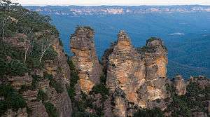 | New South Wales, 33°42′S 150°00′E / 33.7°S 150°E | Natural: (ix), (x) | 1,032,649 (2,551,730) | 2000 | An area of sandstone tablelands and gorges. Covered by eucalypt forest, the area was inscribed as a representation of Australia's biodiversity, with particular regard to the diversity of eucalypt species. It is composed of eight protected areas providing crucial habitats for many endangered species.[19] |
| Hawaii Volcanoes National Park | 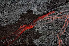 | Hawaiʻi, 19°24′03″N 155°07′25″W / 19.400833°N 155.123611°W | Natural: (viii) | 92,934 (229,640) | 1987 | Located on Hawaiʻi Island, it is home to two of the world's most active volcanoes: Kilauea and Mauna Loa. As constant volcanic activity is easily observed, the area has provided scientific insight into the processes of volcanism, including the birth of the Hawaiʻian Islands.[20] |
| Heard and McDonald Islands | 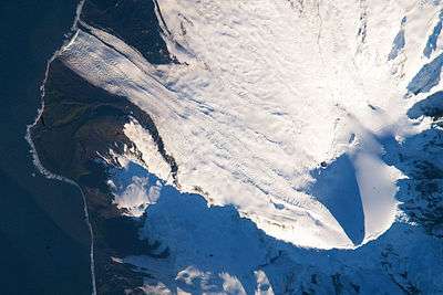 | Heard and McDonald Islands, 53°06′S 73°30′E / 53.1°S 73.5°E | Natural: (viii), (ix) | 37,200 (92,000) | 1997 | These two islands are the only two active volcanoes in the subantarctic, and were inscribed for their value to research in glaciology and geomorphic processes. Over three-quarters of Heard Island is covered by glaciers. Because of their remoteness, the ecosystem is undisturbed, with no history of significant human impact or any introduced species.[21] |
| Henderson Island | 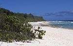 | Pitcairn Islands, 24°22′00″S 128°20′00″W / 24.366667°S 128.333333°W | Natural: (vii), (x) | 3,700 (9,100) | 1988 | One of the most remote islands in the world, Henderson is home to an ecosystem undisturbed by human activity and hosting multiple endemic species. It was inscribed as a tremendous value to natural science, providing the opportunity to study the dynamics of an isolated ecosystem.[22] |
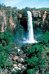
| Kakadu National Park | 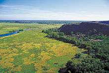 | Northern Territory, 12°50′00″S 132°50′00″E / 12.8333°S 132.8333°E | Mixed: (i), (vi), (vii), (ix), (x) | 1,979,766 (4,892,110) | 1981 | Kakadu's wetlands, covering over a third of the park, are considered internationally important.[23] Several archaeological sites provide evidence of the area's habitation for more than 40,000 years. The pictographs at Ubirr, Burrunggui and Nanguluwu are internationally recognised as outstanding examples of ancient rock art, dating from over 18,000 years ago.[24] |
| Kuk Early Agricultural Site | 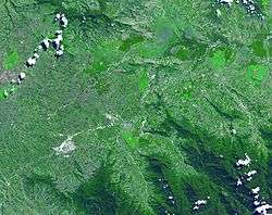 | Western Highlands, 5°47′01″S 144°19′54″E / 5.783711°S 144.331722°E | Cultural: (iii), (iv) | 116 (290) | 2008 | Archaeological surveys at Kuk Swamp have provided evidence of primitive irrigation and cultivation systems from about 9,000 years ago, making it one of the earliest sites for the development of agriculture in the world.[25] |
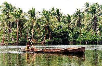
| Lagoons of New Caledonia: Reef Diversity and Associated Ecosystems | 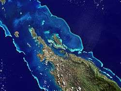 | New Caledonia, 20°24′43″S 164°33′59″E / 20.4119°S 164.5664°E | Natural: (vii), (ix), (x) | 1,574,300 (3,890,000) | 2008 | One of the three largest reef systems in the world, enclosing a lagoon area of 24,000 km2 (9,300 sq mi). The density of reef structures here is the most diverse in the world. It host a great diversity of species with a high level of endemism, and is an important habitat for endangered dugongs and sea turtles.[26] |
| Levuka Historical Port Town | 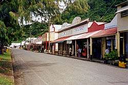 | Eastern Division, 17°41′00″S 178°50′04″E / 17.683378°S 178.834533°E | Cultural: (ii), (iv) | 70 (170) | 2013 |
The town of Levuka, on the eastern beachfront of Ovalau, was the first site of European settlement in Fiji, becoming the British colonial capital of Fiji in 1874. The numerous and well-preserved buildings of the era, make it an excellent example of a colonial port developed during the late 19th century in the South Pacific.[27] |
| Lord Howe Island Group | 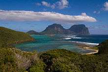 | New South Wales, 31°33′56″S 159°05′18″E / 31.565556°S 159.088333°E | Natural: (vii), (x) | 1,540 (3,800) | 1982 | This island is the eroded remains of a seven-million-year-old shield volcano, the product of eruptions that lasted for about a half-million years.[28] It is home to numerous endemic species, significant breeding colonies of seabirds, and the world's southernmost coral reef.[29] |
| Macquarie Island | 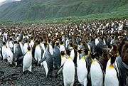 | Tasmania, 54°35′41″S 158°53′44″E / 54.594722°S 158.895556°E | Natural: (vii), (viii) | 540,000 (1,300,000) | 1997 | Lying atop a segment of the Macquarie Ridge, the island is the only place on earth where the mantle is exposed above sea level. It contains evidence of seafloor spreading. It was inscribed for its unique geological value.[30] |
| New Zealand Sub-Antarctic Islands | 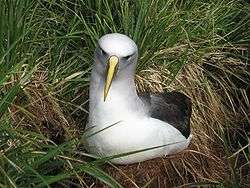 | Outlying Islands, 50°45′00″S 166°06′16″E / 50.75°S 166.104444°E[note 4] | Natural: (ix), (x) | 76,458 (188,930) | 1998 | Comprising the Antipodes Islands, Auckland Islands, Bounty Islands, Campbell Islands and The Snares. The islands are noted for the diversity and density of wildlife, with high levels of endemism. They are critical breeding ground for a range of species, and host huge breeding colonies of seabirds, penguins and sea lions.[31] |
| Ningaloo Coast | 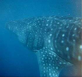 | Western Australia, 22°33′45″S 113°48′37″E / 22.562500°S 113.810278°E | Natural: (vii), (x) | 705,015 (1,742,130) | 2011 | Noted for its exceptional marine biodiversity, including over 700 fish species and an abundance of endangered sea turtles. It hosts the largest known seasonal aggregations of whale sharks and is part of the annual migration routes of dolphins, dugongs, manta rays and humpback whales.[32] |
| Papahānaumokuākea | 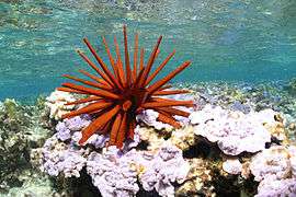 | Hawaii, 25°21′N 170°9′W / 25.350°N 170.150°W | Mixed: (iii), (vi) (viii), (ix), (x) | 36,207,499 (89,470,680) | 2010 | This chain of islands was formed as a result of hotspot volcanism. It supports almost 7,000 marine species, one quarter of which are endemic, and is critical to the survival of several endangered species. The islands are spiritually significant to many Native Hawaiians, being associated with the concept of kinship between man and nature. Two of the islands contain well-preserved heiau shrines.[33] |
| Phoenix Islands Protected Area | .JPG) | Phoenix Islands, 3°38′59″S 172°51′27″W / 3.649722°S 172.8575°W | Natural: (vii), (ix) | 40,825,000 (100,880,000) | 2010 | Encompassing the sparsely inhabited, inhospitable Phoenix Islands, this reserve protects one of the world's largest oceanic wildernesses. It covers a variety of marine habitats, and forms a major breeding ground on the migration routes of several marine and seabird species. It is considered to be of vital significance in evaluating the consequences of climate change on sea levels and the health of coral reefs.[34] |
| Purnululu National Park | 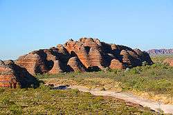 | Western Australia, 17°30′S 128°30′E / 17.5°S 128.5°E | Natural: (vii), (viii) | 239,723 (592,370) | 2003 | The Bungle Bungle Range is a Devonian plateau that has been heavily eroded into a dramatic landscape of conical sandstone towers. It is one of the largest network of sandstone karst formations in the world, parts of which are sacred to the indigenous Kija people.[35] |
| Rapa Nui National Park | 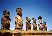 | Isla de Pascua, 27°07′00″S 109°22′00″W / 27.116667°S 109.366667°W | Cultural: (i), (iii), (v) | 7,130 (17,600) | 1995 | Covering almost half of Easter Island, this park showcases the unique cultural landscape produced by the isolated Rapanui civilisation. Its most recognisable features are the distinctive moai statues and ceremonial shrines (ahu). It was inscribed on the list as a "remarkable cultural phenomenon".[36] |
| Rock Islands Southern Lagoon | .jpg) | Koror, 7°14′49″N 134°21′09″E / 7.246925°N 134.3525°E | Mixed: (iii), (v), (vii), (ix), (x) | 100,200 (248,000) | 2012 | Rock Islands Southern Lagoon covers 100,200-hectare and numbers 445 uninhabited limestone islands of volcanic origin. Many of them display unique mushroom-like shapes in turquoise lagoons surrounded by coral reefs. The site features over 385 coral species and different types of habitat. The site harbours the highest concentration of marine lakes anywhere, isolated bodies of seawater separated from the ocean by land barriers.[37] |
| Royal Exhibition Building and Carlton Gardens | 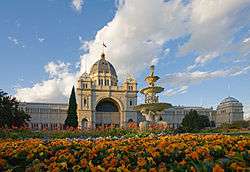 | Victoria, 37°48′22″S 144°58′13″E / 37.806111°S 144.970278°E | Cultural: (ii) | 26 (64) | 2004 | Made to host the world's fair in 1880, this is one of the world's last exhibition buildings from the 19th century, and combines several architectural styles. The adjacent gardens are an outstanding example of Victorian era landscape design.[38] |
| Shark Bay, Western Australia | 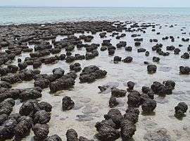 | Western Australia, 25°29′10″S 113°26′10″E / 25.486111°S 113.436111°E | Natural: (vii), (viii), (ix), (x) | 2,197,300 (5,430,000) | 1991 | With the largest and richest area of seagrass meadows in the world, this site is a critical habitat for endangered dugongs,[39] hosting about 12% of the world's population.[40] Hamelin Pool contains the world's most diverse and abundant colony of living stromatolites, providing some of the earliest records of life on earth.[41] |
| Sydney Opera House | 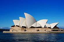 | New South Wales, 33°51′24″S 151°12′55″E / 33.856667°S 151.215278°E | Cultural: (i) | 5.80 (14.3) | 2007 | Opened in 1973, this performing arts complex is an iconic landmark of Sydney Harbour renowned for its innovative architecture. The design is an example of the expressionist style and has had a lasting influence on architecture.[42] |
| Tasmanian Wilderness |
 | Tasmania, 41°35′00″S 145°25′00″E / 41.583333°S 145.416667°E | Mixed: (iii), (iv), (vi), (vii), (viii), (ix), (x) | 1,407,513 (3,478,040) | 1982 | Covering almost 20% of Tasmania, this area constitutes one of the world's last stretches of temperate wilderness. It is dominated by the remote and inaccessible South West Wilderness area. Excavations in the area have uncovered evidence of aboriginal presence dating from at least 20,000 years ago.[43] |
| Te Wahipounamu – South West New Zealand | 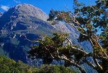 | South Island, 45°02′10″S 167°19′11″E / 45.036028°S 167.319611°E | Natural: (vii), (viii), (ix), (x) | 2,600,000 (6,400,000) | 1990[note 5] | A mountainous landscape of ridges and fjords shaped by thousands of years of glacial excavation. The area incorporates several national parks and is the most pristine wilderness in New Zealand. It hosts the best surviving illustration of ancient Gondwanan wildlife, much of which is rare and unique to the area.[44] |
| Tongariro National Park | 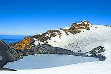 | Ruapehu, 39°17′27″S 175°33′44″E / 39.290833°S 175.562222°E | Mixed: (vi), (vii), (viii) | 79,596 (196,690) | 1990 | Inscribed for its outstanding geological and cultural significance. It contains a diverse range of volcanic features. Many of its summits are sacred to Māori, as their traditional belief system associates the mountains with their ancient ancestors.[45] |
| Uluṟu-Kata Tjuṯa National Park | 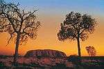 | Northern Territory, 25°20′S 131°00′E / 25.33°S 131°E | Mixed: (v), (vi), (vii), (viii) | 132,566 (327,580) | 1987 | Inscribed for its archaeological and cultural significance, being representative of Aboriginal spiritual connection to the land. The park's two massive sandstone formations, Uluṟu and Kata Tjuṯa, are spiritually significant to the Anangu people, and form part of the tjukurpa belief system. Cave paintings found at Uluru date back tens of thousands of years.[46] |
| Wet Tropics of Queensland | 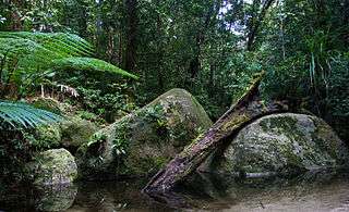 | Queensland, 15°39′S 144°58′E / 15.65°S 144.97°E | Natural: (vii), (viii), (ix), (x) | 894,420 (2,210,200) | 1988 | An area of tropical rainforest spread along the Great Dividing Range. The area hosts an exceptional level of biodiversity, with at least 85 endemic species and the highest concentration of primitive taxa in the world.[47] It is also an important area for unique and endangered marsupials.[48] |
| Willandra Lakes Region | 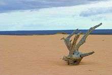 | New South Wales, 34°S 143°E / 34°S 143°E | Mixed: (iii), (viii) | 240,000 (590,000) | 1981 | A geological site containing fossilised remains of sand formations. It includes exceptional archaeological evidence of past human habitation from 45–60,000 years ago, including the world's oldest cremation site, the Lake Mungo remains.[49] |
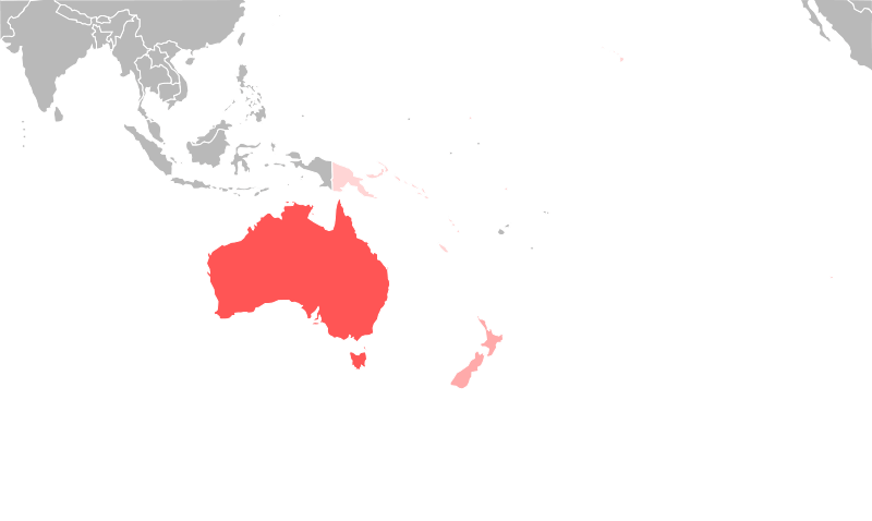
Map of sites
Notes
- ↑ Coordinates indicate the location of Riversleigh, one of two, widely spaced locations in the Australian Fossil Mammal Sites.
- ↑ Coordinates indicate the location of the Great North Road, one of several, widely scattered locations in the Australian Convict Sites.
- ↑ The sites are: Cockatoo Island Convict Site, Hyde Park Barracks, Old Government House and the Great North Road in New South Wales; Brickendon and Woolmers Estates, Cascades Female Factory, Coal Mines Historic Site, Darlington Probation Station and Port Arthur in Tasmania; Fremantle Prison in Western Australia and Kingston and Arthurs Vale Historic Area on Norfolk Island.
- ↑ Coordinates indicate the location of the Auckland Islands, one of five, widely spaced island groups in the New Zealand Sub-Antarctic Islands.
- ↑ When it was inscribed in 1990, Te Wahipounamu incorporated and superseded two previously-inscribed World Heritage Sites: Westland and Mount Cook National Park and Fiordland National Park. Both of the prior sites were inscribed in 1986.[44]
References
- 1 2 World Heritage Committee. "The Criteria for Selection". United Nations Educational, Scientific and Cultural Organization. Retrieved 2010-05-28.
- ↑ Young, Emma (29 August 2011). "World Heritage sites of Australia". Australian Geographic. Retrieved 13 February 2012.
- ↑ Staff writers (2010). "Marine Paradise Named Largest World Heritage Site". ABC News. ABC News Internet Ventures. Retrieved 2011-07-11.
- ↑ Great Barrier Reef Marine Park Authority. "Great Barrier Reef World Heritage Area". Government of Australia. Retrieved 2011-07-11.
- 1 2 World Heritage Committee. "World Heritage List Nominations". United Nations Educational, Scientific and Cultural Organization. Retrieved 2010-05-28.
- ↑ World Heritage Committee. "World Heritage in Danger". United Nations Educational, Scientific and Cultural Organization. Retrieved 2010-05-28.
- ↑ World Heritage Committee. "World Heritage Committee inscribes East Rennell on the List of World Heritage in Danger". United Nations Educational, Scientific and Cultural Organization. Retrieved 2013-08-13.
- ↑ "Number of World Heritage Properties by region". UNESCO. Retrieved 10 September 2011.
- ↑ World Heritage Committee. "The List in Danger". United Nations Educational, Scientific and Cultural Organization. Retrieved 2010-05-28.
- ↑ World Heritage Committee. "Australian Fossil Mammal Sites (Riversleigh / Naracoorte)". United Nations Educational, Scientific and Cultural Organization. Retrieved 2011-07-10.
- ↑ Department of the Environment, Water, Heritage and the Arts (January 2008), World Heritage Nomination: Australian convict sites, Government of Australia, ISBN 978-0-642-55390-4
- ↑ World Heritage Committee. "Australian Convict Sites". United Nations Educational, Scientific and Cultural Organization. Retrieved 2011-07-10.
- ↑ World Heritage Committee. "Bikini Atoll Nuclear Test Site". United Nations Educational, Scientific and Cultural Organization. Retrieved 2011-07-10.
- ↑ World Heritage Committee. "Chief Roi Mata's Domain". United Nations Educational, Scientific and Cultural Organization. Retrieved 2011-07-10.
- ↑ World Heritage Committee. "East Rennell". United Nations Educational, Scientific and Cultural Organization. Retrieved 2011-07-10.
- ↑ World Heritage Committee. "Fraser Island". United Nations Educational, Scientific and Cultural Organization. Retrieved 2011-07-10.
- ↑ World Heritage Committee. "Gondwana Rainforests of Australia". United Nations Educational, Scientific and Cultural Organization. Retrieved 2011-07-10.
- ↑ World Heritage Committee. "Great Barrier Reef". United Nations Educational, Scientific and Cultural Organization. Retrieved 2011-07-10.
- ↑ World Heritage Committee. "Greater Blue Mountains Area". United Nations Educational, Scientific and Cultural Organization. Retrieved 2011-07-10.
- ↑ World Heritage Committee. "Hawaii Volcanoes National Park". United Nations Educational, Scientific and Cultural Organization. Retrieved 2011-07-10.
- ↑ World Heritage Committee. "Heard and McDonald Islands". United Nations Educational, Scientific and Cultural Organization. Retrieved 2011-07-10.
- ↑ World Heritage Committee. "Henderson Island". United Nations Educational, Scientific and Cultural Organization. Retrieved 2011-07-10.
- ↑ Government of Australia. "Convention on wetlands of international importance". Department of Sustainability, Environment, Water, Population and Communities. Retrieved 10 February 2012.
- ↑ World Heritage Committee. "Kakadu National Park". United Nations Educational, Scientific and Cultural Organization. Retrieved 2011-07-10.
- ↑ World Heritage Committee. "Kuk Early Agricultural Site". United Nations Educational, Scientific and Cultural Organization. Retrieved 2011-07-10.
- ↑ World Heritage Committee. "Lagoons of New Caledonia". United Nations Educational, Scientific and Cultural Organization. Retrieved 2011-07-10.
- ↑ World Heritage Committee. "Levuka Historical Port Town". United Nations Educational, Scientific and Cultural Organization. Retrieved 2013-08-04.
- ↑ World Heritage Committee. "Lord Howe Island Group". United Nations Educational, Scientific and Cultural Organization. Retrieved 2011-07-10.
- ↑ Hutton, Ian (1986). Lord Howe Island: Discovering Australia's World Heritage. Canberra: Conservation Press. pp. 5–6. ISBN 978-0-908198-40-5.
- ↑ World Heritage Committee. "Macquarie Island". United Nations Educational, Scientific and Cultural Organization. Retrieved 2011-07-10.
- ↑ World Heritage Committee. "New Zealand Sub-Antarctic Islands". United Nations Educational, Scientific and Cultural Organization. Retrieved 2011-07-10.
- ↑ World Heritage Committee. "Ningaloo Coast". United Nations Educational, Scientific and Cultural Organization. Retrieved 2011-07-10.
- ↑ World Heritage Committee. "Papahānaumokuākea". United Nations Educational, Scientific and Cultural Organization. Retrieved 2011-07-10.
- ↑ World Heritage Committee. "Phoenix Islands Protected Area". United Nations Educational, Scientific and Cultural Organization. Retrieved 2011-07-10.
- ↑ World Heritage Committee. "Purnululu National Park". United Nations Educational, Scientific and Cultural Organization. Retrieved 2011-07-10.
- ↑ World Heritage Committee. "Rapa Nui National Park". United Nations Educational, Scientific and Cultural Organization. Retrieved 2011-07-10.
- ↑ World Heritage Committee. "Rock Islands Southern Lagoon". Retrieved 2012-07-04.
- ↑ World Heritage Committee. "Royal Exhibition Building and Carlton Gardens". United Nations Educational, Scientific and Cultural Organization. Retrieved 2011-07-10.
- ↑ World Heritage Committee. "Shark Bay, Western Australia". United Nations Educational, Scientific and Cultural Organization. Retrieved 2011-07-10.
- ↑ Riley, Laura and William (2005). Nature's Strongholds: The World's Great Wildlife Reserves. Princeton, New Jersey: Princeton University Press. pp. 595–596. ISBN 978-0-691-12219-9. Retrieved 12 July 2011.
- ↑ Government of Australia (3 September 2008). "Shark Bay, Western Australia". Department of Sustainability, Environment, Water, Population and Communities. Retrieved 9 February 2012.
- ↑ World Heritage Committee. "Sydney Opera House". United Nations Educational, Scientific and Cultural Organization. Retrieved 2011-07-10.
- ↑ World Heritage Committee. "Tasmanian Wilderness". United Nations Educational, Scientific and Cultural Organization. Retrieved 2011-07-10.
- 1 2 World Heritage Committee. "Te Wahipounamu – South West New Zealand". United Nations Educational, Scientific and Cultural Organization. Retrieved 2011-07-10.
- ↑ World Heritage Committee. "Tongariro National Park". United Nations Educational, Scientific and Cultural Organization. Retrieved 2011-07-10.
- ↑ World Heritage Committee. "Uluṟu-Kata Tjuṯa National Park". United Nations Educational, Scientific and Cultural Organization. Retrieved 2011-07-10.
- ↑ Reid, Greg (2004). Australia's National and Marine Parks: Queensland. South Yarra, Victoria: Macmillan Education Australia. p. 13. ISBN 978-0-7329-9053-4.
- ↑ World Heritage Committee. "Wet Tropics of Queensland". United Nations Educational, Scientific and Cultural Organization. Retrieved 2011-07-10.
- ↑ World Heritage Committee. "Willandra Lakes Region". United Nations Educational, Scientific and Cultural Organization. Retrieved 2011-07-10.
External links
- UNESCO World Heritage Centre - Official site
- List of UNESCO World Heritage Sites - Official site
- Worldheritage-Forum - Information and Weblog on World Heritage Issues
 | ||