Werrington County, New South Wales
| Werrington County Sydney, New South Wales | |||||||||||||
|---|---|---|---|---|---|---|---|---|---|---|---|---|---|
 Namatjira Neighbourhood Centre | |||||||||||||
| Coordinates | 33°45′54″S 150°45′04″E / 33.765°S 150.751°ECoordinates: 33°45′54″S 150°45′04″E / 33.765°S 150.751°E | ||||||||||||
| Population | 3,671 (2011 census)[1] | ||||||||||||
| • Density | 1,756/km2 (4,549/sq mi) | ||||||||||||
| Postcode(s) | 2747 | ||||||||||||
| Area | 2.09 km2 (0.8 sq mi) | ||||||||||||
| Location | 50 km (31 mi) west of Sydney CBD | ||||||||||||
| LGA(s) | Penrith City Council | ||||||||||||
| State electorate(s) | Londonderry | ||||||||||||
| Federal Division(s) | Lindsay | ||||||||||||
| |||||||||||||
Werrington County is a suburb of Sydney, in the state of New South Wales, Australia. It is 50 kilometres (31 mi) west of the Sydney central business district, in the local government area of the City of Penrith and is part of the Greater Western Sydney region. The suburb is entirely residential with a high proportion of individual separate dwellings.[2]
History
Werrington County was part of the area of the Darug people in pre-European times. In 1806, Werrington County was part of a land grant to Mary King, the youngest daughter of Governor Philip Gidley King. Werrington County was then farm land until the early 1980s when land lots were sold for the present day houses in the suburb.
Geography
Werrington County is geographically at a higher altitude than most other suburbs in the Penrith area. Werrington Creek runs on the eastern border of the suburb. Werrington Lakes lies on the southwestern corner of the suburb.
Commercial area
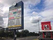
Werrington County is home to a Child Care centre, Werrington County Shopping Village, Caltex and 7- Eleven Petrol stations, Henry Lawson Sports Club, Namatjira Neighbourhood Centre, Tennis, Golf, Squash and other sporting facilities. The suburb is also within a few minutes drive to the St Marys Village Shopping centre located at Charles Hackett Drive which hosts over 40 retailers including Woolworths and Target.[3]
Retailers at Werrington County Shopping Precinct - Dunheved Road
- Australia Post
- KFC
- Eagle Boys Pizza
- Red Rooster
- Thai La-Ong Restaurant
- SUPA IGA
- Ray White Real Estate
- Richardson and Wrench Real Estate
- BWS
- Connor's Gourmet Cuts
- Healthsense Pharmacy
- Werrington County Newsagent
- Werrington County Cafe and Takeaway
- Werrington County Medical Centre
- Pizza Down Under
- Bubbles Florist
- Werrington Swim School
- Werrington Squash & Fitness Centre
- TSG Werrington
Demographics
As per the 2011 Census[4] there were 3,671 residents in Werrington County with an average weekly household income of $1,605 compared to the national average of $1,234. 50.2% were males and 49.8% were females.The median age of people in Werrington County was 34 years. 81.2% of people were born in Australia. The top other countries of birth were England 4.1%, New Zealand 1.4%, Scotland 1.2%, Ireland 0.7% and Philippines 0.6%. The most common ancestries were Australian 32.3%, English 28.2%, Irish 8.4%, Scottish 6.1% and German 2.5%. The top responses for religious affiliation were Catholic 35.8%, Anglican 27.1%, No Religion 16.0%, Presbyterian and Reformed 3.2% and Uniting Church 2.7%. The majority of people (89.2%) only spoke English at home with the other languages spoken being Spanish 0.8%, Greek 0.6%, Arabic 0.6%, Hindi 0.5% and Italian 0.5%.
Schools
Werrington County Public School is located in John Batman Avenue.[5] The primary school was established in 1982. The school was officially opened in 1993 and enjoys a fine reputation within the Penrith District.[6] The nearest High school is Cambridge Park High School in Cambridge Park.
Parks and reserves
Werrington County has 5 parks covering nearly 29% of the total area which include Shaw Park, Ellison Reserve and Werrington Lakes Flora & Fauna Reserve.[7]
Hospital
The nearest Hospital is Nepean Hospital in Penrith which provides multi-speciality Medical services. Werrington County also has a Medical centre at the Werrington County Shopping Village.[8]
Transport
Werrington County has quick and easy access to Penrith by travelling west on Dunheved Road or along Great Western Highway.The suburb is serviced by the Great Western Highway and is also in close proximity to the M4 Western Motorway which can be accessed via Mamre Road for residents travelling towards the Sydney CBD.
Public transport
The nearest railway station is Werrington railway station on the T1 Western Line which provides direct train services to the Sydney CBD.Busways provides 3 services around the Werrington County area. Route 780 travels along Dunheved Road past the Werrington County Shopping Village before travelling to either Penrith or Ropes Crossing[9] while Route 782 travels around Greenbank Drive and Henry Lawson Avenue before travelling to either Penrith or Werrington railway station.[10] Route 785 travels via Cambridge Park to Werrington railway station covering parts of Werrington County.[11]
Governance
At a local government level, Werrington County is part of the north ward of Penrith City Council, represented by Ross Fowler (Mayor of Penrith).At the state level, it is part of the Electoral district of Londonderry, represented by Labor Party member Prue Car. Federally, it is part of the Division of Lindsay, represented by Labor Party member Emma Husar.
Notes and references
- ↑ Australian Bureau of Statistics (31 October 2012). "Werrington County (State Suburb)". 2011 Census QuickStats. Retrieved 16 February 2014.
- ↑ http://www.censusdata.abs.gov.au/census_services/getproduct/census/2011/quickstat/SSC12464
- ↑ http://www.mirvacretail.com.au/centres/st-marys-village/
- ↑ http://www.censusdata.abs.gov.au/census_services/getproduct/census/2011/quickstat/GL_NSW4271?opendocument&navpos=220
- ↑ http://www.werringcty-p.schools.nsw.edu.au/our-school
- ↑ http://house.ksou.cn/school.php?id=7079
- ↑ http://www.myrp.com.au/stats/nsw/werrington_county/2747
- ↑ http://www.whitepages.com.au/business-listing/werrington-county-medical-centre-1250917/werrington-county-nsw
- ↑ https://www.busways.com.au/travelling-with-us/route/780/route-780-penrith-cambridge-park-ropes-crossing-mt-druitt/20140518
- ↑ https://www.busways.com.au/travelling-with-us/route/782/route-782-penrith-st-marys-cambridge-gardens-werrington-station
- ↑ https://www.busways.com.au/travelling-with-us/route/785/route-785-penrith-werrington-station-cambridge-park/20151129