Welda, Kansas
| Welda, Kansas | |
|---|---|
| Census-designated place | |
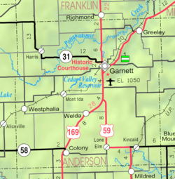 KDOT map of Anderson County (legend) | |
 Welda | |
| Coordinates: 38°10′9″N 95°17′41″W / 38.16917°N 95.29472°WCoordinates: 38°10′9″N 95°17′41″W / 38.16917°N 95.29472°W | |
| Country | United States |
| State | Kansas |
| County | Anderson |
| Area | |
| • Total | 0.93 sq mi (2.42 km2) |
| • Land | 0.93 sq mi (2.40 km2) |
| • Water | 0.008 sq mi (0.02 km2) |
| Elevation | 1,100 ft (300 m) |
| Population (2010) | |
| • Total | 129 |
| • Density | 139/sq mi (53.7/km2) |
| Time zone | Central (CST) (UTC-6) |
| • Summer (DST) | CDT (UTC-5) |
| FIPS code | 20-76425[1] |
Welda is a census-designated place in Anderson County, Kansas, United States. As of the 2010 census, the population was 129.[2]
History
Welda was platted in 1873, soon after the railroad was extended to that point in 1870.[3] The first post office in Welda was established in 1874.[4]
The railroad tracks in Welda have since been converted to a rail trail. The trail is part of the Prairie Spirit Trail State Park.[5]
Geography
Harris is located at 38°10′9″N 95°17′41″W / 38.16917°N 95.29472°W.[6] According to the United States Census Bureau, the CDP has a total area of 0.93 square miles (2.4 km2), of which 0.0077 square miles (0.02 km2), or 0.79%, is water.[2]
Education
Unified School District No. 365 operates Mont Ida Elementary School in Welda and Anderson County Junior-Senior High School in Garnett.[7]
References
- ↑ "American FactFinder". United States Census Bureau. Retrieved 2008-01-31.
- 1 2 "Geographic Identifiers: 2010 Demographic Profile Data (G001): Welda CDP, Kansas". U.S. Census Bureau, American Factfinder. Retrieved May 13, 2013.
- ↑ Blackmar, Frank Wilson (1912). Kansas: A Cyclopedia of State History, Volume 2. Standard Publishing Company. p. 898.
- ↑ "Kansas Post Offices, 1828-1961". Kansas Historical Society. Retrieved 4 June 2014.
- ↑ "Homepage". BikePrairieSpirit.com. Retrieved 17 May 2014.
- ↑ "US Gazetteer files: 2010, 2000, and 1990". United States Census Bureau. 2011-02-12. Retrieved 2011-04-23.
- ↑ "School Campuses." Unified School District No. 365. Retrieved on November 8, 2013.
Municipalities and communities of Anderson County, Kansas, United States | ||
|---|---|---|
| Cities | 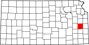 | |
| CDPs | ||
| Unincorporated communities | ||
| Ghost town | ||
| Townships | ||