Lone Elm, Kansas
| Lone Elm, Kansas | |
|---|---|
| City | |
 Location within Anderson County and Kansas | |
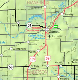 KDOT map of Anderson County (legend) | |
| Coordinates: 38°4′47″N 95°14′33″W / 38.07972°N 95.24250°WCoordinates: 38°4′47″N 95°14′33″W / 38.07972°N 95.24250°W | |
| Country | United States |
| State | Kansas |
| County | Anderson |
| Area[1] | |
| • Total | 0.08 sq mi (0.21 km2) |
| • Land | 0.08 sq mi (0.21 km2) |
| • Water | 0 sq mi (0 km2) |
| Elevation | 1,102 ft (336 m) |
| Population (2010)[2] | |
| • Total | 25 |
| • Estimate (2015)[3] | 24 |
| • Density | 310/sq mi (120/km2) |
| Time zone | Central (CST) (UTC-6) |
| • Summer (DST) | CDT (UTC-5) |
| FIPS code | 20-42425[4] |
| GNIS feature ID | 0478132[5] |
Lone Elm is a city in Anderson County, Kansas, United States. As of the 2010 census, the city population was 25.[6]
History
A post office was opened in Lone Elm in 1879, and remained in operation until it was discontinued in 1956.[7]
Circa 1910, Lone Elm had a bank, a dozen retail establishments, and a population of 175.[8]
Geography
Lone Elm is located at 38°4′47″N 95°14′33″W / 38.07972°N 95.24250°W (38.079750, -95.242515).[9] According to the United States Census Bureau, the city has a total area of 0.08 square miles (0.21 km2), all of it land.[1]
Demographics
| Historical population | |||
|---|---|---|---|
| Census | Pop. | %± | |
| 1930 | 131 | — | |
| 1940 | 97 | −26.0% | |
| 1950 | 82 | −15.5% | |
| 1960 | 69 | −15.9% | |
| 1970 | 66 | −4.3% | |
| 1980 | 55 | −16.7% | |
| 1990 | 32 | −41.8% | |
| 2000 | 27 | −15.6% | |
| 2010 | 25 | −7.4% | |
| Est. 2015 | 24 | [3] | −4.0% |
| U.S. Decennial Census | |||
2010 census
As of the census[2] of 2010, there were 25 people, 12 households, and 7 families residing in the city. The population density was 312.5 inhabitants per square mile (120.7/km2). There were 18 housing units at an average density of 225.0 per square mile (86.9/km2). The racial makeup of the city was 100.0% White.
There were 12 households of which 33.3% had children under the age of 18 living with them, 50.0% were married couples living together, 8.3% had a female householder with no husband present, and 41.7% were non-families. 41.7% of all households were made up of individuals and 33.3% had someone living alone who was 65 years of age or older. The average household size was 2.08 and the average family size was 2.71.
The median age in the city was 46.8 years. 24% of residents were under the age of 18; 0.0% were between the ages of 18 and 24; 20% were from 25 to 44; 32% were from 45 to 64; and 24% were 65 years of age or older. The gender makeup of the city was 44.0% male and 56.0% female.
2000 census
As of the census[4] of 2000, there were 27 people, 12 households, and 9 families residing in the city. The population density was 371.4 people per square mile (148.9/km²). There were 17 housing units at an average density of 233.8 per square mile (93.8/km²). The racial makeup of the city was 100.00% White. Hispanic or Latino of any race were 3.70% of the population.
There were 12 households out of which 25.0% had children under the age of 18 living with them, 75.0% were married couples living together, and 25.0% were non-families. 25.0% of all households were made up of individuals and 16.7% had someone living alone who was 65 years of age or older. The average household size was 2.25 and the average family size was 2.67.
In the city the population was spread out with 18.5% under the age of 18, 14.8% from 25 to 44, 33.3% from 45 to 64, and 33.3% who were 65 years of age or older. The median age was 60 years. For every 100 females there were 107.7 males. For every 100 females age 18 and over, there were 83.3 males.
The median income for a household in the city was $32,500, and the median income for a family was $31,250. Males had a median income of $36,250 versus $0 for females. The per capita income for the city was $18,885. None of the population and none of the families were below the poverty line.
Education
Primary and secondary education
Lone Elm is part of Unified School District 479.[10]
Notable natives
See also
Further reading
- The History Of Anderson County, Kansas, From Its First Settlement To The Fourth Of July, 1876; W.A. Johnson; Kauffman & Iler; 1877.[11]
- Plat Book Of Anderson County, Kansas, Compiled From County Records And Actual Survey; Northwest Publishing Co; 1901.[12]
- Kansas: A Cyclopedia Of State History, Embracing Events, Institutions, Industries, Counties, Cities, Towns, Prominent Persons, Etc; Frank W. Blackmar; Standard Publishing Co; 1912.[13][14][15]
- History Of The State of Kansas; William G. Cutler; A.T. Andreas Publisher; 1883.[16]
References
- 1 2 "US Gazetteer files 2010". United States Census Bureau. Retrieved 2012-07-06.
- 1 2 "American FactFinder". United States Census Bureau. Retrieved 2012-07-06.
- 1 2 "Annual Estimates of the Resident Population for Incorporated Places: April 1, 2010 to July 1, 2015". Retrieved July 2, 2016.
- 1 2 "American FactFinder". United States Census Bureau. Retrieved 2008-01-31.
- ↑ "US Board on Geographic Names". United States Geological Survey. 2007-10-25. Retrieved 2008-01-31.
- ↑ "2010 City Population and Housing Occupancy Status". U.S. Census Bureau. Retrieved March 6, 2011.
- ↑ "Kansas Post Offices, 1828-1961". Kansas Historical Society. Retrieved 4 June 2014.
- ↑ Blackmar, Frank Wilson (1912). Kansas: A Cyclopedia of State History, Volume 2. Standard Publishing Company. p. 184.
- ↑ "US Gazetteer files: 2010, 2000, and 1990". United States Census Bureau. 2011-02-12. Retrieved 2011-04-23.
- ↑ USD 479
- ↑ The History Of Anderson County, Kansas, From Its First Settlement To The Fourth Of July, 1876; 1877.
- ↑ Plat Book Of Anderson County, Kansas, Compiled From County Records And Actual Survey; 1901.
- ↑ Kansas: A Cyclopedia Of State History, Embracing Events, Institutions, Industries, Counties, Cities, Towns, Prominent Persons, Etc - Vol 1; 1912.
- ↑ Kansas: A Cyclopedia Of State History, Embracing Events, Institutions, Industries, Counties, Cities, Towns, Prominent Persons, Etc - Vol 2; 1912.
- ↑ Kansas: A Cyclopedia Of State History, Embracing Events, Institutions, Industries, Counties, Cities, Towns, Prominent Persons, Etc - Vol 3; 1912.
- ↑ History Of The State of Kansas; 1883.
External links
| Wikimedia Commons has media related to Lone Elm, Kansas. |
- City
- School
- Historical
- Maps
- Anderson County Map, KDOT
Municipalities and communities of Anderson County, Kansas, United States | ||
|---|---|---|
| Cities | 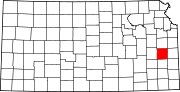 | |
| CDPs | ||
| Unincorporated communities | ||
| Ghost town | ||
| Townships | ||