Weilheim an der Teck
| Weilheim an der Teck | ||
|---|---|---|
 | ||
| ||
 Weilheim an der Teck | ||
Location of Weilheim an der Teck within Esslingen district 
 | ||
| Coordinates: 48°36′54″N 9°32′19″E / 48.61500°N 9.53861°ECoordinates: 48°36′54″N 9°32′19″E / 48.61500°N 9.53861°E | ||
| Country | Germany | |
| State | Baden-Württemberg | |
| Admin. region | Stuttgart | |
| District | Esslingen | |
| Government | ||
| • Mayor | Johannes Züfle | |
| Area | ||
| • Total | 26.51 km2 (10.24 sq mi) | |
| Population (2015-12-31)[1] | ||
| • Total | 10,052 | |
| • Density | 380/km2 (980/sq mi) | |
| Time zone | CET/CEST (UTC+1/+2) | |
| Postal codes | 73231–73235 | |
| Dialling codes | 07023 | |
| Vehicle registration | ES | |
| Website | www.weilheim-teck.de | |

Weilheim an der Teck is a town in the district of Esslingen in Baden-Württemberg in southern Germany. It is situated 7 km southeast of Kirchheim unter Teck, and 13 km southwest of Göppingen.
Weilheim is located north of the Albtrauf and in the foothills of the central Swabian Jura with 2251 ha a relatively large denunciation. This is located in the Swabian Jurassic namely from Lias eta until Late Jurassic, the city is located predominantly on the Middle Jurassic. The surveys show that the distinctive part of Limburg (598 m above sea level. NN), the "mountain" of Weilheim, the Egelsberg (428 m above sea level. NN), both of volcanic origin, as the Tuchbleiche (390 m above sea level. NN). On the east of the city is located the Wolfscherre (537 m above sea level. NN) is more than 50 meters below the summit spur a drinking water reservoir with a 4000 m³ comprehensive high container. Another offshoot of Alb is the preferred southeast Egenfirst (536 m above sea level. NN). The highest point of Weilheim is located at about 800 meters above sea level. NN to the upper edge of the slope of Bosler. The official height of the town hall is 385 meters above sea level. NN. The largest stream is the Lindach. It rises near the 7 km distant ruin Reußenstein in the area of the neighboring Neidlingen over a small waterfall and flows right through Weilheim. After a run of nearly 17 km, it opens in the city of Kirchheim unter Teck in the Lauter (Neckar). Tributaries of her on community denunciation are the Zipfelbach which springs in Randecker Maar. The western edge of the mountain pervades the Ehnisbach right and main headwaters of the Windbach, the well below the municipality is on the Gießnaubach in Kirchheim- Nabern opens in the Lindach. The surroundings of Weilheim show the for Albvorland typical landscape and is active used agriculturally. There are fields and meadows, orchards, and on the slopes of Limburg also vineyards.
History
Finds from prehistoric and ancient times indicate a very early settlement of Weilheim space. The oldest written mention of the place can be found on 1 October 769 in a deed of Lorsch Abbey. In the years 1050 to 1070 founded Berthold II, Duke of Carinthia of the House of Zähringen the Limburg and a provost in Weilheim, which remained during 20 years the headquarter of the House of Zährigen. In 1319 count Ulrich of Aichelberg rose Weilheim to a city, which was fortified and rapidly gained importance because of the market law. 1334 sold Graf Brun of Kirchberg the place for 7,500 guilders to the House of Württemberg. 1432 in turn sold Peter von Liebenstein and his son-in-law Kaspar Schlats the pledge shank to Hans of Wernau. In 1461 a fire in town devastated. 1489 the Peterskirche (peter church) was built with its great variety of equipment in late Gothic style. In the years 1634-1638 the plague ragued in the city, 1505 people died. During the Thirty Years' War Swedish troops looted the place in 1647.
On the marketplace was built in 1777 the town hall. In 2009 a modern designed building with underground parking was erected. At the end of the 19th century industrial development began hesitantely. In 1858 the post Kirchheim-Weilheim was set up. In 1884 a weaving was built, the first larger industrial company. In 1908 the railway Kirchheim (Teck) south-Weilheim (Teck) was put into operation. The passenger transport ended on September 25, 1982, the freight transport ended in 1986. From 1922 to 1924, the urban water supply was established through water pipes. From 1934 to 1937, the A 8 motorway was built, which runs through the district in the far north. From 1938 to Weilheim belonged to the district of Nürtingen, since 1973 to the Esslingen. Since 1975 exists an administration unit with the communities Bissingen, Holzmaden, Neidlingen and Ohmden. On the Bosler, a rock, crashed since 1940 several planes through impact with the abruptly rising mountain.[2]
Incorporations
On 1 January 1972, Hepsisau was incorporated to Weilheim. The coat of arms in from 1952 shows in blue a golden oblique right beams, covered with a natural cherry twig. Hepsisau is located 4 kilometers from Weilheim located on the escarpment and has about 750 inhabitants. The local nobility, the Lords of Hepsisau, are mentioned already in 1237 and 1241 in documents. The municipality occurs in 1504 for the first time.
Transportation
The road L 1200 comes from Neidlingen in the southeast and continues to Kirchheim unter Teck in the northwest. The L 1252 connects westward with Dettingen unter Teck. L 1214 towards Aichelberg leads to the A8. The road L 1213 leads to Gruibingen. From 1908 to 1995 was a railway branch line from Kirchheim (Teck) to Weilheim. Since 1995 Kirchheim (Teck) is the next railway station.

Viticulture
Weilheim is the most south-eastern foothillsof the wine-growing region Württemberg.
Established businesses
- Karl Fischer, earthmoving, demolition, transport work
- Hans Fischer Transport, nationally active forwarding and logistics company
- Wilhelm Kächele, leading manufacturer of specialty rubbers and rubber-metal connections
- Kurt Hack (Euro Tramp trampolines), trampoline manufacturer
Educational institutions
In addition to the Realschule and the elementary and secondary school with Werkrealschule there is with the Limburg school a primary school in the city. A special school completes the education offer. The high school students of the community relate to high school in Kirchheim unter Teck. Furthermore, there are five local municipal kindergarten, the "free kindergarten Weilheim and the forest kindergarten Weilheim. The public library has a stock of about 28,000 media and had in 2012 142,000 loans. Since 1 July 2013, " eLibrary " with e-books was introduced.
Leisure and sports facilities
- The Lindach Stadium, home of the Sports Club Weilheim with adjacent tennis- and football fields, a basketball court, a bike park and a skate park.
- Sports ground Egelsberg (football ground)
- Riding facility (Egelsberg)
Points of interest
Buildings
- The St. Peter's with a lot of fittings was built in 1489 in late Gothic style and is now a cultural monument.
- Kapuzinerhaus
- Bürgerhaus
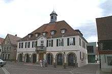
- The town hall on the market square was built 1777

Parson House and Church
Regular events
- Städtlesfest, every year on the first Sunday in July
- Village festival in Hepsisau, every year on the first Sunday in September
- Cherry blossom festival in April
- Advent market, every year on the 2nd Sunday of Advent
Personality
- Freeman Christian Mali (1832-1906), professor and painter
- Emil Paillard (1859-1945), doctor
- Georg Kandenwein, mayor from 1937 to 1972
- Karl Gottlob Dreher (1886-1979), teacher, author of the books Weilheim/Teck, then and now, Volume I + II
Sons and daughters of the city
- Friedrich von Gerok (1786-1865), theologian, General Superintendent of Ludwigsburg, Member of Parliament
- Richard Döcker (1864-1968), architect
Personalities who have worked locally
- Joseph Schwarz (1910-1985), displaced politician (CDU), Member of Parliament, lived in Weilheim and was also council
- Gerhard Dreher (1924-2008), a freelance visual artist, lived for a long time in Weilheim
Literature
- Christoph Bizer: Hepsisau – aus der Geschichte eines Dorfes am Fuße der Alb. Hrsg. von der Stadt Weilheim a. d. Teck, 1987, ISBN 3-9800255-2-7.
- Karl Dreher: Weilheim an der Teck einst und jetzt. A. Gottliebs & J. Oßwalds Buchdruckereien, Kirchheim unter Teck 1939
- Hans Schwenkel: Heimatbuch des Kreises Nürtingen. Band 2, Würzburg 1953, S. 1173–1217.
- Ulrich Marstaller: Die Peterskirche in Weilheim. Konrad Theiss Verlag, Stuttgart 1985, ISBN 3-8062-0436-5.
- Der Landkreis Esslingen (Band 2). Hrsg. vom Landesarchiv Baden-Württemberg i. V. mit dem Landkreis Esslingen, Jan Thorbecke Verlag, Ostfildern 2009, ISBN 978-3-7995-0842-1, Seite 437.
- Manfred Waßner u. a., Die Geschichte der Stadt an der Limburg. Weilheim an der Teck 2007, ISBN 978-3-00-021110-2.