Lenningen
| Lenningen church in Gutenberg | ||
|---|---|---|
 | ||
| ||
 Lenningen church in Gutenberg | ||
Location of Lenningen church in Gutenberg within Esslingen district 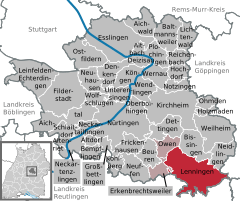
 | ||
| Coordinates: 48°33′0″N 9°28′19″E / 48.55000°N 9.47194°ECoordinates: 48°33′0″N 9°28′19″E / 48.55000°N 9.47194°E | ||
| Country | Germany | |
| State | Baden-Württemberg | |
| Admin. region | Stuttgart | |
| District | Esslingen | |
| Government | ||
| • Mayor | Michael Schlecht | |
| Area | ||
| • Total | 41.44 km2 (16.00 sq mi) | |
| Population (2015-12-31)[1] | ||
| • Total | 8,026 | |
| • Density | 190/km2 (500/sq mi) | |
| Time zone | CET/CEST (UTC+1/+2) | |
| Postal codes | 73252 | |
| Dialling codes | 07026 | |
| Vehicle registration | ES | |
| Website |
www | |

Lenningen is a town in the district of Esslingen in Baden-Württemberg in Germany.
Neighbour communities
Those are in the east Wiesensteig (district of Göppingen), in the south Römerstein and Grabenstetten (both district of Reutlingen), in the west Erkenbrechtsweiler, in the northwest Owen and in the north Bissingen an der Teck and Neidlingen (all district of Esslingen).
Transportation
Verkehr
Teckbahn from Wendlingen am Neckar via Kirchheim unter Teck ends in Obelenningen. The Königlich Württembergischen Staats-Eisenbahnen built the stations in Unter- and Oberlenningen 1899 as unity stations.[2] Nowadays the per hour circulating Regionalbahnen of DB Regio im the area of Lenningen stop at three stations: Oberlenningen, Unterlenningen and Brucken.
Parallel to Teckbahn in Lenningen runs A-road Bundesstraße 465 Biberach–Kirchheim. On this road you can reach five miles away junction Kircheim-east of A 8 Stuttgart–München.
Notable people from Lenningen
- Adolf Scheufelen (1864–1941), engineer and entrepreneur
- Karl-Erhard Scheufelen (1903–1992), entrepreneur
- Klaus-Heinrich Scheufelen (1913–2008), engineer, entrepreneur and politician
- Karl Scheufelen (1823–1902), founder of paper factory Scheufelen
- Julius von Jan (1897–1964), parson and resistance fighter against nazism, became 1935 parson in Oberlenningen
 Oberlenningen, station
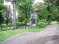 Oberlenningen, cemetery
Brucken
Brucken was first mentioned 1123 and was united with Unterlenningen 1939. eingemeindet. Brucken has 1026 Einwohner (Stand 31. Dezember 2012).
Gutenberg
In 1285 Gutenberg was first mentioned. It received the rights of a town during Thirty Years' War the place lost so many people, they lost town rights. Gutenberg nowadays has 676 inhabitants (Stand 31. Dezember 2012).
Hochwang
After world War II many refugees came to the Lenningen valley from former Eastern German regions. First they came in houses of residents. Because ground is small in the valley, in 1951 the managers of papermill Scheufele thought we need buildings for these people and workers. So the idea was born to build houses on the Swabian Alb. Work started with building a road, more than 100 people worked for 30 months. The road was opened 1954. Building the houses started in September 1952, till 1971 184 houses with 312 apartments, 62 garages were built. The total cost was 9,2 Mio. DM (4,7 Mio. €). At this time the population of Hochwang was 1/3 residents and 2/3 refugees. Nowadays 681 people live in Hochwang (Stand 31. Dezember 2012).
Oberlenningen
Around 1100 Oberlenningen was first mentonned Oberlenningen has 2.507 inhabitants (Stand 31. Dezember 2012)
Schlattstall
Schlattstall was first mentioned 1384. Since 1. January 1971 it belongs to Oberlenningen. In Schlattstall live today 168 people (Stand 31. Dezember 2012).
Schopfloch
Schopfloch was first mentioned in 1152. In the Thirty Years War, the place was so destroyed that the number of inhabitants fell from 100 to 40. As of 31 December 2012, Schopfloch has 683 inhabitants.
Unterlenningen
Unterlenningen was a unit with Oberlenningen. They separated 1353, reunion was 1975 in Unterlenningen live 2.223 Menschen (Stand 31. Dezember 2012).
 Brucken
References
- ↑ "Gemeinden in Deutschland nach Fläche, Bevölkerung und Postleitzahl am 30.09.2016". Statistisches Bundesamt (in German). 2016.
- ↑ Rainer Stein (1996), "Der württembergische Einheitsbahnhof auf Nebenbahnen" (in German), Eisenbahn-Journal Württemberg-Report (Fürstenfeldbruck: Merker) Band 1 (V/96): pp. 80–83, ISBN 3-922404-96-0
External links
![]() Media related to Lenningen at Wikimedia Commons
Media related to Lenningen at Wikimedia Commons