Bissingen an der Teck
| Bissingen an der Teck | ||
|---|---|---|
| ||
 Bissingen an der Teck | ||
Location of Bissingen an der Teck within Esslingen district 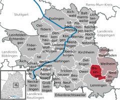
 | ||
| Coordinates: 48°35′58″N 9°29′33″E / 48.59944°N 9.49250°ECoordinates: 48°35′58″N 9°29′33″E / 48.59944°N 9.49250°E | ||
| Country | Germany | |
| State | Baden-Württemberg | |
| Admin. region | Stuttgart | |
| District | Esslingen | |
| Government | ||
| • Mayor | Marcel Musolf | |
| Area | ||
| • Total | 17.06 km2 (6.59 sq mi) | |
| Population (2015-12-31)[1] | ||
| • Total | 3,481 | |
| • Density | 200/km2 (530/sq mi) | |
| Time zone | CET/CEST (UTC+1/+2) | |
| Postal codes | 73266 | |
| Dialling codes | 07023 | |
| Vehicle registration | ES | |
| Website | www.bissingen-teck.de | |

Bissingen is a municipality in the district of Esslingen in Baden-Württemberg in southern Germany.
Geographical location
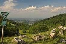
Bissingen lies at the foot of the Swabian Jura, the district Ochsenwang on the Alb plateau. The municipality covers an altitude of 384 m on the border with Kirchheim unter Teck-Nabern to 830 m in "Brucker Hölzle", which is at the same time the highest point of Stuttgart (region).
Outline
The municipality Bissingen an der Teck consists of the nucleus and the village Ochsenwang.
Neighboring communities
Adjacent municipalities are Kirchheim unter Teck in the north, Weilheim an der Teck in the east, Neidlingen in the southeast, Lenningen in the south, Owen in the West and Dettingen unter Teck in the northwest (all Esslingen district).
History
As one of the first places in the district of Esslingen, Bissingen is documented in the year 769. iI appeared in the written tradition of the Lorsch Codex. From the 11th century to the mid-12th century Bissingen belonged to the House of Zähringen, then to the Duckes of Teck. The place came to Württemberg in 1326. Bissingen belonged to Oberamt Kirchheim, this became in 1938 the district of Nürtingen. In the course of the district reform 1973 Bissingen came to district Esslingen. On the eastern edge are the remains of the Wasserburg (water castle] Bissingen.
Incorporations
On January 1, 1975 Ochsenwang was incorporated to Bissingen.
Demographics
The numbers of inhabitants are census results (¹) or officialextapolations of statistical office Stuttgart.
| Stichtag | Einwohnerzahl |
|---|---|
| 3. December 1834 ¹ | 1.871 |
| 1. December 1871 ¹ | 1.685 |
| 1. December 1900 ¹ | 1.602 |
| 17. May 1939 ¹ | 1.542 |
| 13. September 1950 ¹ | 2.078 |
| 6. June 1961 ¹ | 2.173 |
| 27. May 1970 ¹ | 2.583 |
| 25. May 1987 ¹ | 3.271 |
| 31. December 1995 | 3.476 |
| 31. December 2000 | 3.691 |
| 31. December 2005 | 3.659 |
| 31. December 2010 | 3.523 |
Points of interest
Museums
In Ochsenwang is the Mörike House Ochsenwang, where Eduard Mörike lived in 1832.
Music
Bissingen has a music club for brass bands, divided into youth and master chapel. Bissingen has adjacent to this a glee club. The MGV (Männergesangsverein) is divided into a children's choir (the "Kibize"), a mixed chorus ("Fresh Wind") and a men's choir.
Orchards as formative landscape
Bissingen is surrounded by extensive orchards. In order to maintain these habitats, the Horticultural Association Bissingen takes care of old tree stocks to ensure that landscape and varieties are preserved for future generations. This is done through the support of community-own orchards and the establishment of a mother garden with old varieties. [2]
Natural monuments
The "Randecker Maar" in the district Ochsenwang is a former volcanic vent of the Swabian volcano.
Notable people from Bissingen an der Teck
- Johann Viktor Gruol the younger (?–1871), organ builder
- Georg Ehni (1828–1904), Member of Reichstag
- Robert von Gaupp, (1836–1908), state councilor, Member of Landtag
- Friedrich Goll, (1839–1911), organ builder
- Wilhelm Ederle, (1901–1966), doctor