Washington Channel
| Washington Channel | |
|---|---|
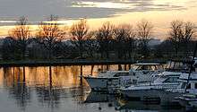 View of the Washington Channel from the Southwest Waterfront. | |
| Country | United States |
| Basin | |
| Main source |
Tidal Basin 0 feet (0 m) |
| River mouth |
Anacostia River at Hains Point 0 feet (0 m) |
| River system | Potomac River |
| Physical characteristics | |
| Length | 2 miles (3.2 km) |
The Washington Channel is a channel that parallels the Potomac River in Washington, D.C. It is located between the Southwest Waterfront on the east side and East Potomac Park on the west side. The channel is two miles long, receives outflow from the Tidal Basin at its north end, and empties into the Anacostia River at Hains Point at its south end. The channel's depth ranges from 8.8 feet (2.7 m) to 23 feet (7.0 m).[1][2]
The Washington Channel's east bank is lined with restaurants, inns, and marinas including Washington Marina, Gangplank Marina (the only liveaboard marina in the District of Columbia), and Capital Yacht Club. The Maine Avenue Fish Market is situated at the north end of the channel, south of the 14th Street Bridge complex. The Women's Titanic Memorial, Fort Lesley J. McNair, the National Defense University, and James Creek Marina are located near the south end of the channel. As of August 2010, the USS Sequoia—a former United States presidential yacht—is docked at a pier in the Washington Channel.[3]
Transfer of responsibility

On June 16, 2010, District of Columbia Delegate Eleanor Holmes Norton introduced a bill (H
References
- ↑ "Washington Channel". Geographic Names Information System. United States Geological Survey. Retrieved May 5, 2010.
- ↑ United States Coast Pilot. 3 (43rd ed.). Washington, D.C.: National Ocean Service. 2010. p. 318. Retrieved May 5, 2010.
- ↑ "U.S.S. Sequoia - Directions". Sequoia Presidential Yacht Group. Retrieved August 10, 2010.
- ↑ Bill summary and status at THOMAS: H
.R .. 5545 - ↑ Neibauer, Michael (July 20, 2010). "Norton's SW Waterfront Bill Passes". WBJBizBeat. Washington Business Journal. Retrieved August 10, 2010.
- 1 2 3 2010 Congressional Record, Vol. 156, Page H5743 (July 20, 2010).
External links
| Wikimedia Commons has media related to Washington Channel. |
Coordinates: 38°52′16.9″N 77°1′14.9″W / 38.871361°N 77.020806°W