Middle Creek (Toms Creek)
| Middle Creek (Toms Creek) | |
 Monocacy River watershed | |
| Country | United States |
|---|---|
| States | Pennsylvania, Maryland |
| Counties | Adams, Frederick |
| Mouth | Toms Creek |
| - coordinates | 39°41′05″N 77°17′46″W / 39.6846°N 77.2962°WCoordinates: 39°41′05″N 77°17′46″W / 39.6846°N 77.2962°W |
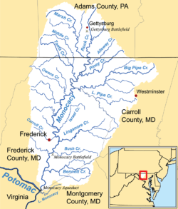
Middle Creek is a 17.1-mile-long (27.5 km)[1] tributary of Toms Creek in Pennsylvania and Maryland in the United States.[2]
Middle Creek is born on the eastern slope of the Blue Ridge Mountains, and from there flows through Adams County, Pennsylvania and Frederick County, Maryland to join Toms Creek near Emmitsburg.[2]
Water from Middle Creek flows via Toms Creek, the Monocacy River, and the Potomac River to Chesapeake Bay and eventually the Atlantic Ocean.
| Intersections, north-to-south | |||||
| Intersection | Location/Description | Coordinates | |||
|---|---|---|---|---|---|
| Source | South Mountain | ||||
| Perennial point[3] | 39°48′05″N 77°26′29″W / 39.80132°N 77.44149°W | ||||
| confluence | Swamp Creek | ||||
| confluence | Spring Run | ||||
| confluence | Muddy Run | ||||
| state line | Adams County, Pennsylvania & Frederick County, Maryland | ||||
| mouth | Toms Creek | ||||
See also
References
- ↑ U.S. Geological Survey. National Hydrography Dataset high-resolution flowline data. The National Map, accessed August 15, 2011
- 1 2 Gertler, Edward. Keystone Canoeing, Seneca Press, 2004. ISBN 0-9749692-0-6
- ↑ The National Map (Map). National Hydrography Dataset. USGS. Retrieved 2011-06-28.
This article is issued from Wikipedia - version of the 9/11/2016. The text is available under the Creative Commons Attribution/Share Alike but additional terms may apply for the media files.