Marsh Creek (Monocacy River)
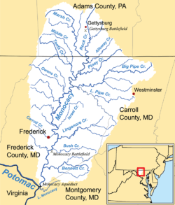
Watershed map showing Marsh Creek
Marsh Creek is a 26.6-mile-long (42.8 km)[1] tributary of the Monocacy River in south-central Pennsylvania and north-central Maryland in the United States.[2]
Marsh Creek and Rock Creek join below Gettysburg and the Gettysburg Battlefield to form the Monocacy River. The height of land between Marsh and Rock creeks is the site of the Battle of Gettysburg.[2]
See also
References
- ↑ U.S. Geological Survey. National Hydrography Dataset high-resolution flowline data. The National Map, accessed August 15, 2011
- 1 2 Gertler, Edward. Keystone Canoeing, Seneca Press, 2004. ISBN 0-9749692-0-6
External links
Coordinates: 39°43′6″N 77°13′38″W / 39.71833°N 77.22722°W
This article is issued from Wikipedia - version of the 9/11/2016. The text is available under the Creative Commons Attribution/Share Alike but additional terms may apply for the media files.