Wana, West Virginia
| Wana | |
|---|---|
| Unincorporated community | |
 Wana  Wana Location within the state of West Virginia | |
| Coordinates: 39°42′13″N 80°17′54″W / 39.70361°N 80.29833°WCoordinates: 39°42′13″N 80°17′54″W / 39.70361°N 80.29833°W | |
| Country | United States |
| State | West Virginia |
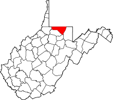
| County | Monongalia |
| Time zone | Eastern (EST) (UTC-5) |
| • Summer (DST) | EDT (UTC-4) |
| ZIP codes | 26590 |
Wana is an unincorporated community in northwestern Monongalia County, West Virginia, USA. It lies along West Virginia Route 7 northwest of the city of Morgantown, the county seat of Monongalia County.[1] Its elevation is 1,030 feet (314 m).[2] Although it is unincorporated, it has a post office, with the ZIP code of 26590.[3]
References
- ↑ Rand McNally. The Road Atlas '08. Chicago: Rand McNally, 2008, p. 112.
- ↑ Geographic Names Information System Feature Detail Report, Geographic Names Information System, 1980-06-27. Accessed 2008-03-29.
- ↑ Zip Code Lookup
This article is issued from Wikipedia - version of the 7/28/2016. The text is available under the Creative Commons Attribution/Share Alike but additional terms may apply for the media files.