105 Street, Edmonton
| Walterdale Hill, Queen Elizabeth Park Road | |
| Maintained by | the City of Edmonton |
|---|---|
| Length | 3.7 km (2.3 mi) |
| Location | Edmonton |
| South end | Saskatchewan Drive |
| Major junctions | Rossdale Road, 97 Avenue, Jasper Avenue, 104 Avenue, 107 Avenue |
| North end | 108 Avenue |
105 Street is an arterial road in Downtown Edmonton, Alberta, Canada. It starts across the North Saskatchewan River from Downtown, as one-way streets Walterdale Hill and Queen Elizabeth Park Road, which join and continue north on Walterdale Bridge. At 100 Avenue, 105 Street becomes a two-way street, and continues through Downtown past MacEwan University.
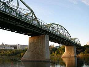
Walterdale Bridge carrying 105 Street.
Interchanges and intersections
This is a list of major intersections, starting at the south end of 105 Street.[1]
As Queen Elizabeth Park Road
| Direction | Intersecting road | Current intersection type | Coordinates |
|---|---|---|---|
| East-West | Saskatchewan Drive | 3-way junction | 53°31′27″N 113°29′37″W / 53.52417°N 113.49361°W |
| Southeast-Northwest | (driveways) | At-grade | 53°31′27″N 113°29′53″W / 53.52417°N 113.49806°W |
| East-West | Queen Elizabeth Park access | At-grade | 53°31′36″N 113°30′10″W / 53.52667°N 113.50278°W |
| Walterdale Hill / 105 Street | At-grade (traffic lights) | 53°31′36″N 113°30′12″W / 53.52667°N 113.50333°W | |
| 107 Street | At-grade | 53°31′35″N 113°30′15″W / 53.52639°N 113.50417°W |
As Walterdale Hill
| Direction | Intersecting road | Current intersection type | Coordinates |
|---|---|---|---|
| West-East | 109 Street / Saskatchewan Drive | At-grade (traffic lights) | 53°31′26″N 113°30′43″W / 53.52389°N 113.51194°W |
| Southwest-Northeast | Old Fort Hill Road (106A Street) | At-grade | 53°31′28″N 113°30′20″W / 53.52444°N 113.50556°W |
| South-North | 91 Avenue / Queen Elizabeth Park Road | At-grade (traffic lights) | 53°31′36″N 113°30′12″W / 53.52667°N 113.50333°W |
| 105 Street | (Walterdale Bridge) | 53°31′43″N 113°30′8″W / 53.52861°N 113.50222°W |
As 105 Street
| Direction | Intersecting road | Current intersection type | Coordinates |
|---|---|---|---|
| South-North | River Valley Road / Rossdale Road | At-grade (traffic lights) | 53°31′50″N 113°30′4″W / 53.53056°N 113.50111°W |
| 97 Avenue | At-grade (traffic lights) | 53°32′2″N 113°30′4″W / 53.53389°N 113.50111°W | |
| 100 Avenue | At-grade (traffic lights) | 53°32′20″N 113°30′4″W / 53.53889°N 113.50111°W | |
| Jasper (101) Avenue | At-grade (traffic lights) | 53°32′20″N 113°30′4″W / 53.53889°N 113.50111°W | |
| 104 Avenue | At-grade (traffic lights) | 53°32′46″N 113°30′4″W / 53.54611°N 113.50111°W | |
| 105 Avenue | T-junction (train bells and traffic lights) | 53°32′52″N 113°30′4″W / 53.54778°N 113.50111°W | |
| 107 Avenue (of Nations) | At-grade (train bells and traffic lights) | 53°33′5″N 113°30′4″W / 53.55139°N 113.50111°W |
References
- ↑ "City of Edmonton map utility". Archived from the original on 2009-06-25. Retrieved 2009-06-23.
This article is issued from Wikipedia - version of the 9/8/2016. The text is available under the Creative Commons Attribution/Share Alike but additional terms may apply for the media files.