Wadena, Indiana
| Wadena | |
|---|---|
| Unincorporated community | |
|
A street corner in the small town of Wadena | |
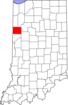 Benton County's location in Indiana | |
 Wadena Freeland Park's location in Benton County | |
| Coordinates: 40°41′36″N 87°16′36″W / 40.69333°N 87.27667°WCoordinates: 40°41′36″N 87°16′36″W / 40.69333°N 87.27667°W | |
| Country | United States |
| State | Indiana |
| County | Benton |
| Township | Union |
| Named for | Wadena, Minnesota |
| Elevation[1] | 794 ft (242 m) |
| Population (2009) | |
| • Total | 20 |
| ZIP code | 47944 |
| FIPS code | 18-79424[2] |
| GNIS feature ID | 445342 |

Wadena is an unincorporated community in Union Township, Benton County, Indiana. It is part of the Lafayette, Indiana Metropolitan Statistical Area.
History
Wadena was founded by John Swan and named after Wadena, Minnesota, a town Swan had recently visited and found pleasing.[3] The name derives from an Ojibwa term meaning "little round hill".[4] The town was situated along a north/south rail line constructed through Benton County in the 1880s, originally operated as the Chicago and Great Southern Railway and later as the Chicago and Indiana Coal Railway, the Chicago and Eastern Illinois Railroad, and ultimately the Chicago, Attica and Southern Railroad which maintained the line until its abandonment in the 1940s. The line was also commonly known as the Coal Road and the Dolly Varden Line.[5]
In the early 20th century, four Wadena residents gained national repute as professional baseball players:[3]
- Doc Crandall: A utility pitcher for the New York Giants (1906-1914), he then joined St. Louis in the Federal League (1914-1918), then Los Angeles (Coast League).
- Karl Crandall: Played several years for a Memphis, Tennessee, team, played three years with the Indianapolis American Association (1913-1916) and then entered the Coast League.
- Arnold Crandall: Pitched for the Buffalo, New York, International League team in 1921.
- Cy Williams: outfielder for the Chicago Cubs (1913-1916), then joined the Philadelphia Nationals.
Wadena currently consists of several private residences and a defunct Baptist church that burned down. A monument east of town commemorates Wadena School, which served the township's students from 1895 to 1961.
Geography
Wadena is located at 40°41′36″N 87°16′36″W / 40.69333°N 87.27667°W along Benton County Road 600 North in Union Township, midway between 200 East and 300 East.
Big Pine Creek Ditch begins in the fields just west of town and flows southeast approximately six miles to Big Pine Creek. Carpenter Creek, which meets the Iroquois River about 14 miles to the north, begins northeast of Wadena. Mount Nebo, the highest point in Benton County, stands a little less than two miles to the east.[6]
References
- ↑ "US Board on Geographic Names". United States Geological Survey. 2007-10-25. Retrieved 2008-01-31.
- ↑ "American FactFinder". United States Census Bureau. Retrieved 2008-01-31.
- 1 2 Birch, Jesse Setlington (1942) [1928]. "Unincorporated community s of the County". History of Benton County and Historic Oxford. Oxford, Indiana: Craw & Craw. pp. 200–201.
- ↑ Allison, Harold (1986). "Appendix: Indiana Indian Place Names". The Tragic Saga of the Indiana Indians. Paducah, Kentucky: Graphic Design of Indiana. p. 314. ISBN 0-938021-07-9.
- ↑ Elmer G., Sulzer (1970). Ghost Railroads of Indiana. Indianapolis: Jones and Co.
- ↑ "Topographic map of Wadena area". The National Map. USGS via MSR Maps. Retrieved 2008-12-12.
Municipalities and communities of Benton County, Indiana, United States | ||
|---|---|---|
| Towns | ||
| Townships | ||
| Unincorporated communities | ||
| Footnotes | ‡This populated place also has portions in an adjacent county or counties | |