Vorskla River
| Vorskla Ворскла | |
|---|---|
 Vorskla in Poltava | |
| Country | Russia, Ukraine |
| Basin | |
| Main source | Belgorod Oblast, Russia |
| River mouth | Dnieper, Ukraine |
| Basin size | 14,700 km2 (5,700 sq mi) |
| Physical characteristics | |
| Length | 464 km (288 mi) |
The Vorskla River (Russian: Ворскла; Ukrainian: Ворскла, Polish: Worskla, German: Hureanus), located in Russia and northeastern Ukraine, is a south-flowing tributary of the Dnieper River.
An ancient fort, thought to be Gelonos, is on the Vorskla south of Okhtyrka. In 1399, the Battle of the Vorskla River was fought in the area. In 1709, the city of Poltava, on the banks of the Vorskla River, was besieged by Charles XII.
It has a length of 464 km, a basin area of 14,700 km² and is mostly navigable between its delta and Kobelyaky.
Tributaries of the river are: (Right): Vorsklytsia, Boromlya, (Left): Merlo, Kolomak, and Tahamlik.
Large cities located on the river are: Poltava, the capital of the Poltava Oblast, Okhtyrka and Kobeliaky.
Flora and fauna
In the river there are more than 50 species of fish, most of which are carps and pikes, breams, rudds, roaches, minnows, catfish.
Fauna is represented by hares, foxes, in the woods you can meet roe deer and wild boar, a great variety of birds: wild duck, gray heron, partridge, pheasant.
Along the banks of the river there are large wooded areas, as coniferous (mostly on the left bank) and deciduous forests.
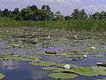 White lilies of the Vorskla River in July 2005
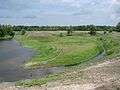 Vorskla River near Khukhra village
 Worska River near Opishnya
 Vorskla River near Novi Sanzary
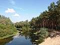 Vorskla River near Novi Sanzary
External links
| Wikimedia Commons has media related to Vorskla River. |
| Tributaries1 | 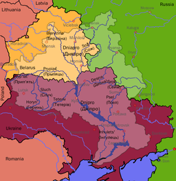 | |
|---|---|---|
| Reservoirs |
| |
| Hydroelectric stations | ||
| Canals |
| |
| Cities | ||
1 Italics indicate left tributaries | ||
Coordinates: 48°54′15″N 34°07′18″E / 48.90417°N 34.12167°E