North Crimean Canal
| North Crimean Canal | |
|---|---|
|
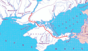
map of the canal | |
| Specifications | |
| Length | 250.1 miles (402.5 km) |
| History | |
| Former names | North Crimean Canal of the LKSMU |
| Original owner | State government |
| Principal engineer | Ukrvodbud |
| Other engineer(s) | Ukrdiprovodbud |
| Date of act | September 21, 1950 |
| Construction began | 1961 |
| Date completed | December 29, 1975 |
| Geography | |
| Start point | Tavriysk |
| End point | Kerch city water treatment facilities |
| Branch(es) |
Krasnoznamiansky Canal Soyedenitelny Canal |
| Connects to | Dnieper River |
The North Crimean Canal (Russian: Северо-Крымский канал, Ukrainian: Північно-Кримський канал; in the Soviet Union – North Crimean Canal of the Lenin's Komsomol of Ukraine) is a land improvement canal for irrigation and watering of Kherson Oblast in southern Ukraine, and the Crimean peninsula. The canal also has multiple branches throughout Kherson Oblast and the Crimean peninsula.
The construction preparation started in 1957 soon after the transfer of Crimea of 1954. The main project works took place between 1961 and 1971 and had three stages. The construction was conducted by the Komosomol members sent by the Komsomol travel ticket (Komsomolskaya putyovka) as part of shock construction projects and accounted for some 10,000 "volunteer" workers.

Overview
The canal begins at the city of Tavriysk, where it draws from the Kakhovka Reservoir, and stretches out in a generally southeasterly direction, terminating at the small village of Zelnyi Yar (Lenine Raion); from there, a pipeline carries water to supply the city of Kerch at the eastern extreme of the Crimean peninsula. Seven water reservoirs lie along the main canal, which is 402.6 km (250.2 mi) in length. Water flows by gravity from Tavriysk to Dzhankoy, where it is elevated by four pump stations to a height of over 100 m (330 ft) to energize its continued downstream flow. In Crimea, numerous smaller canals branch off the main channel, including the Razdolne rice canal, Azov rice canal, Krasnohvardiiske distribution canal, Uniting canal, and Saky canal; through these, water is also supplied to the city of Simferopol.[1]
The idea to construct the canal was raised in the 19th century, particularly by the Russian-Finnish botanist Christian von Steven. But it was not until after World War II when the decision was finally adopted on September 21, 1950 by the Central Committee of the Communist Party of the Soviet Union and the Government of the Soviet Union. The decision was to build the Kakhovka Hydro Electric Station, South Ukrainian and North Crimean canals. In 1951 the Soviet postal service released a commemorative post stamp where the North Crimean Canal was categorized as one of the Great Construction Projects of Communism.
After the Russian annexation of Crimea during the 2014 Crimean crisis, Ukrainian authorities greatly reduced the volume of water flowing into Crimea via the canal, citing a huge outstanding debt on water supplies owed by the peninsula. This caused the peninsula's agricultural harvest which is heavily dependent on irrigation to fail in 2014.[2][3] A Ukrainian source claims that there is water in the canal, but Russian authorities turned the pumps off on purpose for political reasons.[4]
Crimean water sources are being connected to the North Crimean Canal to replace the former Ukrainian sources. The objective is to restore irrigation and urban supplies to the Kerch Peninsula and to smaller communities on the east coast of Crimea.[5] In 2014, the reservoir was built to store water of the rivers of the Eastern Crimea near village Novoivanovka, Nyzhnohirskyi Raion. The North Crimean Canal is connected with The Novoivanovka reservoir. [6]
Gallery
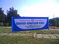 Sign with information about the canal
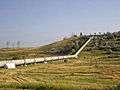 Sewer - branch of North Crimean Canal near Simferopol
Branches
Kherson Oblast
- Kakhovka Canal
- Krasnoznamensky Canal
Crimea
- Razdolne Rice Canal
- Azov Rice Canal
- Uniting Canal
- Saky Canal
- Krasnohvardiyske distribution branch
Water reservoirs
- Mizhhirne
- Feodosiyske
- Frontove
- Leninske
- Samarlynske
- Starokrymske
- Stantsiyne (Kerchenske)
External links
- Berezovsky, E. Северо-Крымский - дорога куда? (North-Crimean is road to where?). "Ekologiya i Mir" (Crimean Republican Association).
- Nina Bogutskaya, Jennifer Hales Crimean Peninsula. Freshwater Ecoregions of the World.
References
- ↑ Tymchenko, Z. North Crimean Canal. History of construction. Ukrayinska Pravda. May 13, 2014 (Krymskiye izvestiya. November 2012)
- ↑ "Russia fears Crimea water shortage as supply drops". BBC News. 2014-04-25. Retrieved 2014-04-26.
- ↑ "Crimea Rice Crop Fails Over Water War With Ukraine". The Moscow Times. 6 May 2014. Retrieved 22 March 2015.
- ↑ "Anonymous пояснили, що воду Криму відключила влада РФ" [Anonymous explained that the Russian authorities turned off water in Crimea]. Ukrayinska Pravda (in Ukrainian). 27 April 2014. Retrieved 21 June 2015.
- ↑ http://en.voicesevas.ru/news/crimea/3976-new-pipelines-start-supplying-fresh-water-to-crimea.html
- ↑ Dnepr is no longer needed (in Russian)
Coordinates: 46°45′52″N 33°23′41″E / 46.76444°N 33.39472°E