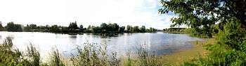
Ubort River
Ubort River (Russian: Уборть) is a river in Zhytomyr Oblast (Ukraine) and Homiel Voblast (Belarus), a right tributary to the Pripyat River, in the Dnieper river basin.[1]
The Ubort River is fed mostly by snow melt (~70%), and peaks during the Spring run-off, usually mid March to early May, and maintains an even, albeit lower, flow during the summer months. It can freeze up as early as mid November or as late as January, and the ice breaks up as early as mid February or as late as mid April.
Course
The Ubort River originates in the hills above and south of the village of Andreyevichi[2] in Zhytomyr Oblast. It arises at 50°42′36″N 27°53′56″E / 50.71000°N 27.89889°E, elevation 207 m., from a series of small creeks flowing westward off of the Simony Hills, elevation 222 m, and northeastward off of the Marynivka Hills, elevation 225 m. The river flows north past Yemilchyne and Olevsk, thence across the international border into Belarus near Borovoye[3] (Баравое). It then flows northeast and north past Lelchytsy, and Moiseyevichi, before entering the Pripyat at Pyetrykaw. The mouth of the river is at 52°06′05″N 28°27′56″E / 52.10139°N 28.46556°ECoordinates: 52°06′05″N 28°27′56″E / 52.10139°N 28.46556°E with an elevation of 120 meters.
The principle tributaries[4] of the Ubort are the 67 km Prega River (Перга) with its mouth at 51°24′00″N 027°52′57″E / 51.40000°N 27.88250°E in the Ukraine, and the 58 km Svidovets (Свидовець) with its mouth at 51°42′55″N 028°17′28″E / 51.71528°N 28.29111°E in Belarus.[5]
The river has a low incline dropping only 87 meters over its 292 kilometer length. The result is a meandering river with lots of swamps and oxbox lakes. The area of its drainage basin is 5,820 square kilometres (2,247 sq mi). The average annual flow of water at the mouth of the Ubort River is 24.4 Cubic metres per second.
History
The name appears in Latin as Hubort in a 1412 survey document. Some maps in the seventeenth and eighteenth centuries mark it as the Олевская (Olevskaya) or in Polish Olewsko, as being of the town of Olevsk. The origin of the name Ubort is obscure, but seems to be related to the use of boards (ubort) in making artificial hollow trees for honey bees.[6]
In July 1941, between 30 and 40 Jews from Olevsk were taken to the Ubort River, where they were humiliated and tortured; some of them were murdered in the pogrom.[7]
It was contaminated during the Chernobyl disaster.
References
- ↑ "Uborć" (in Polish). in Słownik geograficzny Królestwa Polskiego (Geographical Dictionary of the Kingdom of Poland) volume XII, page 734, (1892)
- ↑ Andreyevichi (Approved) at GEOnet Names Server, United States National Geospatial-Intelligence Agency
- ↑ Baravoye (Approved) at GEOnet Names Server, United States National Geospatial-Intelligence Agency
- ↑ Other tributaries are the Бересток, Мала Глумча, Зольня, Телина, Угля, Мудрич, Божанка, and Силець.
- ↑ "Świdówka (Svidovets of the Dnieper)" (in Polish). in Słownik geograficzny Królestwa Polskiego (Geographical Dictionary of the Kingdom of Poland) volume XI, page 649, (1890)
- ↑ Жучкевич, Вадим Андреевич (Zhuchkevich, Vadim A.) (1974). Краткий топонимический словарь Белоруссии (Short toponymic dictionary of Belarus) (in Russian). Наука и техника.
- ↑ McBride, Jared (July 20, 2016). "Ukrainian Holocaust Perpetrators Are Being Honored in Place of Their Victims". The Tablet. Retrieved July 22, 2016.
Books
- Khvagina, T. A. (2005). Polesye: from the Bug to the Ubort' (in Belarusian, Russian, and English). Minsk: Vysheysha shkola. ISBN 985-06-1153-7.
- Gerlach, Thomas (2009). Ukraine: Zwischen den Karpaten und dem Schwarzen Meer (Ukraine: Between the Carpathians and the Black Sea) (in German). Berlin: Trescher. ISBN 978-3-89794-152-6.