Virginia State Route 231
| ||||
|---|---|---|---|---|
 | ||||
| Route information | ||||
| Maintained by VDOT | ||||
| Length: | 49.82 mi[1] (80.18 km) | |||
| Existed: | 1933 – present | |||
| Major junctions | ||||
| South end: |
| |||
|
| ||||
| North end: |
| |||
| Location | ||||
| Counties: | Albemarle, Louisa, Orange, Madison, Rappahannock | |||
| Highway system | ||||
| ||||

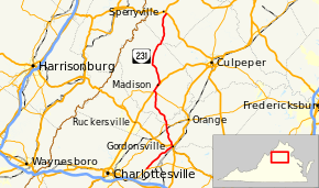
State Route 231 (SR 231) is a primary state highway in the U.S. state of Virginia. The state highway runs 49.82 miles (80.18 km) from SR 22 in Cismont north to U.S. Route 522 (US 522) near Sperryville. SR 231 forms part of the connection between Charlottesville and Gordonsville, where the highway meets US 15 and US 33. The state highway also serves as the main north–south highway of Madison County, connecting the county seat of Madison, where the highway intersects US 29, with Gordonsville to the south and passing through the foothills of the Blue Ridge Mountains to the north.
Almost all of SR 231 is a Virginia Byway.
Route description
SR 231 begins at an acute intersection with SR 22 (Louisa Road) at the southern end of the village of Cismont in northeastern Albemarle County. The state highway heads northeast as Gordonsville Road through the village, which contains historic Grace Episcopal Church. SR 231 parallels the eastern flank of the Southwest Mountains and passes through Cash Corner, the site of the historic plantation Castle Hill. The state highway becomes Gordon Avenue as it passes through the northwestern corner of Louisa County just south of the Albemarle–Louisa–Orange county tripoint. Shortly after entering Orange County, SR 231 enters the town of Gordonsville, where the highway meets US 15 and US 33 at Gordonsville Circle. Southbound US 15 and eastbound US 33 follow the southeast leg of the roundabout, Main Street, into the center of town. Northbound US 15 follows Gordon Avenue northeast toward Orange. SR 231 and US 33 run concurrently northwest on Main Street to the western town limit, where the U.S. Highway heads west on Spotswood Trail and the state highway turns northwest onto Blue Ridge Turnpike.[1][2]
SR 231 has a curvaceous path as it crosses the northern remnants of the Southwest Mountains. The state highway passes the historic plantation Frascati before passing under Norfolk Southern Railway's Washington District in the village of Somerset. SR 231 intersects SR 20 (Constitution Highway) and crosses the Rapidan River into Madison County. The state highway passes through Uno and Rochelle on its way to Pratts, Virginia. SR 231 joins SR 230 on Orange Road northwest to US 29 (Seminole Trail). There, SR 230 turns south onto the four-lane divided highway while SR 231 turns north toward Madison. SR 231 and US 29 run concurrently to the southern end of US 29 Business, which SR 231 joins at a directional intersection. Access from southbound SR 231 to northbound US 29 and from southbound US 29 and northbound SR 231 is provided by SR 687 (Fairground Road). SR 231 and US 29 Business run concurrently on Main Street through the town of Madison. At the northern limit of the town, US 29 Business continues on Main Street to return to US 29 while SR 231 heads north on Blue Ridge Turnpike.[1][2]
SR 231 crosses the Robinson River just south of the village of Banco, where Blue Ridge Turnpike continues northwest on SR 670 to the foot of the Blue Ridge Mountains while SR 231 veers north onto F.T. Valley Road. (N.B., F.T. stands for Francis Thornton, whose name was also applied to Thornton Gap west of Sperryville.) The state highway passes through the namesake valley in the foothills of the Blue Ridge, passing through the hamlet of Etlan directly east of Old Rag Mountain. SR 231 passes through Peola Mills as the highway enters Rappahannock County just north of its crossing of the Hughes River. The state highway crosses the upper reaches of the Hazel River and passes through Ashbys Corner before reaching its northern terminus at a wye junction with US 522 (Sperryville Pike) southeast of Sperryville.[1][2]
Major intersections
| County | Location | mi[1] | km | Destinations | Notes | |||
|---|---|---|---|---|---|---|---|---|
| Albemarle | Cismont | 0.00 | 0.00 | |||||
| Louisa |
No major junctions | |||||||
| Orange | Gordonsville | North High Street (SR 1006) - truck route to US 15 south / US 33 east | ||||||
| 9.54 | 15.35 | Gordonsville Circle (traffic circle); south end of concurrency with US 33 | ||||||
| 9.69 | 15.59 | North end of concurrency with US 33 | ||||||
| Old Somerset | 15.80 | 25.43 | ||||||
| Madison | Pratts | 25.74 | 41.42 | South end of concurrency with SR 230 | ||||
| | 26.38 | 42.45 | North end of concurrency with SR 230; south end of concurrency with US 29 | |||||
| | 27.72 | 44.61 | North end of concurrency with US 29; southern terminus of US 29 Bus. overlap; no direct access from southbound SR 231 to northbound US 29 or from southbound US 29 to northbound SR 231 | |||||
| Madison | former SR 230 east | |||||||
| 28.96 | 46.61 | North end of concurrency with US 29 Bus. | ||||||
| Banco | former SR 231 north | |||||||
| Rappahannock | Revercombs Corner | former SR 232 east | ||||||
| | former SR 246 east | |||||||
| | 49.82 | 80.18 | ||||||
1.000 mi = 1.609 km; 1.000 km = 0.621 mi
| ||||||||
References
- 1 2 3 4 5 "2010 Traffic Data". Virginia Department of Transportation. 2010. Retrieved 2011-12-09.
- Albemarle County and City of Charlottesville (PDF)
- Louisa County (PDF)
- Orange County (PDF)
- Madison County (PDF)
- Rappahannock County (PDF)
- 1 2 3 Google (2011-12-09). "Virginia State Route 231" (Map). Google Maps. Google. Retrieved 2011-12-09.
External links
| < SR 700 | District 7 State Routes 1928–1933 |
SR 702 > |
| < SR 702 | District 7 State Routes 1928–1933 |
SR 704 > |