Virginia State Route 215
| ||||
|---|---|---|---|---|
| Vint Hill Road | ||||
 | ||||
| Route information | ||||
| Maintained by VDOT | ||||
| Length: | 9.26 mi[1] (14.90 km) | |||
| Existed: | 1961 – present | |||
| Major junctions | ||||
| West end: |
| |||
| East end: |
| |||
| Location | ||||
| Counties: | Fauquier, Prince William | |||
| Highway system | ||||
| ||||

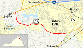
State Route 215 (SR 215) is a primary state highway in the U.S. state of Virginia. Known as Vint Hill Road, the state highway runs 9.26 miles (14.90 km) from U.S. Route 15 and US 29 at Buckland east to SR 28 near Bristow. SR 215 forms part of a connection between Warrenton and Manassas.
Route description
SR 215 begins at an intersection with US 15 and US 29 (Lee Highway) at Buckland just west of the Fauquier – Prince William county line. The state highway heads southeast parallel to the county line, then passes to the north of the Vint Hill Village community as it curves east and enters Prince William County. SR 215 passes through the hamlet of Greenwich and passes to the south of the suburban community of Linton Hall. The state highway reaches its eastern terminus at SR 28 (Nokesville Road) near Bristow.[1][2]
Major intersections
| County | Location | mi[1] | km | Destinations | Notes |
|---|---|---|---|---|---|
| Fauquier | Buckland | 0.00 | 0.00 | ||
| Prince William | Bristow | 9.26 | 14.90 | ||
| 1.000 mi = 1.609 km; 1.000 km = 0.621 mi | |||||
References
- 1 2 3 "2010 Traffic Data". Virginia Department of Transportation. 2010. Retrieved 2011-12-07.
- ↑ Google (2011-12-07). "Virginia State Route 215" (Map). Google Maps. Google. Retrieved 2011-12-07.