Vers, Lot
| Vers | |
|---|---|
|
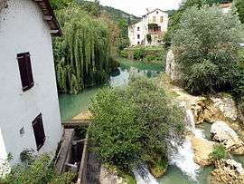
The watermill and waterfall on the Vers river | |
 Vers | |
|
Location within Occitanie region  Vers | |
| Coordinates: 44°29′12″N 1°33′15″E / 44.4867°N 1.5542°ECoordinates: 44°29′12″N 1°33′15″E / 44.4867°N 1.5542°E | |
| Country | France |
| Region | Occitanie |
| Department | Lot |
| Arrondissement | Arrondissement of Cahors |
| Canton | Canton of Saint-Géry |
| Intercommunality | Communauté de communes Lot-Célé |
| Government | |
| • Mayor (2001–2008) | Michel Marsanne |
| Area1 | 17.94 km2 (6.93 sq mi) |
| Population (1999)2 | 398 |
| • Density | 22/km2 (57/sq mi) |
| Time zone | CET (UTC+1) |
| • Summer (DST) | CEST (UTC+2) |
| INSEE/Postal code | 46331 / 46090 |
| Elevation |
110–351 m (361–1,152 ft) (avg. 129 m or 423 ft) |
|
1 French Land Register data, which excludes lakes, ponds, glaciers > 1 km² (0.386 sq mi or 247 acres) and river estuaries. 2 Population without double counting: residents of multiple communes (e.g., students and military personnel) only counted once. | |
Vers is a commune in the Lot department in south-western France.
See also
Gallery
 The village of Vers, Lot
 Watermill on the river Vers in Vers
 Church Notre-Dame-de-Vêles
| Wikimedia Commons has media related to Vers (Lot). |
This article is issued from Wikipedia - version of the 11/13/2016. The text is available under the Creative Commons Attribution/Share Alike but additional terms may apply for the media files.