Montfaucon, Lot
| Montfaucon | ||
|---|---|---|
|
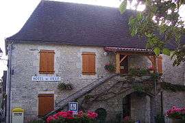
The town hall in Montfaucon | ||
| ||
 Montfaucon | ||
|
Location within Occitanie region  Montfaucon | ||
| Coordinates: 44°41′20″N 1°33′44″E / 44.6889°N 1.5622°ECoordinates: 44°41′20″N 1°33′44″E / 44.6889°N 1.5622°E | ||
| Country | France | |
| Region | Occitanie | |
| Department | Lot | |
| Arrondissement | Gourdon | |
| Canton | Labastide-Murat | |
| Intercommunality | Communauté de communes du Causse de Labastide-Murat | |
| Government | ||
| • Mayor (2008–2014) | Christian Poujade | |
| Area1 | 26.18 km2 (10.11 sq mi) | |
| Population (2004)2 | 568 | |
| • Density | 22/km2 (56/sq mi) | |
| Time zone | CET (UTC+1) | |
| • Summer (DST) | CEST (UTC+2) | |
| INSEE/Postal code | 46204 / 46240 | |
| Elevation |
260–423 m (853–1,388 ft) (avg. 303 m or 994 ft) | |
|
1 French Land Register data, which excludes lakes, ponds, glaciers > 1 km² (0.386 sq mi or 247 acres) and river estuaries. 2 Population without double counting: residents of multiple communes (e.g., students and military personnel) only counted once. | ||
.svg.png)
Montfaucon is a commune in the Lot department in south-western France.
Geography
The river Céou forms part of the commune's northern border.
See also
| Wikimedia Commons has media related to Montfaucon (Lot). |
This article is issued from Wikipedia - version of the 3/28/2015. The text is available under the Creative Commons Attribution/Share Alike but additional terms may apply for the media files.