Vale, South Dakota
| Vale, South Dakota | |
|---|---|
| census-designated place | |
| Coordinates: 44°37′15″N 103°24′12″W / 44.62083°N 103.40333°WCoordinates: 44°37′15″N 103°24′12″W / 44.62083°N 103.40333°W | |
| Country | United States |
| State | South Dakota |
| County | Butte |
| Area | |
| • Total | 0.4 sq mi (1.0 km2) |
| • Land | 0.4 sq mi (1.0 km2) |
| • Water | 0.0 sq mi (0.0 km2) |
| Elevation | 2,700 ft (823 m) |
| Population (2010) | |
| • Total | 136 |
| • Density | 340/sq mi (136/km2) |
| Time zone | Mountain (MST) (UTC-7) |
| • Summer (DST) | MDT (UTC-6) |
| ZIP code | 57788 |
| Area code(s) | 605 |
| FIPS code | 46-65940[1] |
| GNIS feature ID | 1269098[2] |
Vale is an unincorporated community and census-designated place in Butte County, South Dakota, United States. According to the 2010 Census, the population was 136. Vale has been assigned the ZIP code of 57788.
Vale was so-named because the town site is located in a valley.[3]
References
- ↑ "American FactFinder". United States Census Bureau. Retrieved 2008-01-31.
- ↑ "US Board on Geographic Names". United States Geological Survey. 2007-10-25. Retrieved 2008-01-31.
- ↑ Federal Writers' Project (1940). South Dakota place-names, v.1-3. University of South Dakota. p. 65.
Municipalities and communities of Butte County, South Dakota, United States | ||
|---|---|---|
| Cities | 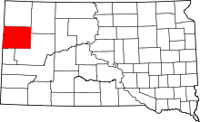 | |
| Towns | ||
| Townships | ||
| Unorganized territories |
| |
| CDP | ||
| Other unincorporated communities | ||
| Ghost town | ||
This article is issued from Wikipedia - version of the 3/16/2016. The text is available under the Creative Commons Attribution/Share Alike but additional terms may apply for the media files.