University Endowment Lands
| University Endowment Lands | |
|---|---|
| Unincorporated area | |
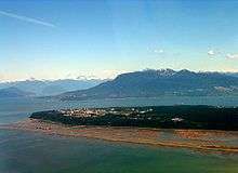
 Location of University Endowment Lands within the Greater Vancouver Regional District in British Columbia, Canada | |
| Country | Canada |
| Province | British Columbia |
| Regional District | Greater Vancouver |
| Government | |
| • MP | Joyce Murray |
| • MLA | David Eby |
| Area | |
| • Total | 14.13 km2 (5.46 sq mi) |
| Elevation | 80 m (260 ft) |
| Population (2001) | |
| • Daytime population | Approx. 40,000 |
| • Permanent population | 7,816 |
| • Permanent population density | 553.15/km2 (1,432.7/sq mi) |
| Time zone | PST (UTC-8) |
| Postal code span | V6S, V6T |
| Area code(s) | 604, 778 |
| Website | University Endowment Lands |
|
(1) Includes daytime UBC population. | |
The University Endowment Lands (UEL) is an unincorporated area that lies to the west of the city of Vancouver, British Columbia, Canada, surrounding the University of British Columbia. Pacific Spirit Regional Park lies within the UEL, and although geographically located within the UEL, the University of British Columbia and private housing on university land are not under the administration of the UEL. This housing, comprising 6000 residents in 2009, is administered by a partnership between the University of British Columbia and the University Neighbourhoods Association (UNA), with the UNA providing most municipal functions. The UEL is part of Metro Vancouver and sometimes considered part of Vancouver (for example, Canada Post uses Vancouver for UEL addresses). The governance arrangements for these three areas are different, however.
The UEL is administered directly by the province and landowners pay their property taxes directly to the provincial government. In a 1995 referendum, UEL residents voted against establishing a municipal governing body.[1]
Geography
The University Endowment Lands are located immediately west of the City of Vancouver. Statistics Canada reports a total land area of 14.13 square kilometres (5.46 sq mi). About half of the UEL is made up of Pacific Spirit Regional Park, a mostly forested land that was originally set aside for development which never materialized. Located on Point Grey, the UEL also boasts tall cliffs near the water, with steep drops of approximately 70 metres (230 ft) down to the beaches below.
Because of its isolated location and the nature of the steep cliffs next to the beaches, Greater Vancouver's only nude beaches are located in the University Endowment Lands, the best known being Wreck Beach, located near the western tip of the peninsula.
Climate
Because the UEL is close to seaside cliffs and the Strait of Georgia, above-average winds are common. Most of the winds come from the Strait itself, Howe Sound and English Bay.
Snowfalls are also more common than many parts of the City of Vancouver because of the area's higher altitude and the lack of an urban heat island due to less terrestrial development.
The UEL has higher humidity compared to other parts of Greater Vancouver because it is surrounded on three sides by water. Fog is common in the winter months, especially in areas near Pacific Spirit Park and the water.

| Climate data for UBC, Vancouver | |||||||||||||
|---|---|---|---|---|---|---|---|---|---|---|---|---|---|
| Month | Jan | Feb | Mar | Apr | May | Jun | Jul | Aug | Sep | Oct | Nov | Dec | Year |
| Record high °C (°F) | 16.4 (61.5) |
17.9 (64.2) |
19.5 (67.1) |
25.0 (77) |
31.0 (87.8) |
30.0 (86) |
31.1 (88) |
32.8 (91) |
30.0 (86) |
25.0 (77) |
17.5 (63.5) |
14.6 (58.3) |
32.8 (91) |
| Average high °C (°F) | 6.0 (42.8) |
7.6 (45.7) |
9.5 (49.1) |
12.3 (54.1) |
15.7 (60.3) |
18.0 (64.4) |
20.4 (68.7) |
20.5 (68.9) |
17.9 (64.2) |
13.1 (55.6) |
8.5 (47.3) |
6.1 (43) |
13.0 (55.4) |
| Daily mean °C (°F) | 3.6 (38.5) |
4.9 (40.8) |
6.6 (43.9) |
9.1 (48.4) |
12.3 (54.1) |
14.7 (58.5) |
16.9 (62.4) |
17.1 (62.8) |
14.5 (58.1) |
10.3 (50.5) |
6.1 (43) |
3.8 (38.8) |
10.0 (50) |
| Average low °C (°F) | 1.2 (34.2) |
2.3 (36.1) |
3.6 (38.5) |
5.7 (42.3) |
8.8 (47.8) |
11.4 (52.5) |
13.2 (55.8) |
13.5 (56.3) |
11.1 (52) |
7.5 (45.5) |
3.7 (38.7) |
1.5 (34.7) |
7.0 (44.6) |
| Record low °C (°F) | −13.9 (7) |
−12.5 (9.5) |
−10.6 (12.9) |
−0.6 (30.9) |
1.7 (35.1) |
2.6 (36.7) |
7.3 (45.1) |
6.1 (43) |
0.6 (33.1) |
−4.1 (24.6) |
−12.5 (9.5) |
−18.3 (−0.9) |
−18.3 (−0.9) |
| Average precipitation mm (inches) | 162.7 (6.406) |
137.5 (5.413) |
121.9 (4.799) |
89.6 (3.528) |
68.3 (2.689) |
55.5 (2.185) |
39.3 (1.547) |
48.1 (1.894) |
58.6 (2.307) |
113.6 (4.472) |
198.9 (7.831) |
183.5 (7.224) |
1,277.4 (50.291) |
| Source: Environment Canada[2] | |||||||||||||
History
The territory was originally held by the Musqueam Indian Band which still lays claim to the area.
The creation of the University Endowment Lands was first proposed after the passing of the University Endowment Act of 1907, in which the British Columbia provincial government agreed to set aside two million acres (8,000 km2) of British Columbia Crown land to be sold or leased to fund the creation of a university. This land was to be in the Cariboo region of the province's Interior, and consisted of mostly agricultural land. This idea was changed in 1911 when the provincial government passed the University Site Act, which set aside 175 acres (71 ha) in Point Grey for the university. This is where the UEL is located today.
By 1920, it was realized that the Cariboo land did not have a high enough market value to generate the income needed for the university, so that idea was abandoned. This led to the British Columbia University Loan Act, which allowed the Lieutenant-Governor to sell 3,000 acres (12 km2) of Crown land on Point Grey for residential development. The money from the auction was put in the University Endowment Account for the university.[3]
However, a lot of the development that was planned was halted due to economic hardships stemming from the Great Depression. The university could not afford to prepare the land for development or to clear the forest land for development. In the 1930s, the university returned control of the land to the government. By the mid-1950s, over half of the undeveloped land in the UEL remained undeveloped due to the Depression and war shortages in the 1940s.
There have been many attempts to develop this land, which was then opposed by environmentally aware residents in the area. In 1988, the creation of Pacific Spirit Park was announced by the provincial Premier Bill Vander Zalm. The park currently makes up of over half of the UEL, acting as a greenbelt between the developed areas and the City of Vancouver. Development, in large part, is very limited; for any proposed developments in the UEL by the Greater Vancouver Regional District or the University of British Columbia, the following groups must be consulted beforehand: university students, university staff, university faculty, environmental groups, businesses, residents and the general public.[4]
Demographics

The University Endowment Lands' residential population is small and the non-university population includes mostly high-income professionals as the land there is very expensive. The other residents are mostly students living in the university's residences. The 2001 census reported an official permanent population of 7,816.[5] The daytime university population is around 40,000 and includes undergraduate students, graduate students, faculty and staff. As with most universities, diverse cultural and ethnic groups make up the daytime university population, making the UEL very multicultural.
Government and politics
An unincorporated entity, the UEL has no mayor or municipal government. Rather, it is mostly ruled by the University of British Columbia, the Greater Vancouver Regional District (GVRD) and the Province of British Columbia, and they control three entities: the University of British Columbia, University Hill and Pacific Spirit Regional Park. It is part of Electoral Area A of the GVRD.
Residential and commercial taxes are paid directly to the provincial government.
UEL residents are eligible to vote only for school board trustees in City of Vancouver municipal elections.
For provincial elections, the UEL falls under the Vancouver-Point Grey electoral riding. The current Member of the Legislative Assembly is David Eby.
For federal elections, the UEL is in the Vancouver Quadra electoral riding. The seat is held by Joyce Murray.
Transportation
Pacific Spirit Regional Park, at the eastern end of the Endowment Lands, creates a physical buffer between the University and the adjacent Vancouver neighbourhoods of West Point Grey and Dunbar. Because of this, there are only five roads leading from Vancouver into the UEL: North West Marine Drive, 4th Avenue/Chancellor Boulevard, 10th Avenue/University Boulevard, 16th Avenue, and South West Marine Drive.
However, the large number of students and staff commuting to UBC on a daily basis means that the area is easily accessible by public transit. UBC Loop is the western terminus of many TransLink bus routes, and the bus system is heavily used due to a discount bus pass system called U-Pass. The following routes service the UEL and UBC:
- #4 - UBC/Downtown/Powell
- #9 - UBC/Alma/Granville/Broadway Station/Boundary (peak hours only, Monday to Friday)
- #14 - UBC/Hastings
- #25 - UBC/Brentwood Station
- #33 - UBC/29th Avenue Station
- #41 - UBC/Joyce Station (limited service evenings and weekends)
- #43 - UBC/Joyce Station (peak hours, Monday to Friday, express)
- #44 - UBC/Downtown (Waterfront Station) (Monday to Friday, express)
- #49 - UBC/Dunbar Loop/Metrotown Station (peak hours only, Monday to Friday)
- #84 - UBC/VCC–Clark Station (express)
- #99 B-Line - UBC/Commercial–Broadway Station (express)
- #258 - UBC/West Vancouver (Monday to Friday, September to April, express)
- #480 - UBC/Richmond Centre (Monday to Friday, express)
- #N17 - UBC/Downtown (night bus)
- #C18 - UBC/West Mall (local UEL route)
- #C19 - UBC/Alma (Monday to Friday)
- #C20 - UBC/Totem Park (local UEL route)
An additional B-Line bus rapid transit route has been proposed from UBC to Joyce Station, replacing the current #43 UBC/Joyce Station. The Vancouver-UBC Area Transit Plan indicates that service would start in late 2009, to coincide with the opening of the Canada Line. There have also been several proposals for creating a rapid transit link to the university. The most likely candidate for such a service would involve extending the Millennium Line SkyTrain to Granville or Arbutus Street in Vancouver, with a B-Line route continuing on to UBC.
Economy
The UEL is largely a residential neighbourhood, and most economic activity is centred at the University of British Columbia and the area around University Village and University Marketplace. UBC's stores are located mostly in the Student Union Building ("the SUB"). The Village and Marketplace, located next to each other near the intersection of University Boulevard and Allison Road, are located off-campus and home to a food court, several restaurants, some shops, some medical clinics and some services.

In addition to the locations above, there are small cafeterias and cafes located in certain buildings on the UBC campus.
Wesbrook Village is a new community in the southwest. It features condos, shops, and a Save-On-Foods supermarket.
There are also several museums and performing arts theatres on campus, including the Morris and Helen Belkin Art Gallery, the Museum of Anthropology at UBC, the Beaty Biodiversity Museum, the Frederic Wood Theatre, and the Chan Centre.
The eastern end of the UEL is home to the University Golf Course, which is one of the original developments in the non-campus portions of the UEL.
Wreck Beach is also a popular area for locals and tourists alike due to its reputation as one of the largest clothing optional beaches in North America. A thriving market in food, drink, clothing, personal services and various recreational substances has prospered on the beach for decades.
Commercial centres
Wesbrook Village
Wesbrook Village is a small community centre in the southern tip of campus. It currently boasts a coffee shop and a Save-On-Foods Grocery Store. Most of the Village is still under construction however the coffee shop and grocery store are operational and open for business
University Village
The University Village is the first commercial structure built on the UEL. Its main level mostly includes a convenience store, a McDonald's restaurant, a photocopying store and a florist.
The second level is home to a Japanese restaurant, a salon, a pizza parlour and a discount textbook store (which is in direct competition with UBC Bookstore, located on campus).

The basement level is entirely dedicated to a multicultural-themed food court, including Chinese, Japanese, Indian, Middle Eastern, etc.
University Marketplace
The University Marketplace[6] is a mixed commercial-residential structure completed around the late 1990s to the early 2000s. The main floor is home to Rogers Wireless, Staples Business Depot, Starbucks, several restaurants, some cafes and others.
The second floor of the Marketplace contains mostly offices and medical clinics. Some professors from UBC (especially those in the medical field) have offices located there, likely due to the proximity of the science buildings and UBC Hospital.
The upper floors of the Marketplace contain mostly residential apartment housing.
Student Union Building (SUB)
The SUB is home to most of the student clubs at UBC, as well as UBC Food Services (which include fast food services such as A&W and Starbucks), a Travel Cuts location, a salon, both a bar and a pub, a movie theatre, and other student services. It is owned and operated by the Alma Mater Society of the University of British Columbia.
Film industry
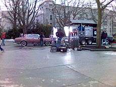

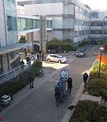
Because many films require university scenes, the UBC/UEL area is a desirable filming location. Combined with the fact that the Vancouver area is the third-largest film production centre in North America, this has made UBC a popular location for many productions. Production companies that wish to shoot on-campus must pay a fee to the university, which goes to the film and theatre departments.
Some notable movies and television shows shot in the UEL include:
- X-Men Origins: Wolverine: Buchanan Tower
- The Exorcism of Emily Rose: UBC's MacMillan Building as the courthouse, Kenny Building as the dorm and Buchanan Building
- 88 Minutes: UBC's Koerner Library area
- Taken: UBC's General Services Administration Building for hostage scenes
- Try Seventeen: UBC's Chan Centre for student orientation scenes
- She's the Man: UBC's Thunderbird Stadium for soccer stadium scenes
- The Butterfly Effect: Koerner Library area, Room 100 of the UBC Geography Building as the lecture hall, and the main mall.
- Wind Chill: UBC's Main Mall
- The 4400: Chan Centre as "The 4400 Center," University Marketplace
- Antitrust: Chan Centre
- Smallville: Koerner and Main Libraries, for exteriors
- Battlestar Galactica: Rose Garden and Chan Centre exterior for "Cloud Nine"
- MacGyver: Various campus exteriors
- Fringe: Flagpole Plaza, Chan Centre exterior and interior, Macleod and Brimacombe Buildings exterior
Education

The UEL is home to the University of British Columbia (hence the name "University Endowment Lands"), the Vancouver School of Theology and Regent College. UBC owns approximately half of the University Endowment Lands; its share forms the university's main campus and research facilities, and those living on UBC property (for example, students) do not pay taxes like non-UBC residents in the UEL.
In addition, the UEL is served by the Vancouver School Board and is zoned to University Hill Secondary School and University Hill Elementary School.
Sports
Most of the UEL's sports activities and facilities are located on the UBC campus. UBC's sports teams are called the UBC Thunderbirds and they play at various locations on campus, including War Memorial Gym, Thunderbird Stadium, UBC Aquatic Centre and Thunderbird Winter Sports Centre. The Student Recreation Centre (REC) is home to intramural sports for students.
2010 Winter Olympics
For the 2010 Winter Olympics and Paralympics, the Thunderbird Winter Sports Centre was replaced by a newer building, named the Doug Mitchell Thunderbird Sports Centre. Demolition of the old arena began in April 2006 and the arena opened on July 7, 2008. The new structure houses three ice rinks, with the main rink accommodating 6,800 spectators.[7]
Emergency services and public safety
- Police
- Unlike neighbouring City of Vancouver, which is under the jurisdiction of Vancouver Police Department, the UEL is under the jurisdiction of the Royal Canadian Mounted Police (RCMP) University detachment because of its Provincial Crown Land status.[8]
- Fire and rescue
- The UEL is served by the Vancouver Fire and Rescue Services under contract.
- Ambulance
- Ambulance service is provided by British Columbia Ambulance Service, as is the entire province.
- Emergency social services
- Organized and provided by the UBC Emergency Planning Office, Department of Health Safety and Environment.
- Health care facilities
- UBC Hospital Urgent Care Centre is the closest hospital. However, for serious symptoms like chest pain, abdominal pain, difficulty breathing or stroke, patients will be transferred to the Vancouver General Hospital.[9]
- If children or women require specialty services, they will be transferred to BC Children's Hospital or BC Women's Hospital & Health Centre.
See also
References
- ↑ "University Endowment Lands". Greater Vancouver Book, 1997. p.109. The Linkman Press, Vancouver BC.
- ↑ "Canadian Climate Normals 1971-2000 - Vancouver Harbour CS". September 2011.
- ↑ http://www.universityendowmentlands.gov.bc.ca/library/Official_Community_Plan.pdf
- ↑ http://www.discovervancouver.com/GVB/ubc-endowment-lands.asp
- ↑ Community Profile: University Endowment Area, British Columbia; Statistics Canada
- ↑ Vancouver's most luxurious rental condominiums. University MarketPlace. Retrieved on 2014-04-12.
- ↑ UBC Thunderbird Arena
- ↑ Archived March 3, 2007, at the Wayback Machine.
- ↑ Archived October 18, 2007, at the Wayback Machine.
External links
| Wikimedia Commons has media related to University Endowment Lands, British Columbia. |
- University Endowment Lands Homepage
- University Endowment Land Act
- Discover Vancouver - University Endowment Lands
- The University of British Columbia
- University Marketplace

Wikivoyage has a travel guide for Vancouver/UBC.
Surrounding municipalities
 |
Bowen Island | West Vancouver | District and City of North Vancouver | |
| |
Vancouver | |||
| ||||
| | ||||
| Strait of Georgia | Richmond |
Municipalities of Metro Vancouver | |
|---|---|
| Population over 500,000 | |
| Population over 100,000 | |
| Population over 50,000 | |
| Population over 10,000 | |
| Population under 10,000 | |
| Unincorporated areas | |
| |
| Downtown neighbourhoods | ||
|---|---|---|
| West Side neighbourhoods | ||
| East Side neighbourhoods | ||
| Other locations | ||
Italics indicate neighbourhoods now defunct. | ||
| Subdivisions |  | |
|---|---|---|
| Communities | ||
| Metro areas and agglomerations | ||
| ||
Coordinates: 49°15′29″N 123°13′41″W / 49.258°N 123.228°W