Uniontown Historic District (Uniontown, Maryland)
|
Uniontown Historic District | |
 | |
  | |
| Location | Uniontown and Trevanion Rds., Uniontown, Maryland |
|---|---|
| Coordinates | 39°35′40″N 77°6′55″W / 39.59444°N 77.11528°WCoordinates: 39°35′40″N 77°6′55″W / 39.59444°N 77.11528°W |
| Area | 122 acres (49 ha) |
| Architectural style | Mixed (more Than 2 Styles From Different Periods) |
| NRHP Reference # | 86000059[1] |
| Added to NRHP | January 3, 1986 |
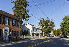
Uniontown Historic District is a national historic district at Uniontown, Carroll County, Maryland, United States. The district comprises nearly the entirety of Uniontown and contains a remarkably cohesive and well-preserved collection of houses, commercial buildings, churches, and schools reflecting the development of this agricultural village from the turn of the 19th century through the 1930s. It is an example of a linear townscape typical of small settlements in rural north-central Maryland during the 19th century.[2]
It was added to the National Register of Historic Places in 1986.[1]
References
- 1 2 National Park Service (2010-07-09). "National Register Information System". National Register of Historic Places. National Park Service.
- ↑ Joe Getty (1985). "National Register of Historic Places Registration: Uniontown Historic District" (PDF). Maryland Historical Trust. Retrieved 2016-01-01.
External links
- Uniontown Historic District, Carroll County, including photo from 1984, at Maryland Historical Trust
- Boundary Map of the Uniontown Historic District, Carroll County, at Maryland Historical Trust
| Topics |  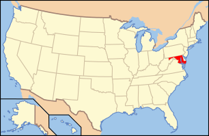 | |
|---|---|---|
| Lists by county | ||
| Lists by city | ||
| Other lists | ||
| ||
This article is issued from Wikipedia - version of the 11/29/2016. The text is available under the Creative Commons Attribution/Share Alike but additional terms may apply for the media files.