Union Township, Doniphan County, Kansas
| Union Township | |
|---|---|
| Township | |
 Location in Doniphan County | |
| Coordinates: 39°41′53″N 095°17′19″W / 39.69806°N 95.28861°WCoordinates: 39°41′53″N 095°17′19″W / 39.69806°N 95.28861°W | |
| Country | United States |
| State | Kansas |
| County | Doniphan |
| Area | |
| • Total | 36.14 sq mi (93.6 km2) |
| • Land | 36.11 sq mi (93.52 km2) |
| • Water | 0.03 sq mi (0.08 km2) 0.09% |
| Elevation | 1,099 ft (335 m) |
| Population (2000) | |
| • Total | 360 |
| • Density | 10/sq mi (3.8/km2) |
| GNIS feature ID | 0473270 |
Union Township is a township in Doniphan County, Kansas, USA. As of the 2000 census, its population was 360.
History
Union Township was created in 1878.[1]
Geography
Union Township covers an area of 36.14 square miles (93.6 km2) and contains one incorporated settlement, Denton. According to the USGS, it contains five cemeteries: Anderson, Denton, Robertson, Saint Marys and Victory.
References
- ↑ Gray, Patrick Leopoldo (1905). Gray's Doniphan County History: A Record of the Happenings of Half a Hundred Years. Roycroft Press. p. 62.
External links
Municipalities and communities of Doniphan County, Kansas, United States | ||
|---|---|---|
| Cities | 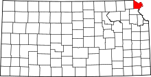 | |
| CDP | ||
| Unincorporated communities | ||
| Ghost town | ||
| Indian reservation | ||
| Townships | ||
| Footnotes | ‡This populated place also has portions in an adjacent county or counties | |
This article is issued from Wikipedia - version of the 10/13/2016. The text is available under the Creative Commons Attribution/Share Alike but additional terms may apply for the media files.